Fine Art Print > North America > United States of America > New York > New York > Maps
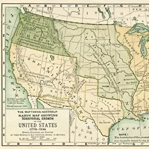
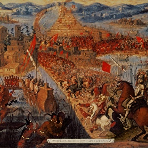
Fine Art Print : Political Map of United States 1895


![]()
Fine Art Prints from Fine Art Storehouse
Political Map of United States 1895
The Rand-McNally Grammar School Geography 1895 - Chicago & New York
Unleash your creativity and transform your space into a visual masterpiece!
THEPALMER
Media ID 14824613
© This content is subject to copyright
Canada Mexico North America United States
A2 (42x59cm) Fine Art Print
Step back in time with our exquisite Political Map of the United States from 1895, part of the Media Storehouse Fine Art Prints collection. This captivating piece, titled "The Palmer Map of the United States," is a historical gem from the Rand-McNally Grammar School Geography published in Chicago and New York. The intricate details of this vintage map offer a unique perspective into the political landscape of the late 19th century. Add an air of sophistication and historical charm to your home or office with this stunning fine art print.
Our Fine Art Prints are printed on 100% acid free, PH neutral paper with archival properties. This printing method is used by museums and art collections to exhibit photographs and art reproductions. Hahnemühle certified studio for digital fine art printing. Printed on 308gsm Photo Rag Paper.
Our fine art prints are high-quality prints made using a paper called Photo Rag. This 100% cotton rag fibre paper is known for its exceptional image sharpness, rich colors, and high level of detail, making it a popular choice for professional photographers and artists. Photo rag paper is our clear recommendation for a fine art paper print. If you can afford to spend more on a higher quality paper, then Photo Rag is our clear recommendation for a fine art paper print.
Estimated Image Size (if not cropped) is 59.4cm x 38.7cm (23.4" x 15.2")
Estimated Product Size is 59.4cm x 42cm (23.4" x 16.5")
These are individually made so all sizes are approximate
Artwork printed orientated as per the preview above, with landscape (horizontal) orientation to match the source image.
FEATURES IN THESE COLLECTIONS
> Arts
> Artists
> M
> Mexican School Mexican School
> Maps and Charts
> Related Images
> North America
> Canada
> Maps
> North America
> Canada
> Related Images
> North America
> Mexico
> Related Images
> North America
> Related Images
> North America
> United States of America
> Maps
> North America
> United States of America
> New Mexico
> Related Images
> North America
> United States of America
> New York
> New York
> Maps
> Fine Art Storehouse
> Map
> Historical Maps
> Fine Art Storehouse
> Map
> USA Maps
EDITORS COMMENTS
In this print titled "Political Map of United States 1895" we are transported back in time to an era when cartography was both a science and an art form. The map, sourced from "The Rand-McNally Grammar School Geography 1895" publication, showcases the intricate details and craftsmanship that went into creating such educational tools. As our eyes wander across the image, we are greeted with a wealth of information about the political landscape of North America during that period. The borders delineating the United States, Canada, and Mexico are clearly defined, reminding us of the historical context in which these nations existed at that time. The meticulousness with which each state is labeled allows us to appreciate the attention given to accuracy and precision. It serves as a reminder of how geography education has evolved over time while highlighting its importance in understanding our world's past. "The Political Map of United States 1895" is not just a visual representation; it carries within it stories of exploration, colonization, and nation-building. This print by THEPALMER invites us to reflect on how far we have come since then while acknowledging the complexities that shaped our continent's history. Whether displayed in classrooms or homes alike, this artwork sparks curiosity and encourages dialogue about our shared heritage. Its timeless appeal lies not only in its aesthetic charm but also in its ability to transport us back to an era long gone yet forever imprinted on this beautifully crafted map.
MADE IN THE UK
Safe Shipping with 30 Day Money Back Guarantee
FREE PERSONALISATION*
We are proud to offer a range of customisation features including Personalised Captions, Color Filters and Picture Zoom Tools
SECURE PAYMENTS
We happily accept a wide range of payment options so you can pay for the things you need in the way that is most convenient for you
* Options may vary by product and licensing agreement. Zoomed Pictures can be adjusted in the Basket.