Fine Art Print > North America > United States of America > New York > New York > Maps
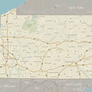
Fine Art Print : Pennsylvania map 1885


![]()
Fine Art Prints from Fine Art Storehouse
Pennsylvania map 1885
Encyclopedia Britannica 9th Edition New York Charles Scribners and Sons 1885 Vol XVIII
Unleash your creativity and transform your space into a visual masterpiece!
THEPALMER
Media ID 14756644
© This content is subject to copyright
A2 (42x59cm) Fine Art Print
Step back in time with our exquisite Pennsylvania Map Fine Art Print from ThePalmer, available at Fine Art Storehouse. This detailed and captivating map, originally published in the Encyclopedia Britannica 9th Edition in 1885, showcases Pennsylvania's historical landscape with meticulous accuracy. The intricate lines and vibrant colors bring the past to life, making this a stunning addition to any home or office. Transport yourself to a bygone era with this beautiful and authentic work of art.
Our Fine Art Prints are printed on 100% acid free, PH neutral paper with archival properties. This printing method is used by museums and art collections to exhibit photographs and art reproductions. Hahnemühle certified studio for digital fine art printing. Printed on 308gsm Photo Rag Paper.
Our fine art prints are high-quality prints made using a paper called Photo Rag. This 100% cotton rag fibre paper is known for its exceptional image sharpness, rich colors, and high level of detail, making it a popular choice for professional photographers and artists. Photo rag paper is our clear recommendation for a fine art paper print. If you can afford to spend more on a higher quality paper, then Photo Rag is our clear recommendation for a fine art paper print.
Estimated Product Size is 59.4cm x 42cm (23.4" x 16.5")
These are individually made so all sizes are approximate
Artwork printed orientated as per the preview above, with landscape (horizontal) orientation to match the source image.
FEATURES IN THESE COLLECTIONS
> Maps and Charts
> Related Images
> North America
> United States of America
> Maps
> North America
> United States of America
> New York
> New York
> Maps
> North America
> United States of America
> New York
> Related Images
> North America
> United States of America
> Pennsylvania
> Related Images
> Fine Art Storehouse
> Map
> Historical Maps
> Fine Art Storehouse
> Map
> USA Maps
EDITORS COMMENTS
This print showcases a historical gem, the Pennsylvania map from 1885. Taken from the renowned Encyclopedia Britannica's 9th Edition, this particular edition was published in New York by Charles Scribners and Sons. The intricate details of this vintage map are truly awe-inspiring, offering a glimpse into the past and allowing us to explore Pennsylvania as it stood over a century ago. The artist behind this remarkable piece is known as THEPALMER, whose expertise in capturing history through photography shines brightly here. The rich colors and fine craftsmanship make for an exquisite visual experience that transports us back to an era when cartography was both artistry and science. Pennsylvania's diverse landscapes come alive on this print - from its bustling cities like Philadelphia and Pittsburgh to its picturesque countryside dotted with charming towns. Each county is meticulously outlined, revealing the state's boundaries with precision. This stunning representation of Pennsylvania serves as a testament to our ever-evolving world while simultaneously reminding us of our roots. Whether you're a history enthusiast or simply appreciate the beauty found in antique maps, this photograph will undoubtedly captivate your imagination. It offers not only aesthetic pleasure but also sparks curiosity about how much has changed since those early days depicted on paper. THEPALMER's skillful lens captures more than just ink on parchment; it encapsulates nostalgia, heritage, and an enduring connection to our past.
MADE IN THE UK
Safe Shipping with 30 Day Money Back Guarantee
FREE PERSONALISATION*
We are proud to offer a range of customisation features including Personalised Captions, Color Filters and Picture Zoom Tools
SECURE PAYMENTS
We happily accept a wide range of payment options so you can pay for the things you need in the way that is most convenient for you
* Options may vary by product and licensing agreement. Zoomed Pictures can be adjusted in the Basket.