Fine Art Print > Africa > Algeria > Maps
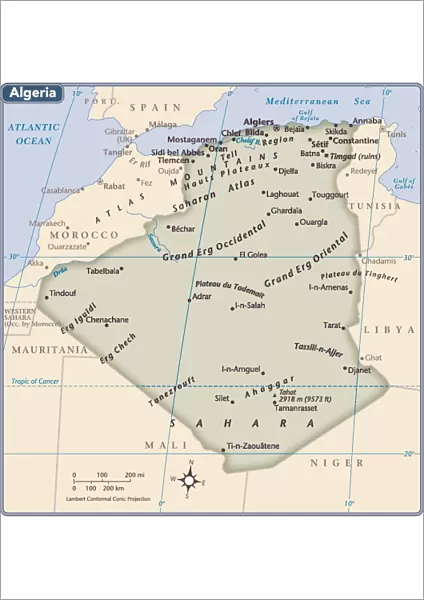
Fine Art Print : Algeria country map


Resolution may be poor at this size (67 DPI)
![]()
Fine Art Prints from Fine Art Storehouse
Algeria country map
2011 edition
Unleash your creativity and transform your space into a visual masterpiece!
Media ID 14432119
A2 (42x59cm) Fine Art Print
Our Fine Art Prints are printed on 100% acid free, PH neutral paper with archival properties. This printing method is used by museums and art collections to exhibit photographs and art reproductions. Hahnemühle certified studio for digital fine art printing. Printed on 308gsm Photo Rag Paper.
Our fine art prints are high-quality prints made using a paper called Photo Rag. This 100% cotton rag fibre paper is known for its exceptional image sharpness, rich colors, and high level of detail, making it a popular choice for professional photographers and artists. Photo rag paper is our clear recommendation for a fine art paper print. If you can afford to spend more on a higher quality paper, then Photo Rag is our clear recommendation for a fine art paper print.
Estimated Image Size (if not cropped) is 42cm x 43cm (16.5" x 16.9")
Estimated Product Size is 42cm x 59.4cm (16.5" x 23.4")
These are individually made so all sizes are approximate
Artwork printed orientated as per the preview above, with portrait (vertical) orientation to match the source image.
FEATURES IN THESE COLLECTIONS
> Africa
> Algeria
> Related Images
> Maps and Charts
> Related Images
> Fine Art Storehouse
> Map
> Reference Maps
EDITORS COMMENTS
This print showcases the intricate details of Algeria's country map, specifically the 2011 edition. With a blend of vibrant colors and precise cartographic lines, this artwork from Fine Art Storehouse is a testament to the beauty and complexity of this North African nation. The map itself serves as more than just a geographical representation; it tells stories of history, culture, and diversity. From the vast Sahara Desert in the south to the stunning Mediterranean coastline in the north, Algeria's diverse landscapes are brought to life through this striking image. Every corner of this expansive country is meticulously depicted on this print. The rugged Atlas Mountains majestically cut across its territory while numerous rivers meander their way through fertile valleys. Cities like Algiers, Oran, and Constantine stand out with their unique urban layouts amidst an array of smaller towns and villages that dot the landscape. Beyond its physical features, Algeria's rich heritage can be explored within these borders. Ancient Roman ruins such as Timgad or Djemila whisper tales from centuries past while traditional Berber villages offer glimpses into indigenous cultures that have thrived for millennia. Whether you're an avid traveler seeking inspiration or simply fascinated by maps' artistic allure, this print captures both aesthetics and information seamlessly. It invites viewers to embark on a visual journey across Algeria's diverse topography while igniting curiosity about its people and history.
MADE IN THE UK
Safe Shipping with 30 Day Money Back Guarantee
FREE PERSONALISATION*
We are proud to offer a range of customisation features including Personalised Captions, Color Filters and Picture Zoom Tools
SECURE PAYMENTS
We happily accept a wide range of payment options so you can pay for the things you need in the way that is most convenient for you
* Options may vary by product and licensing agreement. Zoomed Pictures can be adjusted in the Basket.