Fine Art Print > Maps and Charts > Africa
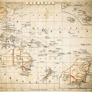
Fine Art Print : Map of North east Africa 1896


![]()
Fine Art Prints from Fine Art Storehouse
Map of North east Africa 1896
Andres Allgemeiner Handatlas - Bielefeld und Leipzig 1896
Unleash your creativity and transform your space into a visual masterpiece!
THEPALMER
Media ID 18356893
A2 (42x59cm) Fine Art Print
Discover the rich history of North East Africa with this stunning fine art print from Media Storehouse. This exquisite Map of North East Africa, published in Andres Allgemeiner Handatlas in 1896, by THEPALMER, showcases intricate detail and historical accuracy. Transport yourself back in time as you explore the borders and territories of the region during this significant era. A perfect addition to any home or office, this fine art print is not only a beautiful decor piece but also a fascinating historical document. Order yours today and bring a piece of the past into your space.
Our Fine Art Prints are printed on 100% acid free, PH neutral paper with archival properties. This printing method is used by museums and art collections to exhibit photographs and art reproductions. Hahnemühle certified studio for digital fine art printing. Printed on 308gsm Photo Rag Paper.
Our fine art prints are high-quality prints made using a paper called Photo Rag. This 100% cotton rag fibre paper is known for its exceptional image sharpness, rich colors, and high level of detail, making it a popular choice for professional photographers and artists. Photo rag paper is our clear recommendation for a fine art paper print. If you can afford to spend more on a higher quality paper, then Photo Rag is our clear recommendation for a fine art paper print.
Estimated Image Size (if not cropped) is 42cm x 51.8cm (16.5" x 20.4")
Estimated Product Size is 42cm x 59.4cm (16.5" x 23.4")
These are individually made so all sizes are approximate
Artwork printed orientated as per the preview above, with portrait (vertical) orientation to match the source image.
FEATURES IN THESE COLLECTIONS
> Africa
> Related Images
> Maps and Charts
> Related Images
> Fine Art Storehouse
> Map
> Historical Maps
EDITORS COMMENTS
This print showcases a historical gem, the "Map of North east Africa 1896" sourced from Andres Allgemeiner Handatlas - Bielefeld und Leipzig 1896. With its intricate details and vintage charm, this piece takes us back to a time when cartography was an art form in itself. The map offers a fascinating glimpse into the past, revealing the political boundaries and geographical features of Northeast Africa as they stood over a century ago. Delicately drawn lines trace the borders of countries that have since undergone significant changes, evoking curiosity about how history has shaped this region. The craftsmanship exhibited in this print is truly remarkable. Every contour and landmark is meticulously depicted, showcasing the dedication and precision required to create such an accurate representation of the land. The faded hues lend an air of nostalgia to the artwork, transporting viewers to a bygone era where exploration and discovery were at their peak. "The Map of North east Africa 1896" serves as both an educational tool for geography enthusiasts and a testament to human ingenuity in capturing our world on paper. It reminds us that maps are not just functional tools but also works of art that can inspire wonderment and spark imagination. Whether displayed in classrooms or homes, this print by THEPALMER from Fine Art Storehouse adds character and depth to any space while offering glimpses into our rich global heritage.
MADE IN THE UK
Safe Shipping with 30 Day Money Back Guarantee
FREE PERSONALISATION*
We are proud to offer a range of customisation features including Personalised Captions, Color Filters and Picture Zoom Tools
SECURE PAYMENTS
We happily accept a wide range of payment options so you can pay for the things you need in the way that is most convenient for you
* Options may vary by product and licensing agreement. Zoomed Pictures can be adjusted in the Basket.