Fine Art Print > North America > Canada > Maps
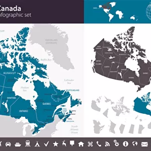
Fine Art Print : Cartoon map of Canada


![]()
Fine Art Prints from Fine Art Storehouse
Cartoon map of Canada
Unleash your creativity and transform your space into a visual masterpiece!
Media ID 14637273
A2 (42x59cm) Fine Art Print
Brighten up your space with the whimsical charm of our Cartoon Map of Canada Fine Art Print from Media Storehouse! This delightful piece of art playfully captures the essence of Canada's unique geography and culture. Each detail, from the iconic maple leaf to the caricatured representations of major cities, is rendered with intricate precision and vibrant colors. Bring a smile to your face and a sense of pride to your home or office with this one-of-a-kind cartoon map. Order now and join the many satisfied customers who have made our Fine Art Prints a cherished addition to their decor.
Our Fine Art Prints are printed on 100% acid free, PH neutral paper with archival properties. This printing method is used by museums and art collections to exhibit photographs and art reproductions. Hahnemühle certified studio for digital fine art printing. Printed on 308gsm Photo Rag Paper.
Our fine art prints are high-quality prints made using a paper called Photo Rag. This 100% cotton rag fibre paper is known for its exceptional image sharpness, rich colors, and high level of detail, making it a popular choice for professional photographers and artists. Photo rag paper is our clear recommendation for a fine art paper print. If you can afford to spend more on a higher quality paper, then Photo Rag is our clear recommendation for a fine art paper print.
Estimated Image Size (if not cropped) is 42cm x 52.7cm (16.5" x 20.7")
Estimated Product Size is 42cm x 59.4cm (16.5" x 23.4")
These are individually made so all sizes are approximate
Artwork printed orientated as per the preview above, with portrait (vertical) orientation to match the source image.
FEATURES IN THESE COLLECTIONS
> Maps and Charts
> Related Images
> North America
> Canada
> Maps
> North America
> Canada
> Related Images
> Fine Art Storehouse
> Map
> Cartoon Maps
EDITORS COMMENTS
This vibrant and whimsical cartoon map of Canada is a delightful piece that captures the essence of this vast and diverse country. Bursting with color, it brings to life the unique characteristics and landmarks that define each province and territory. From coast to coast, this playful illustration showcases iconic symbols such as the majestic Rocky Mountains in Alberta, the stunning Niagara Falls in Ontario, and the picturesque fishing villages of Newfoundland. Each region is depicted with its own distinct charm, highlighting cultural references like hockey players in Quebec or maple syrup production in New Brunswick. The artist's attention to detail is evident throughout this print, as they have carefully crafted every element to create an engaging visual narrative. Whether you're a Canadian proud of your heritage or simply fascinated by our northern neighbor's beauty, this artwork will undoubtedly bring joy and spark conversations. Perfect for any space seeking a touch of lightheartedness or educational flair, this cartoon map invites viewers young and old to explore Canada's rich geography while embracing its playful spirit. Hang it on your wall at home or display it proudly in a classroom setting; either way, it promises endless hours of discovery and appreciation for all things Canadian.
MADE IN THE UK
Safe Shipping with 30 Day Money Back Guarantee
FREE PERSONALISATION*
We are proud to offer a range of customisation features including Personalised Captions, Color Filters and Picture Zoom Tools
SECURE PAYMENTS
We happily accept a wide range of payment options so you can pay for the things you need in the way that is most convenient for you
* Options may vary by product and licensing agreement. Zoomed Pictures can be adjusted in the Basket.