Fine Art Print > Europe > France > Paris > Maps
Fine Art Print : Namur, from Atlas de Louis XIV. Plans des places etrangeres, 1665 (pen


![]()
Fine Art Prints from Fine Art Finder
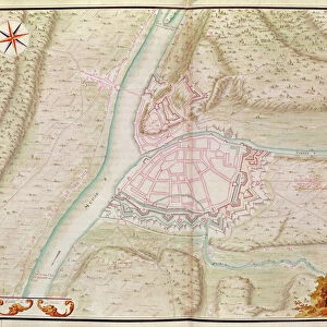
Namur, from Atlas de Louis XIV. Plans des places etrangeres, 1665 (pen
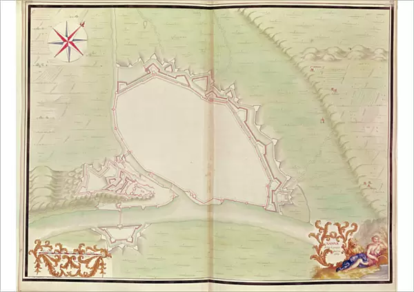
XIR271729 Namur, from Atlas de Louis XIV. Plans des places etrangeres, 1665 (pen, ink & wash) by French School, (17th century); Bibliotheque du Genie, Paris, France; (add.info.: Atlas of foreign places made for the French king, Louis XIV (1638-1715); ); French, out of copyright
Media ID 18254521
© Bibliotheque du Genie, Paris, France / Bridgeman Images
Aerial View City Walls Project Projet Wallonia
A2 (42x59cm) Fine Art Print
Discover the timeless beauty of Namur, as depicted in this exquisite fine art print from the Media Storehouse collection. Originating from the Atlas de Louis XIV, Plans des places etrangeres, 1665, this pen, ink & wash masterpiece by the French School of the 17th century transports you back to an era of grandeur and historical significance. Bring the rich history and culture of Namur into your home or office with this stunning, museum-quality print.
Our Fine Art Prints are printed on 100% acid free, PH neutral paper with archival properties. This printing method is used by museums and art collections to exhibit photographs and art reproductions. Hahnemühle certified studio for digital fine art printing. Printed on 308gsm Photo Rag Paper.
Our fine art prints are high-quality prints made using a paper called Photo Rag. This 100% cotton rag fibre paper is known for its exceptional image sharpness, rich colors, and high level of detail, making it a popular choice for professional photographers and artists. Photo rag paper is our clear recommendation for a fine art paper print. If you can afford to spend more on a higher quality paper, then Photo Rag is our clear recommendation for a fine art paper print.
Estimated Image Size (if not cropped) is 54.8cm x 42cm (21.6" x 16.5")
Estimated Product Size is 59.4cm x 42cm (23.4" x 16.5")
These are individually made so all sizes are approximate
Artwork printed orientated as per the preview above, with landscape (horizontal) orientation to match the source image.
FEATURES IN THESE COLLECTIONS
> Fine Art Finder
> Schools
> French School
> Aerial Photography
> Belgium
> Aerial Photography
> Related Images
> Europe
> Belgium
> Aerial Views
> Europe
> Belgium
> Related Images
> Europe
> France
> Paris
> Maps
EDITORS COMMENTS
This print showcases a remarkable piece of history - Namur, as depicted in the Atlas de Louis XIV. Plans des places etrangeres from 1665. Created by the French School in the 17th century, this pen, ink, and wash artwork offers an aerial view of Namur's city walls. The intricate cartography beautifully captures the essence of this Belgian city located in Wallonia. The project was specifically commissioned for King Louis XIV, known as the Sun King (1638-1715), showcasing his fascination with foreign places. As you delve into this image, you can almost feel yourself transported back to a time when these walls were bustling with life and activity. Namur's rich history is palpable through its well-preserved fortifications depicted on this map. Each stroke of ink brings to life every detail - from the imposing structures that protected its inhabitants to the carefully planned layout of streets and buildings within. As you explore this stunning print further, take note of how it not only serves as a historical document but also as a testament to human ingenuity and architectural prowess during that era. This exceptional piece is housed at Bibliotheque du Genie in Paris, France. Let your imagination soar as you immerse yourself in this extraordinary snapshot from centuries past – an ode to both artistry and exploration.
MADE IN THE UK
Safe Shipping with 30 Day Money Back Guarantee
FREE PERSONALISATION*
We are proud to offer a range of customisation features including Personalised Captions, Color Filters and Picture Zoom Tools
SECURE PAYMENTS
We happily accept a wide range of payment options so you can pay for the things you need in the way that is most convenient for you
* Options may vary by product and licensing agreement. Zoomed Pictures can be adjusted in the Basket.