Fine Art Print > Africa > Algeria > Maps
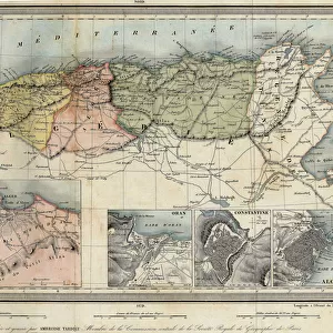
Fine Art Print : Map of North Africa (Mauritania, Morocco, Algeria, Tunisia, Libya) and Europe (Spain
 and Europe (Spain")


![]()
Fine Art Prints from Fine Art Finder
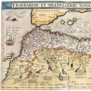
Map of North Africa (Mauritania, Morocco, Algeria, Tunisia, Libya) and Europe (Spain
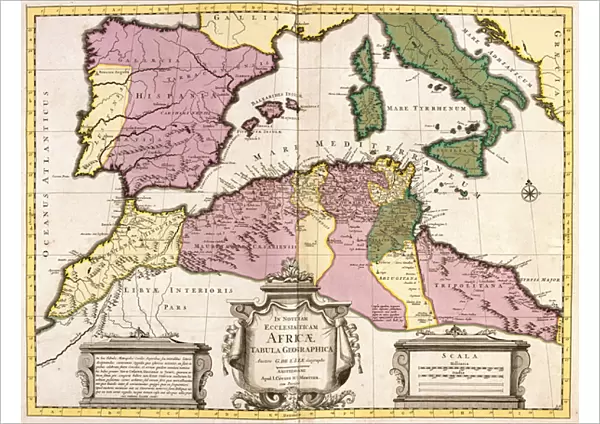
LRI4706827 Map of North Africa (Mauritania, Morocco, Algeria, Tunisia, Libya) and Europe (Spain, Portugal, France, Italy, Greece with Balearic Islands, Sardinia, Corsica and Sicily) (etching, 1730) by Delisle, Guillaume (1675-1726); Private Collection; (add.info.: Map of North Africa (Mauritania, Morocco, Algeria, Tunisia, Libya) and Europe (Spain, Portugal, France, Italy, Greece with Balearic Islands, Sardinia, Corsica and Sicily) - Strong water extracted from the " Atlas Nouveau containing all parts of the world" 1730 by Guillaume de L Isle (1675-1726)); Luisa Ricciarini; French, out of copyright
Media ID 22837162
© Luisa Ricciarini / Bridgeman Images
Algeria Algeria Algerian Algerian Algerians Algerie Atlas Book Corsican Libya Libyan Maghrebin Maghrebine Mauritanian Moroccan Morocco Portugal Portuguese Sardinia Sicilian Sicily Tunisia Tunisian Arab Civilization Geographical Map Maghreb Maghrebi Maghrebian Sudan
A2 (42x59cm) Fine Art Print
Discover the rich cultural connections between North Africa and Europe with this stunning etched map print from the Media Storehouse Fine Art Prints collection. This intricately detailed map, titled "Map of North Africa (Mauritania, Morocco, Algeria, Tunisia, Libya) and Europe (Spain)" by Luisa Ricciarini, showcases the intricate borders and geographical features of the regions, including Spain, Portugal, France, Italy, Greece, the Balearic Islands, Sardinia, Corsica, and Sicily. Bring a touch of history and artistry to your home or office with this beautiful and thought-provoking addition to your decor.
Our Fine Art Prints are printed on 100% acid free, PH neutral paper with archival properties. This printing method is used by museums and art collections to exhibit photographs and art reproductions. Hahnemühle certified studio for digital fine art printing. Printed on 308gsm Photo Rag Paper.
Our fine art prints are high-quality prints made using a paper called Photo Rag. This 100% cotton rag fibre paper is known for its exceptional image sharpness, rich colors, and high level of detail, making it a popular choice for professional photographers and artists. Photo rag paper is our clear recommendation for a fine art paper print. If you can afford to spend more on a higher quality paper, then Photo Rag is our clear recommendation for a fine art paper print.
Estimated Image Size (if not cropped) is 55.3cm x 42cm (21.8" x 16.5")
Estimated Product Size is 59.4cm x 42cm (23.4" x 16.5")
These are individually made so all sizes are approximate
Artwork printed orientated as per the preview above, with landscape (horizontal) orientation to match the source image.
FEATURES IN THESE COLLECTIONS
> Fine Art Finder
> Artists
> Guillaume Delisle
> Africa
> Algeria
> Related Images
> Africa
> Libya
> Related Images
> Africa
> Mauritania
> Maps
> Africa
> Mauritania
> Related Images
> Africa
> Morocco
> Related Images
> Africa
> Related Images
EDITORS COMMENTS
This print showcases a beautifully detailed map of North Africa and Europe, created by the talented Guillaume de L'Isle in 1730. The map encompasses the countries of Mauritania, Morocco, Algeria, Tunisia, Libya in North Africa and Spain, Portugal, France, Italy, Greece with Balearic Islands (such as Sardinia, Corsica), and Sicily in Europe. Etched with precision and skillful artistry on strong water extracted from the "Atlas Nouveau containing all parts of the world" this piece is a true testament to De L'Isle's expertise. The intricate details highlight geographical features such as rivers, mountains ranges and coastlines that define these regions. The fusion of French elegance and Spanish grandeur is evident in this masterpiece. It serves as a historical record capturing the essence of European exploration during the 18th century. This map not only provides valuable information about land boundaries but also offers insights into cultural connections between different civilizations. Luisa Ricciarini has expertly captured this extraordinary artwork through her lens. With her keen eye for detail and composition skills, she brings out every nuance present on this vintage print. This photograph transports us back in time to an era when cartography was at its peak. As we admire this image today, it reminds us of our interconnectedness across continents throughout history. It serves as a visual reminder that borders may divide us geographically but cannot diminish our shared human experiences or cultural heritage.
MADE IN THE UK
Safe Shipping with 30 Day Money Back Guarantee
FREE PERSONALISATION*
We are proud to offer a range of customisation features including Personalised Captions, Color Filters and Picture Zoom Tools
SECURE PAYMENTS
We happily accept a wide range of payment options so you can pay for the things you need in the way that is most convenient for you
* Options may vary by product and licensing agreement. Zoomed Pictures can be adjusted in the Basket.