Home > Europe > United Kingdom > Wales > Gwent > Newport
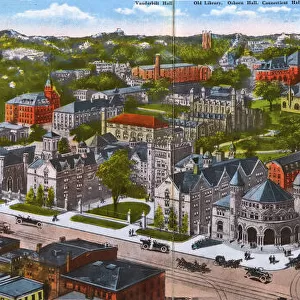
Map of Connecticut and Rhode Island, c.1900 (engraving)
")
![]()
Wall Art and Photo Gifts from Fine Art Finder
Map of Connecticut and Rhode Island, c.1900 (engraving)
533101 Map of Connecticut and Rhode Island, c.1900 (engraving); (add.info.: Map of Connecticut and Rhode Island, United States, with an inset of Newport, circa 1902, from the 10th edition of Encyclopaedia Britannica.); Encyclopaedia Britannica/UIG
Media ID 38309810
© Encyclopaedia Britannica/UIG / Bridgeman Images
1902 19th Century Style Atlantic Ocean Boundary Connecticut Geographical Border Guidance Illustration Technique Navigational Equipment Newport Old Fashioned Physical Geography Rhode Island State The Past Us State Border Western Script
FEATURES IN THESE COLLECTIONS
> Europe
> United Kingdom
> Wales
> Gwent
> Newport
> Europe
> United Kingdom
> Wales
> Pembrokeshire
> Newport
> Fine Art Finder
> Temp Classification
> North America
> United States of America
> Connecticut
> Related Images
> North America
> United States of America
> Maps
> North America
> United States of America
> Rhode Island
> Related Images
EDITORS COMMENTS
This stunning engraving from the 10th edition of Encyclopaedia Britannica showcases a detailed Map of Connecticut and Rhode Island circa 1900. The intricate cartography, done in a 19th-century style, highlights the coastline, boundaries, and geographical features of these two New England states.
The inclusion of an inset featuring Newport adds to the historical charm of this piece, offering a glimpse into the past exploration and navigation of this region. The map captures the essence of old-fashioned navigational equipment and Western script used during that era.
As you study this print, you can almost imagine sailors using it for guidance as they traverse Long Island Sound and the Atlantic Ocean. The absence of people in the image allows you to focus solely on the physical geography and state borders depicted with precision.
This illustration serves as a reminder of how maps were once essential tools for understanding our world before modern technology made them accessible at our fingertips. It is a testament to both artistry and functionality, showcasing the beauty found in even the most practical objects like maps.
MADE IN THE UK
Safe Shipping with 30 Day Money Back Guarantee
FREE PERSONALISATION*
We are proud to offer a range of customisation features including Personalised Captions, Color Filters and Picture Zoom Tools
SECURE PAYMENTS
We happily accept a wide range of payment options so you can pay for the things you need in the way that is most convenient for you
* Options may vary by product and licensing agreement. Zoomed Pictures can be adjusted in the Basket.