Home > Arts > Artists > H > Diego Homem
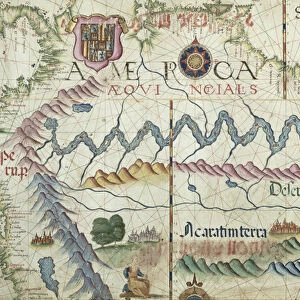
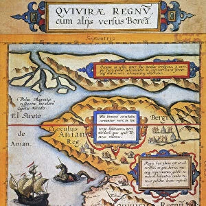
Peru and the Amazon, detail from a world atlas, 1565 (vellum)
")
![]()
Wall Art and Photo Gifts from Fine Art Finder
Peru and the Amazon, detail from a world atlas, 1565 (vellum)
XJL208771 Peru and the Amazon, detail from a world atlas, 1565 (vellum) by Homem, Diego (16th century); The National Library of Russia, St. Petersburg, Russia; Portuguese, out of copyright
Media ID 12705313
© www.bridgemanart.com
Cartography Compass Del Mundo Diego Homm Portugues
FEATURES IN THESE COLLECTIONS
> Arts
> Artists
> H
> Diego Homem
> Arts
> Landscape paintings
> Waterfall and river artworks
> River artworks
> Fine Art Finder
> Artists
> Diego Homem
> Maps and Charts
> World
> South America
> Peru
> Maps
EDITORS COMMENTS
This print showcases a remarkable piece of history - "Peru and the Amazon, detail from a world atlas, 1565" by Diego Homem. Created on vellum, this intricate map is housed in The National Library of Russia in St. Petersburg. The image transports us back to the 16th century when cartography was still an evolving art form. With its rich Portuguese influence evident through the use of language and coat of arms, this map offers a glimpse into the exploration and colonization efforts during that time. The main focus lies on South America's vibrant landscape, specifically Peru and the mighty Amazon River. Every detail has been meticulously crafted; from the winding river channels to lush forests teeming with life. This artwork not only serves as a navigational tool but also as an artistic representation of nature's beauty. A compass rose elegantly adorns one corner of the map, reminding viewers of its practical purpose for sailors embarking on perilous journeys across uncharted waters. As we admire this extraordinary piece, it is important to acknowledge its historical significance rather than solely considering it for commercial purposes. Let us appreciate how maps like these were instrumental in shaping our understanding of geography and fostering cultural exchanges between nations throughout centuries past.
MADE IN THE UK
Safe Shipping with 30 Day Money Back Guarantee
FREE PERSONALISATION*
We are proud to offer a range of customisation features including Personalised Captions, Color Filters and Picture Zoom Tools
SECURE PAYMENTS
We happily accept a wide range of payment options so you can pay for the things you need in the way that is most convenient for you
* Options may vary by product and licensing agreement. Zoomed Pictures can be adjusted in the Basket.