Home > Europe > United Kingdom > England > Cambridge
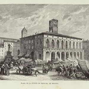
Map of the Counts of Huntingdon and Cambridge (England), circa 1870. 19th century lithography
, circa 1870. 19th century lithography")
![]()
Wall Art and Photo Gifts from Fine Art Finder
Map of the Counts of Huntingdon and Cambridge (England), circa 1870. 19th century lithography
NWI4874992 Map of the Counts of Huntingdon and Cambridge (England), circa 1870. 19th century lithography.; (add.info.: Map of the Counts of Huntingdon and Cambridge (England), circa 1870. 19th century lithography.); Photo © North Wind Pictures
Media ID 38265770
© Photo © North Wind Pictures / Bridgeman Images
FEATURES IN THESE COLLECTIONS
> Europe
> United Kingdom
> England
> Cambridge
> Europe
> United Kingdom
> England
> Maps
> Europe
> United Kingdom
> Maps
> Fine Art Finder
> Artists
> Spanish School (after)
> Maps and Charts
> Early Maps
EDITORS COMMENTS
This stunning lithograph print showcases a Map of the Counts of Huntingdon and Cambridge in England, dating back to circa 1870. The intricate details and vibrant colors bring this 19th-century geographical map to life, offering a glimpse into the historical landscape of Britain during that era.
The fine craftsmanship of the engraving is evident in every line and curve, highlighting the skill and artistry of the unknown creator behind this masterpiece. From the delicate shading to the precise labeling of towns and landmarks, each element on this map tells a story of a bygone time.
As we gaze upon this image, we are transported back to a time when cartography was both science and art, combining accuracy with aesthetic appeal. The Map of the Counts of Huntingdon and Cambridge serves as a window into history, allowing us to explore the geography and boundaries that defined these regions in England over a century ago.
Whether you are an avid collector of antique maps or simply appreciate beautiful artwork from centuries past, this print is sure to captivate your imagination. Let yourself be drawn into the world depicted on this lithograph, where history unfolds before your eyes in vivid color and detail.
MADE IN THE UK
Safe Shipping with 30 Day Money Back Guarantee
FREE PERSONALISATION*
We are proud to offer a range of customisation features including Personalised Captions, Color Filters and Picture Zoom Tools
SECURE PAYMENTS
We happily accept a wide range of payment options so you can pay for the things you need in the way that is most convenient for you
* Options may vary by product and licensing agreement. Zoomed Pictures can be adjusted in the Basket.