Home > Arts > Artists > M > Gerardus Mercator
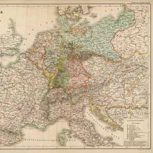
Germany, Czechoslovakia and Poland (engraving, 1596)
")
![]()
Wall Art and Photo Gifts from Fine Art Finder
Germany, Czechoslovakia and Poland (engraving, 1596)
LRI4718057 Germany, Czechoslovakia and Poland (engraving, 1596) by Mercator, Gerardus (1512-94); Private Collection; (add.info.: Saxoniae superioris Lusatiae Misniaeque descriptio, 1610: Germany, Czechoslovakia and Poland - in " Atlas Ssive Corsmographicae Meditationes" by Gerard Mercator (Gerard de Kremer - Gerhard Kremer - Gerardus Mercator) (1512-1594), Duisburg 1596); Luisa Ricciarini; Flemish, out of copyright
Media ID 22464492
© Luisa Ricciarini / Bridgeman Images
Atlas Book Czechoslovakia Geographical Map Poland Polish
FEATURES IN THESE COLLECTIONS
> Arts
> Artists
> M
> Gerardus Mercator
> Fine Art Finder
> Artists
> Gerardus Mercator
> Maps and Charts
> Gerardus Mercator's Cartographic
EDITORS COMMENTS
This print showcases an exquisite engraving from 1596, created by the renowned cartographer Gerardus Mercator. Titled "Germany, Czechoslovakia and Poland" this piece is a part of Mercator's larger work called "Atlas Ssive Corsmographicae Meditationes". The intricate details and precision in this map highlight Mercator's exceptional skill in capturing geographical landscapes. The print depicts Germany, Czechoslovakia, and Poland during the late 16th century. It offers a fascinating glimpse into the political boundaries and topographical features of these regions at that time. With its elaborate engravings, viewers can explore the various cities, rivers, mountains, and forests that define these countries' landscapes. Luisa Ricciarini has masterfully captured this historical artwork through her lens. Her photograph beautifully preserves every minute detail of the original engraving while adding a touch of modernity to it. This print serves as a testament to both Ricciarini's artistic talent and her dedication to preserving cultural heritage. As we admire this remarkable piece of artistry today, we are reminded of how maps have played an essential role throughout history in understanding our world better. They not only provide us with geographical information but also serve as valuable historical artifacts that shed light on past civilizations' knowledge and perceptions. This print is sure to captivate any viewer with its blend of historical significance and artistic brilliance – a true treasure for enthusiasts interested in geography or European history alike.
MADE IN THE UK
Safe Shipping with 30 Day Money Back Guarantee
FREE PERSONALISATION*
We are proud to offer a range of customisation features including Personalised Captions, Color Filters and Picture Zoom Tools
SECURE PAYMENTS
We happily accept a wide range of payment options so you can pay for the things you need in the way that is most convenient for you
* Options may vary by product and licensing agreement. Zoomed Pictures can be adjusted in the Basket.