Home > Europe > Italy > Lazio > Rome
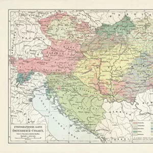
Map of Hungary and Balkans 1683

![]()
Wall Art and Photo Gifts from Fine Art Finder
Map of Hungary and Balkans 1683
7143242 Map of Hungary and Balkans 1683 by Mallet, Alain Manesson (1630-1706); Private Collection; (add.info.: Geography. Hungary. Pannonia (Hungary) and Illyria (Balkans) in the Ancient Rome. Engraving in: Description de l Univers, by Alain Manesson Mallet, France, 1683.); Photo: eArchives Charmet; French, out of copyright
Media ID 24128094
© Photo: Archives Charmet / Bridgeman Images
Antic Rome Balkans Cartography Geographical Map Hungarian Hungarian Hungarian Hungarian Hungary Hungary Hungarian Macedonia Macedonian Macedonians
FEATURES IN THESE COLLECTIONS
> Arts
> Artists
> R
> Roman Roman
> Europe
> Hungary
> Related Images
> Europe
> Italy
> Lazio
> Rome
> Europe
> Macedonia
> Posters
> Europe
> Macedonia
> Related Images
> Fine Art Finder
> Artists
> Alain Manesson Mallet
> Fine Art Finder
> Artists
> French School
> Historic
> Ancient civilizations
> Roman Empire
> Ancient Rome
EDITORS COMMENTS
This print showcases a remarkable piece of history - the "Map of Hungary and Balkans 1683" by Alain Manesson Mallet. Dating back to the 17th century, this antique engraving provides a glimpse into the geographical landscape of Pannonia (Hungary) and Illyria (Balkans) during Ancient Rome. The intricate details on this map offer an insight into the vast territories that were once part of the Roman Empire. From Macedonia to Hungary, every region is meticulously depicted, allowing us to visualize how these lands were connected in ancient times. As we explore this map, we are transported back in time, imagining the bustling cities and vibrant cultures that thrived within these borders. The craftsmanship of Mallet's engraving brings life to each line and contour, showcasing his skill as a cartographer. This print not only serves as a visual delight but also acts as a valuable historical artifact. It reminds us of Europe's rich past and its complex tapestry of nations and empires. Moreover, it highlights Hungary's significance within European history while shedding light on lesser-known regions like Illyria. Whether you are an enthusiast for antiquity or simply appreciate fine art prints with historical value, this "Map of Hungary and Balkans 1683" is sure to captivate your imagination. Let it transport you through time as you delve into the intricacies of ancient geography and discover new perspectives on our shared heritage.
MADE IN THE UK
Safe Shipping with 30 Day Money Back Guarantee
FREE PERSONALISATION*
We are proud to offer a range of customisation features including Personalised Captions, Color Filters and Picture Zoom Tools
SECURE PAYMENTS
We happily accept a wide range of payment options so you can pay for the things you need in the way that is most convenient for you
* Options may vary by product and licensing agreement. Zoomed Pictures can be adjusted in the Basket.