Home > Arts > Artists > W > Frederick de Wit
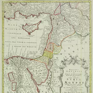
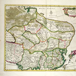
Historical Atlas of Mesopotamia. Babylonia, Syria and Assyria. End of 18th century

![]()
Wall Art and Photo Gifts from Fine Art Finder
Historical Atlas of Mesopotamia. Babylonia, Syria and Assyria. End of 18th century
GIA4709833 Historical Atlas of Mesopotamia. Babylonia, Syria and Assyria. End of 18th century. by Unknown artist, (18th century); Private Collection; (add.info.: Historical Atlas of Mesopotamia. Babylonia, Syria and Assyria. End of 18th century.); eGiancarlo Costa; out of copyright
Media ID 22837368
© Giancarlo Costa / Bridgeman Images
Assyria Babylon Geographical Map Iraq Iraqi Mesopotamia Syria Arab Civilization
FEATURES IN THESE COLLECTIONS
> Arts
> Artists
> W
> Frederick de Wit
> Fine Art Finder
> Artists
> Frederick de Wit
> Fine Art Finder
> Artists
> Unknown Artist
> Maps and Charts
> Early Maps
EDITORS COMMENTS
This print showcases the "Historical Atlas of Mesopotamia. Babylonia, Syria and Assyria" from the end of the 18th century. Created by an unknown artist, this exquisite piece is a treasure trove of historical knowledge. The atlas takes us on a journey through time, offering insights into the ancient civilizations that once thrived in this region. The engraving presents a detailed geographical map, allowing us to explore the lands of Iraq and its surrounding areas. From Babylon to Syria and Assyria, each place comes alive with intricate details and precise markings. This visual representation offers a glimpse into the rich cultural heritage that shaped these lands. As we delve deeper into this mesmerizing artwork, we are transported back to an era when Arab civilization flourished in Mesopotamia. The 18th-century setting adds another layer of intrigue as it reflects upon both past and present. Giancarlo Costa's expertise shines through in his careful preservation of this invaluable piece. With every stroke captured flawlessly, he ensures that future generations can appreciate the beauty and significance of these ancient lands. Whether you are a history enthusiast or simply captivated by Middle Eastern antiquity, this print serves as a window into a forgotten world. It invites us to reflect on our shared human history while marveling at the enduring legacy left behind by those who came before us.
MADE IN THE UK
Safe Shipping with 30 Day Money Back Guarantee
FREE PERSONALISATION*
We are proud to offer a range of customisation features including Personalised Captions, Color Filters and Picture Zoom Tools
SECURE PAYMENTS
We happily accept a wide range of payment options so you can pay for the things you need in the way that is most convenient for you
* Options may vary by product and licensing agreement. Zoomed Pictures can be adjusted in the Basket.