Home > Arts > Artists > Related Images
Pages from The Western Pilot... by Samuel Cummings, published by G

![]()
Wall Art and Photo Gifts from Fine Art Finder
Pages from The Western Pilot... by Samuel Cummings, published by G
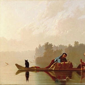
NBY332342 Pages from The Western Pilot... by Samuel Cummings, published by G. Conclin, Cincinnati, 1847 (litho) by American School, (19th century); Newberry Library, Chicago, Illinois, USA; (add.info.:containing charts of the Ohio River, and of the Mississippi, from the mouth of the Missouri to the Gulf of Mexico... ; ); eNewberry Library; American, out of copyright
Media ID 22947064
© Newberry Library / Bridgeman Images
Aerial View Cartography Mapping
FEATURES IN THESE COLLECTIONS
> Arts
> Artists
> Related Images
> Arts
> Landscape paintings
> Waterfall and river artworks
> River artworks
> Fine Art Finder
> America & American Art (+canada)
> Fine Art Finder
> Artists
> American School
> Fine Art Finder
> Artists
> English School
> Maps and Charts
> Early Maps
> North America
> Canada
> Maps
> North America
> Mexico
> Maps
> North America
> United States of America
> Illinois
> Chicago
> North America
> United States of America
> Maps
> North America
> United States of America
> Mississippi
> Related Images
> North America
> United States of America
> Missouri
> Related Images
EDITORS COMMENTS
This print showcases a remarkable piece of American history, featuring pages from "The Western Pilot" by Samuel Cummings. Published in 1847 by G. Conclin in Cincinnati, this lithograph is an exquisite example of 19th-century cartography and travel literature. The pages displayed in the photograph contain detailed charts of the Ohio River and the Mississippi, spanning from the mouth of the Missouri all the way to the Gulf of Mexico. These maps were invaluable resources for travelers and explorers during that era, providing crucial information about navigation routes and geographical features. The aerial view depicted in this print offers a unique perspective on North America's vast landscapes, inviting viewers to imagine themselves embarking on adventurous journeys across these majestic rivers. The meticulous engravings beautifully capture every intricate detail, showcasing both artistic skill and scientific precision. Preserved at Newberry Library in Chicago, Illinois, this historical artifact serves as a testament to America's rich mapping heritage. Its significance lies not only in its practical use but also as a reflection of how early Americans perceived their expanding nation. As we admire this extraordinary lithograph today, we are reminded of our ancestors' thirst for exploration and knowledge. It stands as a tribute to those who paved the way for us to better understand our continent's geography while offering us an opportunity to appreciate their artistry through time-honored engravings like these.
MADE IN THE UK
Safe Shipping with 30 Day Money Back Guarantee
FREE PERSONALISATION*
We are proud to offer a range of customisation features including Personalised Captions, Color Filters and Picture Zoom Tools
SECURE PAYMENTS
We happily accept a wide range of payment options so you can pay for the things you need in the way that is most convenient for you
* Options may vary by product and licensing agreement. Zoomed Pictures can be adjusted in the Basket.