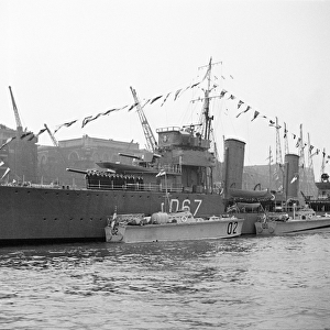
Home > Europe > United Kingdom > England > London > Museums > National Maritime Museum
A chart of Broach Bar and river surveyed by Lieut WIlliam Augustus Skynner 1773, 1775 (print)
")
![]()
Wall Art and Photo Gifts from Fine Art Finder
A chart of Broach Bar and river surveyed by Lieut WIlliam Augustus Skynner 1773, 1775 (print)
7340638 A chart of Broach Bar and river surveyed by Lieut WIlliam Augustus Skynner 1773, 1775 (print) by British School, (18th Century); 18.8x35.6 cm; National Maritime Museum, London, UK; (add.info.: Creator: British Admiralty; Dalrymple; Lieutenant William Augustus Skynner; Mr Smith
Scale: circa 1:200, 000); © National Maritime Museum, Greenwich, London
Media ID 38515564
© © National Maritime Museum, Greenwich, London / Bridgeman Images
FEATURES IN THESE COLLECTIONS
> Animals
> Insects
> Hemiptera
> Black Scale
> Arts
> Artists
> I
> Indian School Indian School
> Arts
> Artists
> W
> William White
> Asia
> India
> Related Images
> Europe
> United Kingdom
> England
> London
> Boroughs
> Greenwich
> Europe
> United Kingdom
> England
> London
> Museums
> British Museum
> Europe
> United Kingdom
> England
> London
> Museums
> Greenwich Heritage Centre
> Europe
> United Kingdom
> England
> London
> Museums
> National Maritime Museum
> Europe
> United Kingdom
> England
> London
> Sights
> British Museum
> Fine Art Finder
> Artists
> British School
EDITORS COMMENTS
This stunning print showcases a chart of Broach Bar and river, meticulously surveyed by Lieutenant William Augustus Skynner in 1773 and 1775. The intricate details captured in this piece offer a glimpse into the expertise and precision of British cartographers during the 18th century.
Measuring at 18.8x35.6 cm, this historical artifact is housed at the National Maritime Museum in London, UK. Created by the British Admiralty under the guidance of Dalrymple, Skynner, and Mr Smith, this map boasts a scale of approximately 1:200,000.
The monochromatic aesthetic adds to the timeless appeal of this piece as it transports viewers back to an era when exploration and discovery were paramount. The map not only serves as a navigational tool but also as a work of art that celebrates the beauty and complexity of India's waterways.
As we admire this print, we are reminded of the dedication and skill required to produce such detailed maps without modern technology. It stands as a testament to human ingenuity and perseverance in unraveling the mysteries of our world.
Through this image, we are invited to appreciate both the artistry and scientific rigor that went into mapping uncharted territories centuries ago. It is truly a treasure trove for history enthusiasts and admirers of fine craftsmanship alike.
MADE IN THE UK
Safe Shipping with 30 Day Money Back Guarantee
FREE PERSONALISATION*
We are proud to offer a range of customisation features including Personalised Captions, Color Filters and Picture Zoom Tools
SECURE PAYMENTS
We happily accept a wide range of payment options so you can pay for the things you need in the way that is most convenient for you
* Options may vary by product and licensing agreement. Zoomed Pictures can be adjusted in the Basket.