Home > Arts > Artists > A > Battista Agnese
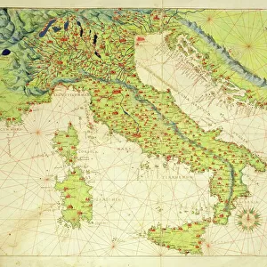
Mount Sinai and the Red Sea, from an Atlas of the World in 33 Maps, Venice, 1st September 1553

![]()
Wall Art and Photo Gifts from Fine Art Finder
Mount Sinai and the Red Sea, from an Atlas of the World in 33 Maps, Venice, 1st September 1553
XOT330964 Mount Sinai and the Red Sea, from an Atlas of the World in 33 Maps, Venice, 1st September 1553 (ink on vellum) (detail from 330963) by Agnese, Battista (1514-64); Museo Correr, Venice, Italy; Italian, out of copyright
Media ID 12852688
© www.bridgemanart.com
FEATURES IN THESE COLLECTIONS
> Arts
> Artists
> A
> Battista Agnese
> Europe
> Italy
> Veneto
> Venice
> Fine Art Finder
> Artists
> Battista Agnese
> Fine Art Finder
> Maps (celestial & Terrestrial)
> Maps and Charts
> Italy
> Maps and Charts
> World
EDITORS COMMENTS
This print showcases a stunning detail from an Atlas of the World in 33 Maps, created by the talented Italian cartographer Battista Agnese in Venice on September 1st, 1553. The image portrays the majestic Mount Sinai and the awe-inspiring Red Sea, offering viewers a glimpse into the ancient landscapes of the Middle East. Rendered with intricate ink on vellum, this masterpiece captures both the geographical accuracy and artistic finesse that Agnese was renowned for. As we gaze upon this historical artifact preserved at Museo Correr in Venice, Italy, we are transported back to a time when maps were not only practical tools but also works of art. The significance of Mount Sinai as a sacred site is deeply rooted in religious history. It was here that Moses received the Ten Commandments from God according to biblical accounts. This depiction invites us to reflect on spirituality and prayer as it symbolizes man's connection with divinity amidst nature's grandeur. With its rich symbolism and attention to detail, this artwork reminds us of our place within a larger universe while evoking feelings of reverence and wonder. Whether one admires it for its cartographic precision or finds solace in contemplating divine presence through prayerful figures depicted alongside these natural wonders – this image offers something profound for every viewer.
MADE IN THE UK
Safe Shipping with 30 Day Money Back Guarantee
FREE PERSONALISATION*
We are proud to offer a range of customisation features including Personalised Captions, Color Filters and Picture Zoom Tools
SECURE PAYMENTS
We happily accept a wide range of payment options so you can pay for the things you need in the way that is most convenient for you
* Options may vary by product and licensing agreement. Zoomed Pictures can be adjusted in the Basket.