Home > Europe > France > Maps
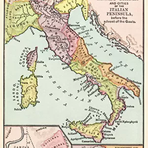
Plate extracted from a historical Atlas by Vidal Lablache, beg of 20th century (print)
")
![]()
Wall Art and Photo Gifts from Fine Art Finder
Plate extracted from a historical Atlas by Vidal Lablache, beg of 20th century (print)
PCT4292088 Plate extracted from a historical Atlas by Vidal Lablache, beg of 20th century (print); (add.info.: Plate extracted from a historical Atlas by Vidal Lablache (Vidal-Lablache: Paul Vidal de la Blache 1845-1918) beginning twenty (20th) century, Bookshop Armand Colin: Maps of the organization of the Roman Empire from Diocletian (284)
Distribution of prefectures according to 4 colors: pink, prefecture of Gauls - yellow, prefecture of Italy - green, prefecture of Illyria - ochre, prefecture of Orient - the boundaries of dioceses are marked in purple -); © Patrice Cartier. All rights reserved 2024
Media ID 38103282
© © Patrice Cartier. All rights reserved 2024 / Bridgeman Images
Africa African African Antic Rome Atlas Book Cartography Celt Population Celtic Celtics Celts Gaul Gauls Geographer Geographical Map Gusman Roman Civilisation
FEATURES IN THESE COLLECTIONS
> Fine Art Finder
> Architecture - Italy - Photograph
> Historic
> Ancient civilizations
> Roman Empire
> Ancient Rome
> Historic
> Ancient civilizations
> Roman Empire
> Roman art
> Maps and Charts
> Early Maps
> Maps and Charts
> Italy
EDITORS COMMENTS
This stunning print showcases a plate extracted from a historical Atlas by Vidal Lablache, dating back to the beginning of the 20th century. The intricate details and vibrant colors bring to life the organization of the Roman Empire from Diocletian's reign in 284 AD.
The map is divided into prefectures, each represented by a different color - pink for Gauls, yellow for Italy, green for Illyria, and ochre for Orient. The boundaries of dioceses are marked in purple, adding another layer of complexity to this fascinating piece of cartography.
As you study this map, you can't help but be transported back in time to ancient Rome and marvel at the sheer size and scope of their empire. The attention to detail and precision in mapping out these regions is a testament to the skill and expertise of Vidal Lablache as a geographer.
Whether you're a history buff or simply appreciate fine art, this print is sure to captivate your imagination and spark your curiosity about the rich history of Europe, Africa, and beyond. It serves as a reminder of our shared past and how geography has played a crucial role in shaping civilizations throughout centuries.
MADE IN THE UK
Safe Shipping with 30 Day Money Back Guarantee
FREE PERSONALISATION*
We are proud to offer a range of customisation features including Personalised Captions, Color Filters and Picture Zoom Tools
SECURE PAYMENTS
We happily accept a wide range of payment options so you can pay for the things you need in the way that is most convenient for you
* Options may vary by product and licensing agreement. Zoomed Pictures can be adjusted in the Basket.