Fraud Blocker Skip to main content

Home > Europe > Ukraine > Maps

Maps Collection

Maps of Ukraine Europe are a great resource for anyone looking to explore the area

Choose a picture from our Maps Collection for your Wall Art and Photo Gifts

198 items

Background imageMaps Collection: Ukraine country map

Ukraine country map
2011 edition

Background imageMaps Collection: Europe Map with France, Portugal, Spain and Netherlands

Europe Map with France, Portugal, Spain and Netherlands
Europe Map. Vector Illustration with France, Portugal, Spain and Netherlands

Background imageMaps Collection: Ukraine / Kiev / Old Map 881

Ukraine / Kiev / Old Map 881
Kiev: the oldest known map

Background imageMaps Collection: Brazil Map with Rivers and National Flag

Brazil Map with Rivers and National Flag
Vintage Map of Brazil. Vector Illustration with Rivers and National Flag

Background imageMaps Collection: Map of Russia

Map of Russia
Reference Map of Russia

Background imageMaps Collection: Map of Ukraine

Map of Ukraine
Reference Maps of Ukraine

Background imageMaps Collection: Ukraine Reference Map

Ukraine Reference Map

Background imageMaps Collection: Historic map of Russia

Historic map of Russia
Illustration of a historic map of Russia

Background imageMaps Collection: UKRAINIAN, 1875 (oil on canvas)

UKRAINIAN, 1875 (oil on canvas)
7215235 UKRAINIAN, 1875 (oil on canvas) by Repin, Ilya Efimovich (1844-1930); Pushkin Museum, Moscow, Russia; (add.info.: 1875//Oil on canvas In Paris)

Background imageMaps Collection: Map of Poland, Belarus and Ukraine, 1899

Map of Poland, Belarus and Ukraine, 1899

Background imageMaps Collection: Antique Ukraine Map

Antique Ukraine Map
Ukraine Map, - Antique style. Includes mountains and water bodies. High detail - vector illustration

Background imageMaps Collection: Map illustrating the Brest-Litovsk Treaties, First World War, c1918, (c1920). Creator: Unknown

Map illustrating the Brest-Litovsk Treaties, First World War, c1918, (c1920). Creator: Unknown
Map illustrating the Brest-Litovsk Treaties, First World War, c1918, (c1920). Pink: Areas taken by Germany ; dark blue: Nationalities of self-determination ; light blue

Background imageMaps Collection: Ukraine Vector Map

Ukraine Vector Map
Highly detailed vector map of Ukraine. File was created on December 16, 2011. The colors in the.eps-file are ready for print (CMYK). Included files: EPS (v8) and Hi-Res JPG

Background imageMaps Collection: Black Sea Sevastopol Harbour from the Russian Survey of 1836, 1853 (print)

Black Sea Sevastopol Harbour from the Russian Survey of 1836, 1853 (print)
7339521 Black Sea Sevastopol Harbour from the Russian Survey of 1836, 1853 (print) by British School, (19th century); 26x52.5 cm; National Maritime Museum, London, UK; (add.info.: British School)

Background imageMaps Collection: Kiev, Smolensk - Voronezh, Russia, 1745

Kiev, Smolensk - Voronezh, Russia, 1745
2902746 Kiev, Smolensk - Voronezh, Russia, 1745; (add.info.: Kiev, Smolensk - Voronezh, Russia, 1745.); Buyenlarge Archive/UIG

Background imageMaps Collection: Sepia map of Kiev downtown (pre-war)

Sepia map of Kiev downtown (pre-war)
Rosana Laiz Blursbyai

Background imageMaps Collection: Sepia map of Kiev (pre-war)

Sepia map of Kiev (pre-war)
Rosana Laiz Blursbyai

Background imageMaps Collection: Ukraine

Ukraine
2901937 Ukraine; (add.info.: The predecessor of Odessa, - small Tatar settlement, was founded by Hac - Giray, the Khan of Crimea, in 1440 and originally named after him as Hac?bey)

Background imageMaps Collection: Russian Tartary, 1745

Russian Tartary, 1745
2902748 Russian Tartary, 1745; (add.info.: Russian Tartary, 1745.); Buyenlarge Archive/UIG

Background imageMaps Collection: Map of the Frontiers of Austria & Russia, 1856. Creator: Unknown

Map of the Frontiers of Austria & Russia, 1856. Creator: Unknown. Map of the Frontiers of Austria & Russia, 1856
Map of the Frontiers of Austria & Russia, 1856. Map showing the area involved in the Crimean War: Black Sea, Transylvania, Hungary, Poland, Turkey, Odessa, Kiev, Bessarabia, Galicia

Background imageMaps Collection: Map of Ukraine, 1650. Creator: Le Vasseur de Beauplan, Guillaume (ca 1600-1673)

Map of Ukraine, 1650. Creator: Le Vasseur de Beauplan, Guillaume (ca 1600-1673)
Map of Ukraine, 1650. Private Collection

Background imageMaps Collection: Map of Ukraine, 1660. Creator: Le Vasseur de Beauplan, Guillaume (ca 1600-1673)

Map of Ukraine, 1660. Creator: Le Vasseur de Beauplan, Guillaume (ca 1600-1673)
Map of Ukraine, 1660. Private Collection

Background imageMaps Collection: Se passant la fantaisie de faire naufrager la flotte Anglo-Française... 19th century

Se passant la fantaisie de faire naufrager la flotte Anglo-Française... 19th century. Creator: Honore Daumier
Se passant la fantaisie de faire naufrager la flotte Anglo-Francaise... 19th century. Indulging in the fantasy of wrecking the Anglo-French fleet

Background imageMaps Collection: Map of Ukraine and surroundings of the Black Sea, um 1700. Creator: Weigel, Christoph

Map of Ukraine and surroundings of the Black Sea, um 1700. Creator: Weigel, Christoph, the Elder (1654-1725)
Map of Ukraine and surroundings of the Black Sea, um 1700. Private Collection

Background imageMaps Collection: Chart showing the relative positions of the batteries and Allied Forces around Sebastopol, 1854

Chart showing the relative positions of the batteries and Allied Forces around Sebastopol, 1854. Creator: Unknown
Chart showing the relative positions of the batteries and Allied Forces around Sebastopol, 1854. From "Cassell's Illustrated Family Paper; London Weekly 31 Dec 1853 to 30 Dec 1854"

Background imageMaps Collection: Sebastopol and Balaclava shewing the position of the Allied Forces, 1854. Creator: John Dower

Sebastopol and Balaclava shewing the position of the Allied Forces, 1854. Creator: John Dower
Sebastopol and Balaclava shewing the position of the Allied Forces, 1854. Crimean War. The severe and costly battles of Balaclava and Inkerman

Background imageMaps Collection: Siege of Sebastopol - map, 1854. Creator: Unknown

Siege of Sebastopol - map, 1854. Creator: Unknown
Siege of Sebastopol - map, 1854. Crimean War. The Black Sea, town and harbour of Sebastopol, Rivers Belbec, Katchka and Alma, Balaklava, roads to Eupatoria and Simferopol, Barren Steppes

Background imageMaps Collection: The Siege of Sebastopol - general view, 1854. Creator: Unknown

The Siege of Sebastopol - general view, 1854. Creator: Unknown
The Siege of Sebastopol - general view, 1854. Crimean War. Map showing the Russian-held ports of Sebastopol and Balaclava, harbours and warships

Background imageMaps Collection: The Coast North of Sebastopol, and New Earth Batteries, 1854. Creator: Unknown

The Coast North of Sebastopol, and New Earth Batteries, 1854. Creator: Unknown
The Coast North of Sebastopol, and New Earth Batteries, 1854. Crimean War. Map of the strategic Black Sea port, ...sketched on board H.M.S

Background imageMaps Collection: New Russian Works, 1854. Creator: Unknown

New Russian Works, 1854. Creator: Unknown
New Russian Works, 1854. Crimean War. Map showing the besieged Black Sea port of Sebastopol. English, French and Turkish ships are ranged across the entrance to the harbour

Background imageMaps Collection: Plan of the Battle of the Alma, 1854. Creator: Unknown

Plan of the Battle of the Alma, 1854. Creator: Unknown
Plan of the Battle of the Alma, 1854. Crimean War. The accompanying plan has been drawn by Major Hopkins, K.H. The different armies are represented by the variety of lines of shade

Background imageMaps Collection: Lieutenant Montagu O'Reilly explaining his Sketch of Sebastopol to the Sultan, 1854

Lieutenant Montagu O'Reilly explaining his Sketch of Sebastopol to the Sultan, 1854. Creator: Unknown
Lieutenant Montagu O'Reilly explaining his Sketch of Sebastopol to the Sultan, 1854. Crimean War: Royal Navy officer with Ottoman sultan Abdulmejid I

Background imageMaps Collection: Map of the Crimea and plan of Sebastopol, 1854. Creator: John Dower

Map of the Crimea and plan of Sebastopol, 1854. Creator: John Dower
Map of the Crimea and plan of Sebastopol, 1854. Crimean War. In the expectation of great sacrifices and severe contests that must attend the attack upon Sebastopol

Background imageMaps Collection: 1 Maps 2 33

1 Maps 2 33
Emiliano Deificus

Background imageMaps Collection: Kharkov Province, 1856. Creator: Unknown

Kharkov Province, 1856. Creator: Unknown
Kharkov Province, 1856. This card is one of a souvenir set of 82 illustrated cards-one for each province of the Russian Empire as it existed in 1856

Background imageMaps Collection: Little Russians. (Ukrainians), 1862. Creator: Karl Fiale

Little Russians. (Ukrainians), 1862. Creator: Karl Fiale
Little Russians. (Ukrainians), 1862. Sheet 5 from the album "Description ethnographique des peuples de la Russie", volume 1

Background imageMaps Collection: Ekaterinoslav Province, 1856. Creator: Unknown

Ekaterinoslav Province, 1856. Creator: Unknown
Ekaterinoslav Province, 1856. This card is one of a souvenir set of 82 illustrated cards-one for each province of the Russian Empire as it existed in 1856

Background imageMaps Collection: Kiev Province, 1856. Creator: Unknown

Kiev Province, 1856. Creator: Unknown
Kiev Province, 1856. This card is one of a souvenir set of 82 illustrated cards-one for each province of the Russian Empire as it existed in 1856

Background imageMaps Collection: Volyn Province, 1856. Creator: Unknown

Volyn Province, 1856. Creator: Unknown
Volyn Province, 1856. This card is one of a souvenir set of 82 illustrated cards-one for each province of the Russian Empire as it existed in 1856

Background imageMaps Collection: Crimean Tatars. Mullah, 1862. Creator: Karlis Huns

Crimean Tatars. Mullah, 1862. Creator: Karlis Huns
Crimean Tatars. Mullah, 1862. Sheet 43 from the album "Description ethnographique des peuples de la Russie", volume 1

Background imageMaps Collection: Cossacks (Uralka, Ural, Donetsk, Chernomoret), 1862. Creator: Karlis Huns

Cossacks (Uralka, Ural, Donetsk, Chernomoret), 1862. Creator: Karlis Huns
Cossacks (Uralka, Ural, Donetsk, Chernomoret), 1862. Sheet 7 from the album "Description ethnographique des peuples de la Russie", volume 1

Background imageMaps Collection: Bukharka. Khivinka. Tatar, 1862. Creator: Karlis Huns

Bukharka. Khivinka. Tatar, 1862. Creator: Karlis Huns
Bukharka. Khivinka. Tatar, 1862. Sheet 46 from the album "Description ethnographique des peuples de la Russie", volume 1

Background imageMaps Collection: Bukharan. Kievan. Tatar, 1862. Creator: Karlis Huns

Bukharan. Kievan. Tatar, 1862. Creator: Karlis Huns
Bukharan. Kievan. Tatar, 1862. Sheet 45 from the album "Description ethnographique des peuples de la Russie", volume 1

Background imageMaps Collection: General Map of Poltava Province: Showing Postal and Major Roads, Stations and... 1821

General Map of Poltava Province: Showing Postal and Major Roads, Stations and... 1821
General Map of Poltava Province: Showing Postal and Major Roads, Stations and the Distance in Versts between Them, 1821. This 1821 map of Poltava Provinceis from a larger work

Background imageMaps Collection: General Map of Ekaterinoslav Province: Showing Postal and Major Roads, Stations and the... 1821

General Map of Ekaterinoslav Province: Showing Postal and Major Roads, Stations and the... 1821
General Map of Ekaterinoslav Province: Showing Postal and Major Roads, Stations and the Distance in Versts between Them, 1821

Background imageMaps Collection: General Map of Chernigov Province: Showing Postal and Major Roads, Stations and... 1821

General Map of Chernigov Province: Showing Postal and Major Roads, Stations and... 1821
General Map of Chernigov Province: Showing Postal and Major Roads, Stations and the Distance in Versts between Them, 1821

Background imageMaps Collection: General Map of Kharkiv Province: Showing Postal and Major Roads, Stations and the... 1821

General Map of Kharkiv Province: Showing Postal and Major Roads, Stations and the... 1821
General Map of Kharkiv Province: Showing Postal and Major Roads, Stations and the Distance in Versts between Them, 1821. This 1821 map of Kharkiv Provinceis from a larger work

Background imageMaps Collection: Kherson Province, 1856. Creator: Unknown

Kherson Province, 1856. Creator: Unknown
Kherson Province, 1856. This card is one of a souvenir set of 82 illustrated cards-one for each province of the Russian Empire as it existed in 1856


All Professionally Made to Order for Quick Shipping


-

Maps Collection

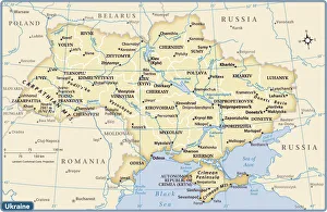
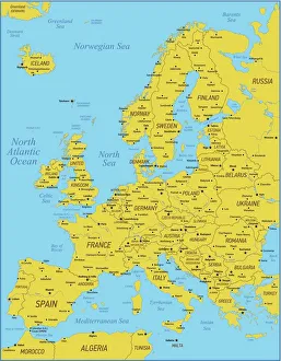
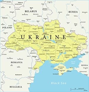
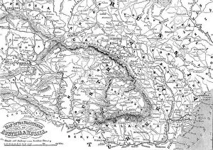
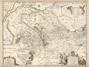
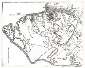
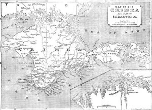
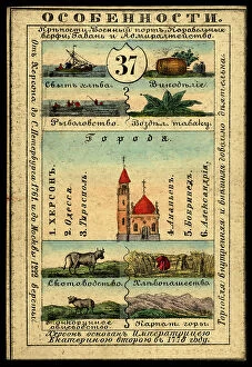
Maps of Ukraine Europe are a great resource for anyone looking to explore the area. They provide detailed information on the country's geography, including its rivers, mountains, cities and towns. These it also highlight major highways and roads that connect Ukraine with other European countries. Additionally, they show the location of airports and train stations in Ukraine as well as important landmarks such as churches and monuments. Maps of Ukraine Europe are available in both digital and print formats, making them easy to access for travelers or those interested in learning more about this fascinating region.
+

Our beautiful pictures are available as Framed Prints, Photos, Wall Art and Photo Gifts

Media Storehouse offers a unique collection of Maps of Ukraine Europe, which includes a range of wall art and framed prints that showcase the beauty and diversity of Ukraine. Our collection features an array of maps that depict different regions, cities, and landmarks in the country. These maps are not only visually stunning but also informative as they provide valuable insights into the geography, history, and culture of Ukraine. Each map is carefully crafted using high-quality materials to ensure longevity and durability. Customers can choose from various sizes and framing options to suit their preferences. Whether you're looking for a statement piece for your living room or office or simply want to add some character to your home decor, our Maps of Ukraine Europe collection has something for everyone. Our collection is an excellent choice for anyone who loves travel or wants to explore new cultures through art. With its beautiful designs and exceptional quality, it's sure to be a conversation starter in any space.
+

What are Maps of Ukraine Europe art prints?

Maps of Ukraine Europe art prints are high-quality reproductions of maps that depict the geography and topography of Ukraine and surrounding European countries. These prints are created using advanced printing techniques to ensure that every detail is captured accurately, making them ideal for both educational and decorative purposes. These maps typically feature a range of information, including borders, cities, rivers, mountains, and other geographical features. They can be used by students studying geography or history as well as by individuals who simply appreciate the beauty of detailed cartography. Maps of Ukraine Europe art prints come in a variety of sizes and styles to suit different tastes and preferences. Some may be more traditional in design while others may have a more modern or artistic flair. Regardless of style, these prints offer an excellent way to explore the world from the comfort of your own home or office.
+

What Maps of Ukraine Europe art prints can I buy from Media Storehouse?

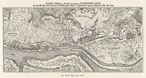
We offer a wide range of Maps of Ukraine Europe art prints that are perfect for anyone who loves geography or history. These maps showcase the intricate details and features of Ukraine, including its cities, rivers, mountains, and borders. You can choose from different styles and sizes to suit your preferences and needs. Some popular options include antique maps that depict the country's past boundaries and territories. There are also modern maps that show the current political divisions and administrative regions. Additionally, you can find relief maps that highlight the topography of Ukraine in three dimensions. Whether you're looking for a decorative piece for your home or office or an educational tool for your classroom or library, we have something to offer. With high-quality printing techniques and materials used in producing these art prints, you can be sure that they will last long while maintaining their vibrant colors and sharp details over time.
+

How do I buy Maps of Ukraine Europe art prints?

To buy Maps of Ukraine Europe art prints from Media Storehouse, you can browse our extensive collection of maps online. Simply search for "Maps of Ukraine" or "Europe Art Prints" on our website and select the ones that you like. Once you have chosen your preferred map, click on it to view more details such as size options and framing choices. You can then add the item to your cart and proceed to checkout where you will be prompted to enter your shipping information and payment details. After completing the purchase process, your order will be processed by our team who will carefully package and ship it out to you. We offer a wide range of high-quality maps printed on premium paper using state-of-the-art printing technology. Their selection includes vintage maps, contemporary designs, and artistic interpretations that are perfect for adding a touch of sophistication to any home or office space.
+

How much do Maps of Ukraine Europe art prints cost?

We offer a wide range of Maps of Ukraine Europe art prints at varying prices. Our collection includes vintage maps, modern maps, and artistic interpretations of the region. The cost depends on factors such as the size of the print and whether it is framed or unframed. We strive to provide high-quality prints that are affordable for our customers. Our Maps of Ukraine Europe art prints are perfect for anyone who loves geography, history, or travel. They make great additions to homes, offices, schools, and other spaces where people gather. Whether you're looking for a unique piece of wall decor or a gift for someone special, we have something that will suit your needs. We take pride in offering excellent customer service and fast shipping times. We want our customers to be completely satisfied with their purchases and enjoy their Maps of Ukraine Europe art prints for years to come.
+

How will my Maps of Ukraine Europe art prints be delivered to me?

We take pride in ensuring that your Maps of Ukraine Europe art prints are delivered to you safely and securely. We use high-quality packaging materials to protect your artwork during transit, so it arrives at your doorstep in pristine condition. Our standard delivery method is via courier service, which allows us to track the progress of your order and provide you with updates on its estimated arrival time. You will receive a notification once your package has been dispatched from our warehouse, along with a tracking number that you can use to monitor its journey. We also offer international shipping for customers outside of the UK. Please note that delivery times may vary depending on your location and local customs regulations. We strive to make sure that receiving your Maps of Ukraine Europe art prints is a hassle-free experience. If you have any questions or concerns about the delivery process, please don't hesitate to contact our customer support team for assistance.