Fraud Blocker Skip to main content

Home > Europe > Malta > Maps

Maps Collection (page 2)

Maps of Malta Europe are a great way to explore the island nation located in the Mediterranean Sea

94 items

Background imageMaps Collection: Map of Tarn-et-Garonne with a view of Montauban and portraits of Ingres

Map of Tarn-et-Garonne with a view of Montauban and portraits of Ingres and Jean Parisot de La Valette (colour litho)
PCT3482842 Map of Tarn-et-Garonne with a view of Montauban and portraits of Ingres and Jean Parisot de La Valette (colour litho) by French School

Background imageMaps Collection: Cartography Hydrographic and Orographic Map of Italy, 1853 (colour litho)

Cartography Hydrographic and Orographic Map of Italy, 1853 (colour litho)
6203313 Cartography Hydrographic and Orographic Map of Italy, 1853 (colour litho) by Italian School, (19th century); (add.info.: CARTOGRAPHY " Hydrographic and orographic map of Italy)

Background imageMaps Collection: St Paul on Malta after his shipwreck (engraving)

St Paul on Malta after his shipwreck (engraving)
7172489 St Paul on Malta after his shipwreck (engraving) by European School, (17th century); Private Collection; (add.info.: St Paul on Malta after his shipwreck (Acts 28)

Background imageMaps Collection: Malta: St Johns Church (b / w photo)

Malta: St Johns Church (b / w photo)
7156409 Malta: St Johns Church (b/w photo) by European Photographer, (19th century); Private Collection; (add.info.: St Johns Church)

Background imageMaps Collection: Plan of Cagliari (Calaris), Sardinia (Italy), Malta (Malta)

Plan of Cagliari (Calaris), Sardinia (Italy), Malta (Malta)
LRI4708517 Plan of Cagliari (Calaris), Sardinia (Italy), Malta (Malta), Rhodes (Rhodus) and Famagusta (Famaugusta), Cyprus (etching, 1572-1617) by Hogenberg

Background imageMaps Collection: Fighting for the Dunghill or Jack Tar settling Buonaparte, pub

Fighting for the Dunghill or Jack Tar settling Buonaparte, pub
2966822 Fighting for the Dunghill or Jack Tar settling Buonaparte, pub. 1798 (hand coloured engraving) by Gillray, James (1757-1815); Private Collection; (add.info)

Background imageMaps Collection: The island of Malta, with Fort St. Elmo (Detail of the Portulan de Castellini

The island of Malta, with Fort St. Elmo (Detail of the Portulan de Castellini
LRI4648312 The island of Malta, with Fort St. Elmo (Detail of the Portulan de Castellini, 17th century) by Unknown Artist, (17th century); Istituto e Museo di Storia della Scienza, Florence

Background imageMaps Collection: Three printed coloured maps: Fairburns New Chart Exhibiting the Route of General

Three printed coloured maps: Fairburns New Chart Exhibiting the Route of General
3062961 Three printed coloured maps: Fairburns New Chart Exhibiting the Route of General Bonaparte in the Mediterranean Sea, 1798 (engraving) by English School, (18th century); National Army Museum

Background imageMaps Collection: View of Malta (engraving, 16th century)

View of Malta (engraving, 16th century)
LRI4647066 View of Malta (engraving, 16th century) by Hogenberg, Franz (1540-c.1590); Private Collection; (add.info.: View of Malta (Malta)

Background imageMaps Collection: Map of the Mediterranean islands of Sicily, Sardinia, Corfu, Malta, Djerba and Elba

Map of the Mediterranean islands of Sicily, Sardinia, Corfu, Malta, Djerba and Elba
LRI4704794 Map of the Mediterranean islands of Sicily, Sardinia, Corfu, Malta, Djerba and Elba, 1570 (engraving) by Ortelius, Abraham (1527-98); Museo Navale di Pegli, Genoa

Background imageMaps Collection: Fighting for the Dunghill, or Jack Tar Settl ing Buonaparte

Fighting for the Dunghill, or Jack Tar Settl ing Buonaparte
NCO190184 Fighting for the Dunghill, or Jack Tar Settl ing Buonaparte, published by Hannah Humphrey in 1798 (etching with aquatint) by Gillray

Background imageMaps Collection: Map of the port of Malta, its fortifications and the castle. 18th century engraving

Map of the port of Malta, its fortifications and the castle. 18th century engraving
LSE4087322 Map of the port of Malta, its fortifications and the castle. 18th century engraving. by Unknown artist, (18th century); Private Collection; (add.info.: Map of the port of Malta)

Background imageMaps Collection: Map of the island of Malta (etching, 1671)

Map of the island of Malta (etching, 1671)
LRI4710727 Map of the island of Malta (etching, 1671) by Wit, Frederick de (1630-1706); Private Collection; (add.info.: Map of the island of Malta - Strong water extracted from " Theatrum)

Background imageMaps Collection: Malta besieged by the Infidel, from Della Architettura Militare

Malta besieged by the Infidel, from Della Architettura Militare
STC214677 Malta besieged by the Infidel, from Della Architettura Militare, published 1551 (engraving) by Marchi, Francesco de (1504-76); Private Collection; (add.info)

Background imageMaps Collection: Map of Calais, Malta, Rhodes, and Famagusta, from Civitates Orbis Terrarum

Map of Calais, Malta, Rhodes, and Famagusta, from Civitates Orbis Terrarum
STC121058 Map of Calais, Malta, Rhodes, and Famagusta, from Civitates Orbis Terrarum by Georg Braun (1541-1622) and Frans Hogenberg (1535-90), c.1572 (coloured engraving) by Hoefnagel

Background imageMaps Collection: Wreck of HMS Sultan, near Malta (engraving)

Wreck of HMS Sultan, near Malta (engraving)
1626346 Wreck of HMS Sultan, near Malta (engraving) by English School, (19th century); Private Collection; (add.info.: Wreck of HMS Sultan, near Malta)

Background imageMaps Collection: Nuneaton may have yielded another important archaeological discovery - the site of a

Nuneaton may have yielded another important archaeological discovery - the site of a Knights Templars house. The Knights Templars were members of a religous order who, during the Crusades

Background imageMaps Collection: The Bone of Contention or the English Bull Dog and the Corsican Monkey, June 14, 1803

The Bone of Contention or the English Bull Dog and the Corsican Monkey, June 14, 1803

Background imageMaps Collection: Hampshire PO2 7 Map

Hampshire PO2 7 Map
Postcode Sector Map of Hampshire PO2 7

Background imageMaps Collection: Thurrock RM18 7 Map

Thurrock RM18 7 Map
Postcode Sector Map of Thurrock RM18 7

Background imageMaps Collection: Oldham OL4 5 Map

Oldham OL4 5 Map
Postcode Sector Map of Oldham OL4 5

Background imageMaps Collection: Medway ME5 0 Map

Medway ME5 0 Map
Postcode Sector Map of Medway ME5 0

Background imageMaps Collection: Rochdale M24 2 Map

Rochdale M24 2 Map
Postcode Sector Map of Rochdale M24 2

Background imageMaps Collection: Manchester M4 7 Map

Manchester M4 7 Map
Postcode Sector Map of Manchester M4 7

Background imageMaps Collection: Knowsley L36 7 Map

Knowsley L36 7 Map
Postcode Sector Map of Knowsley L36 7

Background imageMaps Collection: Liverpool L25 7 Map

Liverpool L25 7 Map
Postcode Sector Map of Liverpool L25 7

Background imageMaps Collection: Edinburgh EH4 1 Map

Edinburgh EH4 1 Map
Postcode Sector Map of Edinburgh EH4 1

Background imageMaps Collection: Hackney E10 7 Map

Hackney E10 7 Map
Postcode Sector Map of Hackney E10 7

Background imageMaps Collection: Islington EC1V 0 Map

Islington EC1V 0 Map
Postcode Sector Map of Islington EC1V 0

Background imageMaps Collection: West Dorset DT1 2 Map

West Dorset DT1 2 Map
Postcode Sector Map of West Dorset DT1 2

Background imageMaps Collection: Cheshire West and Chester CH2 4 Map

Cheshire West and Chester CH2 4 Map
Postcode Sector Map of Cheshire West and Chester CH2 4

Background imageMaps Collection: Chelmsford CM1 2 Map

Chelmsford CM1 2 Map
Postcode Sector Map of Chelmsford CM1 2

Background imageMaps Collection: BA Bath, BA22 8

BA Bath, BA22 8
BA22 8

Background imageMaps Collection: The Port of La Valletta, from a nautical atlas, 1646 (ink on vellum) (detail from 330944)

The Port of La Valletta, from a nautical atlas, 1646 (ink on vellum) (detail from 330944)
XOT330944 The Port of La Valletta, from a nautical atlas, 1646 (ink on vellum) (detail from 330944) by Italian School, (17th century); Museo Correr, Venice, Italy; Italian, out of copyright

Background imageMaps Collection: The enemys hide-out, 1940 (1943)

The enemys hide-out, 1940 (1943)
The enemys hide-out. Taranto, where the Fleet Air Arm sought out the Italian fleet in their own anchorage, 1940 (1943). In November 1940 the British launched an air attack on the Regia Marina naval

Background imageMaps Collection: Labeled European Map

Labeled European Map
Labeled European map concept showing countries with labels. EPS 10 file. Transparency effects used on highlight elements

Background imageMaps Collection: British Empire Exhibition, Wembley

British Empire Exhibition, Wembley
Pictorial folding poster map of the layout of the British Empire Exhibition at Wembley Park, 1924. The exhibition was intended as a celebration of Imperial goods and achievements

Background imageMaps Collection: Turkish Crimean War Medal 1854-1856, Private John Connors VC

Turkish Crimean War Medal 1854-1856, Private John Connors VC, 3rd (The East Kent) Regiment of Foot (The Buffs). (metal)
5925145 Turkish Crimean War Medal 1854-1856, Private John Connors VC, 3rd (The East Kent) Regiment of Foot (The Buffs). (metal) by British School, (19th century); National Army Museum

Background imageMaps Collection: Map Insula Malta Frederick de Wit 1610-1698 Copperplate print

Map Insula Malta Frederick de Wit 1610-1698 Copperplate print
Map, Insula Malta, Frederick de Wit (1610-1698), Copperplate print

Background imageMaps Collection: Map Insularum MelitAŠ vulgo MaltAŠ et GozAŠ novissima delineatio

Map Insularum MelitAŠ vulgo MaltAŠ et GozAŠ novissima delineatio
Map, Insularum Melitae vulgo Maltae et Gozae novissima delineatio, Nicolaes Jansz. Visscher (1618-1679), Copperplate print

Background imageMaps Collection: Map islands Sicily Malta part coast Tunisia New pass

Map islands Sicily Malta part coast Tunisia New pass
Map of the islands of Sicily and Malta and a part of the coast of Tunisia New pass of the sea coasts of the land of Sicily and the coasts of Barbaria between C. Bona and I. Zerby

Background imageMaps Collection: A 19Th Century Map Of Africa Propria And Numidia

A 19Th Century Map Of Africa Propria And Numidia

Background imageMaps Collection: Map of Malta

Map of Malta

Background imageMaps Collection: Map of Malta. Island. Mediterranean Sea. Italian engraving

Map of Malta. Island. Mediterranean Sea. Italian engraving. 16th century

Background imageMaps Collection: Map Insula Malta Frederick de Wit 1610-1698 Copperplate print

Map Insula Malta Frederick de Wit 1610-1698 Copperplate print
Map, Insula Malta, Frederick de Wit (1610-1698), Copperplate print


All Professionally Made to Order for Quick Shipping


-

Maps Collection

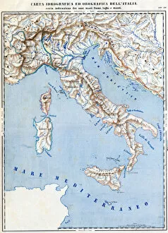
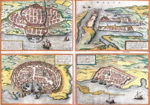
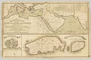
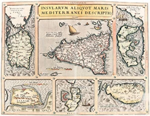
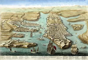
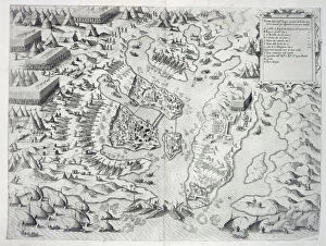
Maps of Malta Europe are a great way to explore the island nation located in the Mediterranean Sea. The maps provide an overview of the country's geography, including its capital city Valletta, its two main islands (Malta and Gozo), and its many smaller islands. They also show major roads and highways, as well as important landmarks such as churches, fortresses, monuments, and other points of interest. Additionally, they provide information on climate zones and natural features like beaches, mountains, rivers and lakes. With these maps one can easily plan a trip to Malta or simply learn more about this fascinating country.
+

Our beautiful Wall Art and Photo Gifts include Framed Prints, Photo Prints, Poster Prints, Canvas Prints, Jigsaw Puzzles, Metal Prints and so much more

The Maps of Malta Europe collection is a stunning array of wall art and framed prints that showcase the beauty and history of Malta. Our collection features a range of maps, including vintage maps from the 16th century to modern-day satellite imagery, all capturing the unique geography and topography of this Mediterranean island nation. Each print in our collection is expertly crafted using high-quality materials to ensure longevity and durability. The prints are available in various sizes, making them perfect for any room or space. Whether you're looking to add some character to your home or office decor or simply want to celebrate your love for Malta, these beautiful prints are sure to impress. From intricate details like street names and landmarks to sweeping views of the coastline, each map offers a glimpse into this fascinating country's rich cultural heritage. If you're looking for an eye-catching piece of wall art that celebrates one of Europe's most captivating destinations, look no further than the Maps of Malta Europe collection from Media Storehouse.
+

What are Maps of Malta Europe art prints?

Maps of Malta Europe art prints are high-quality reproductions of vintage and contemporary maps depicting the Maltese archipelago, located in the Mediterranean Sea. These prints showcase the intricate details and geographical features of Malta, including its cities, towns, villages, coastlines, harbours and landmarks. These art prints are perfect for those who have a passion for geography or history or simply want to add a touch of sophistication to their home decor. They can be framed and hung on walls or displayed on shelves as standalone pieces. Maps of Malta Europe art prints come in various sizes and styles to suit different preferences. Some feature colourful illustrations while others are more minimalist with black-and-white designs. Regardless of style, these prints offer an excellent way to appreciate the beauty and uniqueness of this small but fascinating island nation. Maps of Malta Europe art prints provide a stunning visual representation that captures both the historical significance and natural beauty of this European gem.
+

What Maps of Malta Europe art prints can I buy from Media Storehouse?

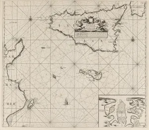
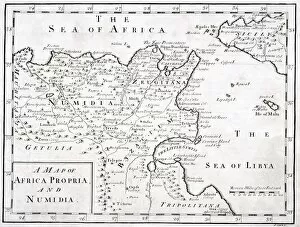
We offer a wide range of Maps of Malta Europe art prints that are perfect for anyone who loves geography or history. These maps showcase the beautiful island nation of Malta, which is located in the Mediterranean Sea and has a rich cultural heritage dating back thousands of years. Some of the most popular Maps of Malta Europe art prints available from Media Storehouse include antique maps that show the island's topography, as well as more modern maps that highlight its cities and landmarks. You can also find detailed nautical charts that depict Malta's coastline and surrounding waters. Whether you're looking to decorate your home or office with a unique piece of artwork, or simply want to add to your collection of historical maps, we have something for everyone. With high-quality printing and materials, these Maps of Malta Europe art prints are sure to impress anyone who sees them.
+

How do I buy Maps of Malta Europe art prints?

To buy Maps of Malta Europe art prints from Media Storehouse, you can browse our extensive collection online. Simply search for "Maps of Malta" in the search bar on our website and select the print that catches your eye. Once you have found a print that you like, click on it to view more details about the product. You will then be able to choose from various sizes and framing options for your chosen print. Add it to your cart and proceed to checkout where you will be prompted to enter your payment information. We offer high-quality art prints that are perfect for adding a touch of elegance and sophistication to any room in your home or office. Our easy-to-use website makes it simple for anyone to find and purchase beautiful artwork without leaving their home. So why wait? Start browsing today.
+

How much do Maps of Malta Europe art prints cost?

We offer a wide range of Maps of Malta Europe art prints that vary in price depending on the size and type of print you choose. Our collection includes high-quality prints featuring detailed maps of Malta and other parts of Europe, which are perfect for adding a touch of sophistication to any room or office space. Our prices are competitive and affordable, making it easy for anyone to purchase one or more Maps of Malta Europe art prints without breaking the bank. We take pride in providing our customers with top-notch products that are not only beautiful but also durable and long-lasting. Whether you're looking for something small to fit into a cozy corner or a large statement piece to hang above your sofa, we have just what you need. So why wait? Browse through our collection today and find the perfect Map of Malta Europe art print that suits your style and budget.
+

How will my Maps of Malta Europe art prints be delivered to me?

We take great care in ensuring that your Maps of Malta Europe art prints are delivered to you safely and securely. We use high-quality packaging materials to protect your artwork during transit, so it arrives at your doorstep in pristine condition. Your Maps of Malta Europe art prints will be shipped directly from our production facility using a reliable courier service. Once dispatched, you will receive an email notification with tracking information so that you can keep track of the delivery status. We offer worldwide shipping options for our customers, and all orders are processed promptly upon receipt. Our team is committed to providing excellent customer service and ensuring that your experience with us is as smooth and hassle-free as possible. Whether you're purchasing art prints for personal or commercial use, we guarantee that they will arrive at their destination on time and in perfect condition.