Cushion > Europe > United Kingdom > England > Yorkshire > Sheffield
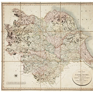
Cushion : A new map of Yorkshire, divided into its ridings and wapentakes, exhibiting its roads, rivers, parks, etc. John Cary, 1810


![]()
Home Decor from Sheffield City Archives
A new map of Yorkshire, divided into its ridings and wapentakes, exhibiting its roads, rivers, parks, etc. John Cary, 1810
Scale 5 1/2 inches : 1 mile.Original at Sheffield Archives (NC/4/1)
Sheffield City Archives and Local Studies Library has an unrivalled collection of images of Sheffield, England
Media ID 14045462
© Sheffield City Council
Medium 18" Cushion (46x46cm)
18"x18" (46x46cm) Fibre filled cushion with a plush soft feel. Your choice of image fills the front, with a stone coloured faux suede back. Flat sewn concealed white zip.
Accessorise your space with decorative, soft cushions
Estimated Product Size is 45.7cm x 45.7cm (18" x 18")
These are individually made so all sizes are approximate
Artwork printed orientated as per the preview above, with landscape (horizontal) or portrait (vertical) orientation to match the source image.
FEATURES IN THESE COLLECTIONS
> Europe
> United Kingdom
> England
> Yorkshire
> Related Images
> Europe
> United Kingdom
> England
> Yorkshire
> Sheffield
> Maps and Charts
> Related Images
> Sheffield City Archives
> Maps and Plans
EDITORS COMMENTS
This print showcases an invaluable piece of history, a meticulously crafted map titled "A new map of Yorkshire, divided into its ridings and wapentakes, exhibiting its roads, rivers, parks, etc". Created by the renowned cartographer John Cary in 1810, this masterpiece offers a fascinating glimpse into the past. The level of detail is truly remarkable as it intricately depicts the intricate network of roads, rivers, and parks that crisscross the vast expanse of Yorkshire. The map's significance lies not only in its accuracy but also in its ability to transport us back to a time when exploration and discovery were at their peak. It serves as a testament to Cary's skillful craftsmanship and his dedication to capturing every minute aspect of this historic county. With a scale ratio of 5 1/2 inches to 1 mile, one can imagine how much effort went into creating such an elaborate representation. Preserved within Sheffield City Archives (NC/4/1), this treasured artifact allows us to connect with our ancestors' journeys through Yorkshire. Whether used for research purposes or simply admired for its aesthetic appeal, this print provides an opportunity for individuals to delve into the rich heritage embedded within these ancient landscapes. It is important to note that while this image may evoke commercial interest due to its historical value and visual allurement; however; we must respect Sheffield City Archives' guidelines regarding non-commercial use. Let us cherish this photograph as a window into our past and appreciate the
MADE IN THE UK
Safe Shipping with 30 Day Money Back Guarantee
FREE PERSONALISATION*
We are proud to offer a range of customisation features including Personalised Captions, Color Filters and Picture Zoom Tools
SECURE PAYMENTS
We happily accept a wide range of payment options so you can pay for the things you need in the way that is most convenient for you
* Options may vary by product and licensing agreement. Zoomed Pictures can be adjusted in the Basket.