Cushion > Arts > Landscape paintings > Waterfall and river artworks > Landscape paintings
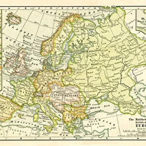
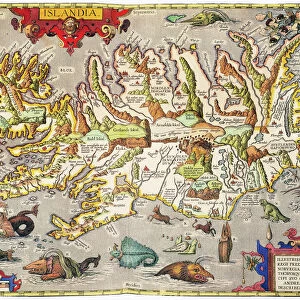
Cushion : Topographic map of Europe, lithograph, published in 1897


![]()
Home Decor from Fine Art Storehouse
Topographic map of Europe, lithograph, published in 1897
Topographic map of Europe. Lithograph, published in 1897
Unleash your creativity and transform your space into a visual masterpiece!
Media ID 15133668
© This content is subject to copyright
Atlantic Ocean Black Sea Caspian Sea European Culture Holidays Iberian Peninsula Iceland Mediterranean Sea Scandinavia Topographic Map Topography Arctic Sea Multi Colored
Medium 18" Cushion (46x46cm)
18"x18" (46x46cm) Fibre filled cushion with a plush soft feel. Your choice of image fills the front, with a stone coloured faux suede back. Flat sewn concealed white zip.
Accessorise your space with decorative, soft cushions
Estimated Product Size is 45.7cm x 45.7cm (18" x 18")
These are individually made so all sizes are approximate
Artwork printed orientated as per the preview above, with landscape (horizontal) or portrait (vertical) orientation to match the source image.
FEATURES IN THESE COLLECTIONS
> Arts
> Artists
> O
> Oceanic Oceanic
> Arts
> Contemporary art
> Landscapes
> Mountain landscapes
> Arts
> Landscape paintings
> Landscape art
> Landscape paintings
> Arts
> Landscape paintings
> Landscape art
> Mountain landscapes
> Arts
> Landscape paintings
> Waterfall and river artworks
> Landscape paintings
> Arts
> Landscape paintings
> Waterfall and river artworks
> River artworks
> Europe
> Iceland
> Related Images
> Fine Art Storehouse
> Map
> Historical Maps
EDITORS COMMENTS
This lithograph, published in 1897, showcases a topographic map of Europe in all its intricate detail. A testament to the rich European culture and history, this print takes us on a journey through time and geography. The map spans from the Atlantic Ocean to the Arctic Sea, encompassing the Mediterranean Sea, Black Sea, and Caspian Sea along its way. The Iberian Peninsula juts out proudly into the vast expanse of water while Scandinavia stands tall with its majestic mountain ranges. The British Islands and Iceland are also prominently featured. Every contour line meticulously engraved on this multi-colored landscape reveals Europe's diverse topography. Rivers meander gracefully across the land, connecting various regions that have witnessed countless historical events throughout centuries past. As we gaze upon this piece of artistry, we cannot help but be transported back to an era when travel was more arduous yet filled with wonder. It evokes a sense of nostalgia for those who yearn for simpler times or dream of exploring these enchanting destinations themselves. The horizontal composition allows us to take in every minute detail at our leisure. This lithograph is not just a mere representation; it is an invitation to delve into Europe's past and immerse ourselves in its beauty. Whether displayed as part of a collection or adorning your study wall, this print serves as both an educational tool and a source of inspiration for wanderlust-filled dreams.
MADE IN THE UK
Safe Shipping with 30 Day Money Back Guarantee
FREE PERSONALISATION*
We are proud to offer a range of customisation features including Personalised Captions, Color Filters and Picture Zoom Tools
SECURE PAYMENTS
We happily accept a wide range of payment options so you can pay for the things you need in the way that is most convenient for you
* Options may vary by product and licensing agreement. Zoomed Pictures can be adjusted in the Basket.