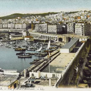
Cushion > Africa > Algeria > Algiers
Cushion : Map drawn up for the Algiers expedition, 1830 (litho) (b / w photo)
 (b / w photo)")
 (b / w photo)")

![]()
Home Decor from Fine Art Finder
Map drawn up for the Algiers expedition, 1830 (litho) (b / w photo)
CHT287706 Map drawn up for the Algiers expedition, 1830 (litho) (b/w photo) by French School, (19th century); Bibliotheque Nationale, Paris, France; (add.info.: carte dressee pour l expedition d Alger; Alger; French conquest; imperialism; colonisation; ); eArchives Charmet; French, out of copyright
Media ID 22358624
© Archives Charmet / Bridgeman Images
Algeria Algeria Algerian Algerian Algerians Balearic Islands Corsica Majorca Mediterranean Minorca Morocco Sardinia Sicily Tunisia Tyrrhenian Sea Algerian Coast Arab Civilization Balearics Ibiza Maghreb Maghrebi Maghrebian South France Sudan
Medium 18" Cushion (46x46cm)
18"x18" (46x46cm) Fibre filled cushion with a plush soft feel. Your choice of image fills the front, with a stone coloured faux suede back. Flat sewn concealed white zip.
Accessorise your space with decorative, soft cushions
Estimated Product Size is 45.7cm x 45.7cm (18" x 18")
These are individually made so all sizes are approximate
Artwork printed orientated as per the preview above, with landscape (horizontal) or portrait (vertical) orientation to match the source image.
FEATURES IN THESE COLLECTIONS
> Africa
> Algeria
> Related Images
> Africa
> Morocco
> Related Images
> Africa
> Related Images
> Africa
> South Africa
> Maps
> Africa
> South Africa
> Related Images
> Africa
> South Sudan
> Maps
> Africa
> South Sudan
> Related Images
> Fine Art Finder
> Artists
> French School
> Fine Art Finder
> Artists
> Gerlier (after)
> Fine Art Finder
> Maps (celestial & Terrestrial)
EDITORS COMMENTS
This print showcases a historic map drawn up for the Algiers expedition in 1830. Created by French School in the 19th century, this lithograph provides a fascinating glimpse into the era of French conquest, imperialism, and colonization. The map encompasses various regions including Algeria, Spain, Sicily, Minorca, South France, Balearics, Tyrrhenian Sea, Majorca, North Africa, Balearic Islands, Italy, Sardinia and more. With intricate details and precise markings on display here at Bibliotheque Nationale in Paris, France; this map was an essential tool during the Algerian expedition. It highlights strategic locations such as the Bay of Algiers and Corsica while also encompassing Morocco's coastline and Tunisia. The significance of this map extends beyond its geographical accuracy. It represents not only European expansion but also Arab civilization's interaction with African territories. The presence of Maghreb countries like Sudan adds to its historical value. As we explore this image from eArchives Charmet courtesy of Bridgeman Images (not affiliated with any company), it is important to appreciate its cultural importance without commercial intentions. This photograph serves as a reminder of our collective history - one that shaped nations through exploration and colonization but also reflects upon the diverse civilizations that have thrived across Africa over centuries.
MADE IN THE UK
Safe Shipping with 30 Day Money Back Guarantee
FREE PERSONALISATION*
We are proud to offer a range of customisation features including Personalised Captions, Color Filters and Picture Zoom Tools
FREE COLORIZATION SERVICE
You can choose advanced AI Colorization for this picture at no extra charge!
SECURE PAYMENTS
We happily accept a wide range of payment options so you can pay for the things you need in the way that is most convenient for you
* Options may vary by product and licensing agreement. Zoomed Pictures can be adjusted in the Basket.