Cushion > Aerial Photography > France
Cushion : Map of the Battle of Mount Thabor, published by William Blackwood and Sons


![]()
Home Decor from Fine Art Finder
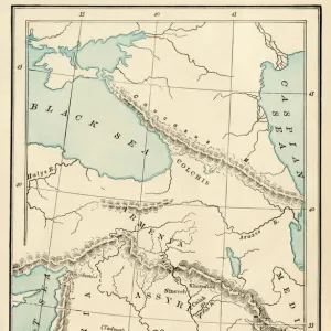
Map of the Battle of Mount Thabor, published by William Blackwood and Sons
746927 Map of the Battle of Mount Thabor, published by William Blackwood and Sons, Edinburgh & London, 1848 (hand-coloured engraving) by Johnston, Alexander Keith (1804-71); Private Collection; (add.info.: Battle of Mount Tabor (April 16, 1799)
); The Stapleton Collection; Scottish, out of copyright
Media ID 22397950
© The Stapleton Collection / Bridgeman Images
Aerial View Armies French Revolutionary Wars Mapping Ottoman Positions
Medium 18" Cushion (46x46cm)
18"x18" (46x46cm) Fibre filled cushion with a plush soft feel. Your choice of image fills the front, with a stone coloured faux suede back. Flat sewn concealed white zip.
Accessorise your space with decorative, soft cushions
Estimated Product Size is 45.7cm x 45.7cm (18" x 18")
These are individually made so all sizes are approximate
Artwork printed orientated as per the preview above, with landscape (horizontal) or portrait (vertical) orientation to match the source image.
FEATURES IN THESE COLLECTIONS
> Aerial Photography
> Related Images
> Aerial Photography
> Scotland
> Arts
> Artists
> A
> William Alexander
> Arts
> Artists
> K
> William Keith
> Arts
> Artists
> S
> Syrian Syrian
> Asia
> Syria
> Related Images
> Fine Art Finder
> Artists
> Alexander Keith Johnston
> Fine Art Finder
> Maps (celestial & Terrestrial)
EDITORS COMMENTS
This print showcases a historical map of the Battle of Mount Thabor, published by William Blackwood and Sons in 1848. The hand-coloured engraving, created by Alexander Keith Johnston, offers a detailed depiction of the battle that took place on April 16,1799. The aerial view presented in this map allows us to visualize the positions and movements of the armies involved in the skirmish. It provides valuable insights into the Egypt-Syria campaign during the French Revolutionary Wars. The clash between French and Ottoman forces is vividly portrayed through meticulous cartography. As we examine this piece closely, we can appreciate both its artistic value and its historical significance. The intricate detailing of each army's placement highlights their strategic maneuvers during this critical engagement. This map serves as an invaluable resource for historians studying military tactics from the early 19th century. Published over a century after the event it depicts, this hand-coloured engraving has withstood time while retaining its allure. Its inclusion in private collections speaks to its enduring appeal among art enthusiasts who are captivated by both cartography and history. Through this print from Fine Art Finder, viewers are transported back in time to witness a pivotal moment in history – one that forever shaped the course of warfare during an era marked by revolution and conflict.
MADE IN THE UK
Safe Shipping with 30 Day Money Back Guarantee
FREE PERSONALISATION*
We are proud to offer a range of customisation features including Personalised Captions, Color Filters and Picture Zoom Tools
SECURE PAYMENTS
We happily accept a wide range of payment options so you can pay for the things you need in the way that is most convenient for you
* Options may vary by product and licensing agreement. Zoomed Pictures can be adjusted in the Basket.