Canvas Print > Sheffield City Archives > Maps and Plans
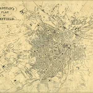
Canvas Print : Sheffield, a new plan of Sheffield reduced from the Ordnance Survey and comprises all the subsequent improvements, new streets etc from 1850 to 1873


![]()
Canvas Prints from Sheffield City Archives
Sheffield, a new plan of Sheffield reduced from the Ordnance Survey and comprises all the subsequent improvements, new streets etc from 1850 to 1873
Published by William White.Scale 6 inches : 1 mile.Original at Local Studies Library: S138L
Sheffield City Archives and Local Studies Library has an unrivalled collection of images of Sheffield, England
Media ID 14047655
© Sheffield City Council
20"x16" (50x40cm) Canvas Print
Step back in time with our exquisite Canvas Print of Sheffield, a historic map from 1850 to 1873. Meticulously reproduced from the original at Sheffield City Archives, this captivating print showcases the city's development with new streets and improvements, as depicted in the Ordnance Survey map published by William White. Each detail is brought to life on premium canvas, creating a stunning piece of art that tells a story of Sheffield's rich history. Add a touch of timeless charm to your home decor with this unique and authentic representation of the past.
Ready to hang Premium Gloss Canvas Print. Our archival quality canvas prints are made from Polyester and Cotton mix and stretched over a 1.25" (32mm) kiln dried knot free wood stretcher bar. Packaged in a plastic bag and secured to a cardboard insert for transit.
Canvas Prints add colour, depth and texture to any space. Professionally Stretched Canvas over a hidden Wooden Box Frame and Ready to Hang
Estimated Product Size is 50.8cm x 40.6cm (20" x 16")
These are individually made so all sizes are approximate
Artwork printed orientated as per the preview above, with landscape (horizontal) orientation to match the source image.
EDITORS COMMENTS
This print showcases Sheffield, a vibrant city in England, as it evolved and flourished between 1850 and 1873. The image is a reproduction of an original map published by William White, meticulously reduced from the Ordnance Survey to capture every intricate detail. With a scale of 6 inches to 1 mile, this comprehensive plan offers an invaluable glimpse into the past. The print encompasses all subsequent improvements made during those eventful years - new streets emerging like arteries through the urban landscape. It serves as a testament to Sheffield's relentless growth and progress during this transformative period. Preserved at the esteemed Local Studies Library within Sheffield City Archives, this historic document holds immense value for researchers, historians, and anyone fascinated by the city's rich heritage. Its presence allows us to retrace footsteps taken long ago on these very streets that have witnessed countless stories unfold. As we gaze upon this remarkable piece of history captured in ink on paper, we are transported back in time. We can almost hear the bustling sounds of horse-drawn carriages traversing cobblestone roads while pedestrians go about their daily lives amidst Victorian architecture. While its commercial use may be restricted due to copyright limitations surrounding maps produced by companies such as Ordnance Survey, its true worth lies in preserving our collective memory and understanding how Sheffield has evolved over time. This print stands as both a tribute to our shared past and an invitation for future generations to explore the ever-changing tapestry of one of England's most dynamic
MADE IN THE UK
Safe Shipping with 30 Day Money Back Guarantee
FREE PERSONALISATION*
We are proud to offer a range of customisation features including Personalised Captions, Color Filters and Picture Zoom Tools
SECURE PAYMENTS
We happily accept a wide range of payment options so you can pay for the things you need in the way that is most convenient for you
* Options may vary by product and licensing agreement. Zoomed Pictures can be adjusted in the Basket.