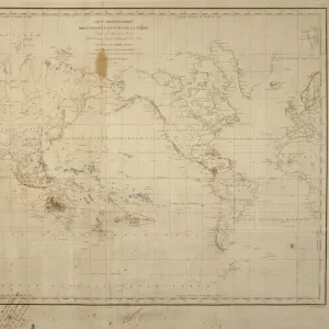
Canvas Print : Moran?s War Map, coloured to show Britain and her Allies


![]()
Canvas Prints from Mary Evans Picture Library
Moran?s War Map, coloured to show Britain and her Allies
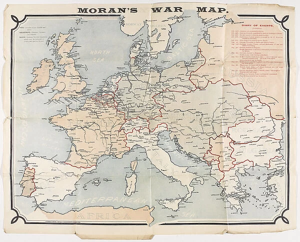
Map: Moran?s War Map, coloured to show Britain and her Allies, Germany and Austria-Hungary, and the neutral nations at the outbreak of the First World War. Created by E Moran and Sons Limited, Sunderland;. Belonged to Pte J Harrison (4308), 3rd Division British Expeditionary Force. Includes notes on the key events from 23 Jul to 12 Aug 1914 which lead to the outbreak of War. Associated with World War One, Outbreak of War (1914). Date: 1914
Mary Evans Picture Library makes available wonderful images created for people to enjoy over the centuries
Media ID 14403988
© The National Army Museum / Mary Evans Picture Library
Allies Austria Belonged Created Division First Harrison Hungary Moran Nations Neutral Outbreak Sons Sunderland
20"x16" (50x40cm) Canvas Print
Step back in time with our exquisite Canvas Prints from Media Storehouse, featuring the captivating "Moran's War Map, coloured to show Britain and her Allies" from Mary Evans Prints Online. This historic map, published at the onset of the First World War, offers a unique and intriguing perspective on the geopolitical landscape of Europe during that era. Colour-coded to distinguish between Britain and her Allies, Germany and Austria-Hungary, and the neutral nations, this detailed map is an essential addition to any history or art enthusiast's collection. Embrace the nostalgia and bring a piece of the past into your home or office with our high-quality Canvas Prints.
Ready to hang Premium Gloss Canvas Print. Our archival quality canvas prints are made from Polyester and Cotton mix and stretched over a 1.25" (32mm) kiln dried knot free wood stretcher bar. Packaged in a plastic bag and secured to a cardboard insert for transit.
Canvas Prints add colour, depth and texture to any space. Professionally Stretched Canvas over a hidden Wooden Box Frame and Ready to Hang
Estimated Product Size is 50.8cm x 40.6cm (20" x 16")
These are individually made so all sizes are approximate
Artwork printed orientated as per the preview above, with landscape (horizontal) orientation to match the source image.
EDITORS COMMENTS
This and historically significant print depicts Moran's War Map, meticulously colored to illustrate the political landscape of Europe at the onset of the First World War. Created by E Moran and Sons Limited in Sunderland, this map was once in the possession of Private J Harrison (4308) of the 3rd Division British Expeditionary Force. The vibrant hues distinguish the territories of Britain and her Allies, including France, Belgium, and Russia, from those of their adversaries, Germany and Austria-Hungary, as well as the neutral nations such as Switzerland and the Netherlands. The map is annotated with key events that transpired between July 23 and August 12, 1914, leading up to the outbreak of war. These notations include the assassination of Archduke Franz Ferdinand of Austria-Hungary, the declaration of war by Germany against Russia, and the subsequent mobilization of the British and French armies. This remarkable artifact offers a unique glimpse into the geopolitical situation of Europe on the brink of war, providing valuable context to the historical events that unfolded during this tumultuous period. The intricate details and meticulous coloring of the map serve as a testament to the skill and craftsmanship of Moran and Sons Limited, making it a valuable addition to any collection focused on World War One or the history of cartography.
MADE IN THE UK
Safe Shipping with 30 Day Money Back Guarantee
FREE PERSONALISATION*
We are proud to offer a range of customisation features including Personalised Captions, Color Filters and Picture Zoom Tools
SECURE PAYMENTS
We happily accept a wide range of payment options so you can pay for the things you need in the way that is most convenient for you
* Options may vary by product and licensing agreement. Zoomed Pictures can be adjusted in the Basket.