Canvas Print : Moa River Railway Bridge, Sierra Leone, West Africa


![]()
Canvas Prints from Mary Evans Picture Library
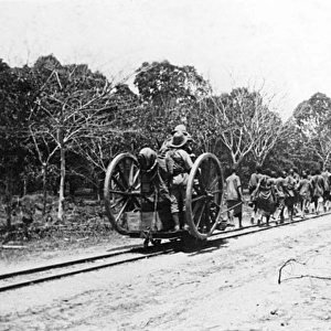
Moa River Railway Bridge, Sierra Leone, West Africa
Moa River Railway Bridge, Sierra Leone, West Africa. Date: circa 1912
Mary Evans Picture Library makes available wonderful images created for people to enjoy over the centuries
Media ID 14407416
© Mary Evans / Pharcide
Bridges Carriages Engineering Leone Sierra
21"x14" (53x35cm) Canvas Print
Introducing the stunning Moa River Railway Bridge Canvas Print from Media Storehouse. This captivating image, sourced from Mary Evans Prints Online, takes you back in time to circa 1912 in Sierra Leone, West Africa. The Moa River Railway Bridge, a marvel of engineering from the past, is beautifully rendered in this high-quality canvas print. Each print is meticulously crafted using premium materials and vibrant inks, ensuring a long-lasting and impressive display. Transport yourself to another era with this evocative and intriguing piece of history.
Ready to hang Premium Gloss Canvas Print. Our archival quality canvas prints are made from Polyester and Cotton mix and stretched over a 1.25" (32mm) kiln dried knot free wood stretcher bar. Packaged in a plastic bag and secured to a cardboard insert for transit.
Canvas Prints add colour, depth and texture to any space. Professionally Stretched Canvas over a hidden Wooden Box Frame and Ready to Hang
Estimated Product Size is 53.3cm x 35.6cm (21" x 14")
These are individually made so all sizes are approximate
Artwork printed orientated as per the preview above, with landscape (horizontal) orientation to match the source image.
EDITORS COMMENTS
1. Title: A Feat of Engineering in the Heart of West Africa - Moa River Railway Bridge, Sierra Leone, Circa 1912 The Moa River Railway Bridge, a marvel of engineering in the early 20th century, stands proudly over the meandering Moa River in Sierra Leone, West Africa. This photograph, taken circa 1912, showcases the bridge's grandeur and the harmonious coexistence of rail and water. The bridge, an essential part of the railway system connecting the Atlantic coast with the interior of the country, was a testament to the ingenuity and determination of the colonial engineers who designed and built it. The bridge's sturdy pillars, anchored firmly into the riverbed, support the iron arches that gracefully span the river, allowing trains to pass through unobstructed. The railway cars, filled with passengers and cargo, are seen making their way across the bridge, their wheels clicking rhythmically against the rails. The tranquil waters of the Moa River mirror the reflection of the bridge, creating a mesmerizing scene that speaks to the harmony between man-made structures and the natural world. The Moa River Railway Bridge was more than just a means of transportation; it was a symbol of progress and development in Sierra Leone during the colonial era. It opened up new opportunities for trade, commerce, and communication, connecting the country to the wider world. The bridge remains an enduring testament to the indomitable spirit of engineering and the resilience of the human spirit in overcoming the challenges of building in a complex and often unforgiving environment. This photograph, a snapshot of history, offers a glimpse into the past, transporting us back to a time when the world was being connected in new and exciting ways, and the wonders of engineering were transforming the landscape of Africa and beyond.
MADE IN THE UK
Safe Shipping with 30 Day Money Back Guarantee
FREE PERSONALISATION*
We are proud to offer a range of customisation features including Personalised Captions, Color Filters and Picture Zoom Tools
SECURE PAYMENTS
We happily accept a wide range of payment options so you can pay for the things you need in the way that is most convenient for you
* Options may vary by product and licensing agreement. Zoomed Pictures can be adjusted in the Basket.