Canvas Print > Arts > Realistic drawings > Still life artwork > Fine art
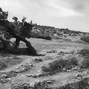
Canvas Print : Map / Asia / Palestine / Bible


![]()
Canvas Prints from Mary Evans Picture Library
Map / Asia / Palestine / Bible
A map of Palestine during the period of Jesuss life there
Mary Evans Picture Library makes available wonderful images created for people to enjoy over the centuries
Media ID 4329427
© Mary Evans Picture Library 2015 - https://copyrighthub.org/s0/hub1/creation/maryevans/MaryEvansPictureID/10063819
20"x16" (50x40cm) Canvas Print
"Bring the rich history of the Holy Land into your home with our stunning Canvas Prints from Media Storehouse. This captivating piece, "Map / Asia / Palestine / Bible" by Rights Managed from Mary Evans Prints Online, showcases an intricately detailed map of Palestine during the time of Jesus' life. Each print is meticulously crafted on high-quality canvas, ensuring vibrant colors and sharp details that truly bring the image to life. Add a touch of history and spirituality to your decor with this beautiful and meaningful addition to your space."
Ready to hang Premium Gloss Canvas Print. Our archival quality canvas prints are made from Polyester and Cotton mix and stretched over a 1.25" (32mm) kiln dried knot free wood stretcher bar. Packaged in a plastic bag and secured to a cardboard insert for transit.
Canvas Prints add colour, depth and texture to any space. Professionally Stretched Canvas over a hidden Wooden Box Frame and Ready to Hang
Estimated Product Size is 40.6cm x 50.8cm (16" x 20")
These are individually made so all sizes are approximate
Artwork printed orientated as per the preview above, with portrait (vertical) orientation to match the source image.
FEATURES IN THESE COLLECTIONS
> Arts
> Realistic drawings
> Still life artwork
> Fine art
> Asia
> Palestine
> Related Images
> Asia
> Related Images
> Maps and Charts
> Early Maps
> Maps and Charts
> Related Images
EDITORS COMMENTS
This print showcases a historical map of Palestine during the period of Jesus's life, providing a fascinating glimpse into the geography of this significant region. The intricate details and accuracy of the map offer viewers a deeper understanding of the landscapes that Jesus would have traversed during his time in Palestine.
The inclusion of key locations mentioned in the Bible adds an extra layer of significance to this map, allowing us to visualize the places where important events from religious texts took place. From Bethlehem to Jerusalem, each city and town depicted on this map holds its own unique history and importance in relation to Jesus's life and teachings.
As we study this detailed representation of ancient Palestine, we are transported back in time to an era filled with religious fervor and cultural richness. The meticulous craftsmanship evident in this map serves as a testament to the enduring legacy of these sacred lands.
Whether you are a history buff, a devout believer, or simply curious about the world during biblical times, this print is sure to spark your imagination and deepen your appreciation for the profound impact that Palestine had on shaping Christianity as we know it today.
MADE IN THE UK
Safe Shipping with 30 Day Money Back Guarantee
FREE PERSONALISATION*
We are proud to offer a range of customisation features including Personalised Captions, Color Filters and Picture Zoom Tools
SECURE PAYMENTS
We happily accept a wide range of payment options so you can pay for the things you need in the way that is most convenient for you
* Options may vary by product and licensing agreement. Zoomed Pictures can be adjusted in the Basket.