Canvas Print > Arts > Artists > T > John Tallis
Canvas Print : Old Map of Africa 1851 by John Tallis


![]()
Canvas Prints from MapSeeker
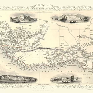
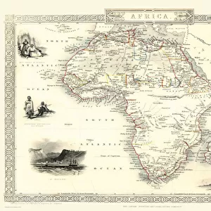
Old Map of Africa 1851 by John Tallis
A fine facimile artworked from an antique original map of the Continent of Africa, issued as part of the 1851 edition of John Tallis and Companys " The Illustrated Atlas and Modern History of the World"
Welcome to the Mapseeker Image library and enter an historic gateway to one of the largest on-line collections of Historic Maps, Nostalgic Views, Vista's and Panorama's from a World gone by.
Media ID 20347382
© Mapseeker Publishing Ltd
Continental Map John Tallis John Tallis Map Old Continental Map Tallis Map
21"x14" (53x35cm) Canvas Print
Step back in time with our exquisite Canvas Print of the Old Map of Africa 1851 by John Tallis and John Rapkin from MapSeeker. This stunning reproduction is a fine facsimile of the antique original map, taken from the renowned 1851 edition of John Tallis's "The Illustrated Atlas". Each detail of the intricately drawn map is beautifully rendered on premium canvas, bringing the history and character of this iconic cartographic masterpiece into your home or office. Embrace the rich heritage of cartography and add a touch of timeless elegance to your space with our Old Map of Africa Canvas Print.
Ready to hang Premium Gloss Canvas Print. Our archival quality canvas prints are made from Polyester and Cotton mix and stretched over a 1.25" (32mm) kiln dried knot free wood stretcher bar. Packaged in a plastic bag and secured to a cardboard insert for transit.
Canvas Prints add colour, depth and texture to any space. Professionally Stretched Canvas over a hidden Wooden Box Frame and Ready to Hang
Estimated Product Size is 53.3cm x 35.6cm (21" x 14")
These are individually made so all sizes are approximate
Artwork printed orientated as per the preview above, with landscape (horizontal) orientation to match the source image.
FEATURES IN THESE COLLECTIONS
> Arts
> Artists
> T
> John Tallis
> Maps and Charts
> Related Images
> Maps and Charts
> World
> MapSeeker
> Maps of Africa and Oceana
> Old Maps Showing the Continent of
EDITORS COMMENTS
This print showcases an exquisite piece of cartographic history - the "Old Map of Africa 1851" by John Tallis. Crafted as a faithful facsimile artwork from an antique original map, this masterpiece was originally issued as part of the renowned 1851 edition of John Tallis and Company's "The Illustrated Atlas and Modern History of the World". Transporting us back in time, this vintage map offers a glimpse into Africa's past, capturing its diverse landscapes, intricate coastlines, and enchanting topography. With meticulous attention to detail, John Tallis skillfully depicts each region with precision and artistry. As we explore this old African map, we are reminded of the continent's rich history and cultural heritage. From ancient civilizations to colonial influences, every corner tells a story waiting to be discovered. The names of long-forgotten kingdoms and cities grace its surface like whispers from centuries gone by. John Rapkin's collaboration with John Tallis further enhances this remarkable work. Together they have created a visual treasure that not only serves as a navigational tool but also evokes curiosity about Africa's past. Whether you are an avid collector or simply captivated by historical artifacts, this print is sure to become a cherished addition to your collection. Display it proudly on your wall or use it as inspiration for future adventures across the vast continent that is Africa.
MADE IN THE UK
Safe Shipping with 30 Day Money Back Guarantee
FREE PERSONALISATION*
We are proud to offer a range of customisation features including Personalised Captions, Color Filters and Picture Zoom Tools
SECURE PAYMENTS
We happily accept a wide range of payment options so you can pay for the things you need in the way that is most convenient for you
* Options may vary by product and licensing agreement. Zoomed Pictures can be adjusted in the Basket.