Canvas Print > Europe > United Kingdom > England > London > Art > Theatre
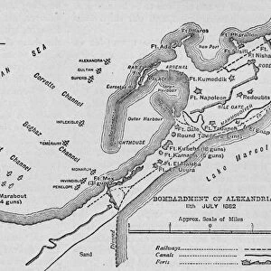
Canvas Print : Map illustrating the Campaigns in Egypt from February, 1915, to May, 1916, . Creator: Unknown


![]()
Canvas Prints from Heritage Images
Map illustrating the Campaigns in Egypt from February, 1915, to May, 1916, . Creator: Unknown
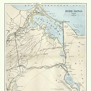
Map illustrating the Campaigns in Egypt from February, 1915, to May, 1916, (c1920). Alexandria and the Nile delta, Cairo, Port Said, the Suez Canal and the Sinai Peninsula during the First World War. From " The Great World War: A History", Volume V, edited by Frank A Mumby. [The Gresham Publishing Company Ltd, London, c1920]
Heritage Images features heritage image collections
Media ID 19665751
© The Print Collector/Heritage Images
Alexandria Alexandria Egypt Cairo Cairo Egypt Canal Frank A Frank A Mumby Frank Arthur Frank Arthur Mumby Gresham Publishing Co Ltd Gresham Publishing Company Keystone Archives Mediterranean Sea Mumby Mumby Frank A Mumby Frank Arthur Nile Nile Delta North Africa Ottoman Empire Port Said River Nile Sinai Sinai Egypt Sinai Peninsula Suez Canal The Great World War A History The Nile Theatre Of War
21"x14" (53x35cm) Canvas Print
Step back in time with our exclusive Media Storehouse Canvas Print featuring an intriguing historical map. This captivating illustration, sourced from Heritage Images, depicts the campaigns in Egypt during the First World War from February 1915 to May 1916. Witness the strategic locations of Alexandria, Cairo, Port Said, the Suez Canal, and the Sinai Peninsula as they were affected by the conflict. Add an element of history and intrigue to your space with this beautifully detailed, unknown creator's work, expertly printed on high-quality canvas for a vibrant and long-lasting display.
Ready to hang Premium Gloss Canvas Print. Our archival quality canvas prints are made from Polyester and Cotton mix and stretched over a 1.25" (32mm) kiln dried knot free wood stretcher bar. Packaged in a plastic bag and secured to a cardboard insert for transit.
Canvas Prints add colour, depth and texture to any space. Professionally Stretched Canvas over a hidden Wooden Box Frame and Ready to Hang
Estimated Product Size is 53.3cm x 35.6cm (21" x 14")
These are individually made so all sizes are approximate
Artwork printed orientated as per the preview above, with landscape (horizontal) orientation to match the source image.
FEATURES IN THESE COLLECTIONS
> Africa
> Egypt
> Alexandria
> Africa
> Egypt
> Related Images
> Africa
> Related Images
> Animals
> Mammals
> Muridae
> Water Mouse
> Arts
> Landscape paintings
> Waterfall and river artworks
> River artworks
> Europe
> United Kingdom
> England
> London
> Art
> Theatre
Map illustrating the Campaigns in Egypt from February, 1915, to May, 1916
EDITORS COMMENTS
. This print takes us back to the turbulent times of the First World War. The map showcases a crucial theater of war - Egypt - during the period between February 1915 and May 1916. Created by an unknown artist and featured in "The Great World War: A History" this historical artifact offers a glimpse into the strategic importance of Alexandria and its surrounding regions. The intricate details on this map highlight key geographical features such as Cairo, Port Said, the Suez Canal, and the Sinai Peninsula. These locations played vital roles in transportation routes for both sides involved in the conflict. As we observe this piece closely, it becomes evident that it was meticulously crafted to aid military planning during those challenging times. The image also reminds us of Egypt's significant position within the vast Ottoman Empire at that time. The Nile River dominates much of this map, symbolizing lifeblood amidst chaos. It serves as a reminder that even amid war-torn landscapes, nature continues to flow steadily. As we reflect on this photograph print from Heritage Images' collection curated by Frank A Mumby for Gresham Publishing Company Ltd. , let us appreciate how history unfolds through maps like these – capturing moments frozen in time while offering valuable insights into past conflicts and their impact on nations worldwide.
MADE IN THE UK
Safe Shipping with 30 Day Money Back Guarantee
FREE PERSONALISATION*
We are proud to offer a range of customisation features including Personalised Captions, Color Filters and Picture Zoom Tools
SECURE PAYMENTS
We happily accept a wide range of payment options so you can pay for the things you need in the way that is most convenient for you
* Options may vary by product and licensing agreement. Zoomed Pictures can be adjusted in the Basket.