Canvas Print > Europe > France > Canton > Meurthe
Canvas Print : Map of the Battle of Vionville, 16 August 1870, (c1872). Creator: R. Walker
. Creator: R. Walker")
. Creator: R. Walker")


![]()
Canvas Prints from Heritage Images
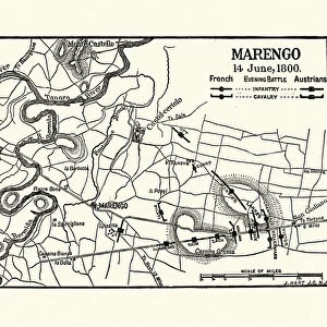
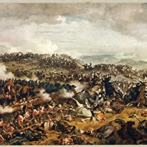
Map of the Battle of Vionville, 16 August 1870, (c1872). Creator: R. Walker
Map of the Battle of Vionville, 16 August 1870, (c1872). Map: Drawn under the Superintendance of Captain Hozier, showing the enemy positions. The Battle of Mars-La-Tour (also known as the Battle of Vionville or Battle of Rezonville) was fought near the village of Mars-La-Tour in northeast France. From " The Franco-Prussian War: its causes, incidents and consequences", Volume I, by Captain H M Hozier. [William Mackenzie, London, 1872]
Heritage Images features heritage image collections
Media ID 19778779
© The Print Collector/Heritage Images
1870 1871 Bamp W Franco Prussian War Front Line Frontline Grand Est H M Hozier Henry Montague Henry Montague Hozier Hozier Lines Lorraine Mackenzie Metz Meurthe Et Moselle Mosel Moselle R Walker River Mosel Robert Walker Sir Henry Montagu Hozier Walker William Mackenzie Battlefield Mars La Tour Siege Of Metz
21"x14" (53x35cm) Canvas Print
Step back in time with our stunning Canvas Print of the Battle of Vionville Map (1872), captured by R. Walker from Heritage Images. This intricately detailed map, drawn under the superintendance of Captain Hozier, offers a captivating glimpse into the strategic positions of the opposing forces during the Battle of Vionville on August 16, 1870. Bring history to life in your home or office with this unique and authentic piece of art. Perfect for history enthusiasts, military collectors, or anyone who appreciates the beauty of historical maps. Order your Canvas Print today and let the story unfold.
Ready to hang Premium Gloss Canvas Print. Our archival quality canvas prints are made from Polyester and Cotton mix and stretched over a 1.25" (32mm) kiln dried knot free wood stretcher bar. Packaged in a plastic bag and secured to a cardboard insert for transit.
Canvas Prints add colour, depth and texture to any space. Professionally Stretched Canvas over a hidden Wooden Box Frame and Ready to Hang
Estimated Product Size is 53.3cm x 35.6cm (21" x 14")
These are individually made so all sizes are approximate
Artwork printed orientated as per the preview above, with landscape (horizontal) orientation to match the source image.
FEATURES IN THESE COLLECTIONS
> Arts
> Artists
> W
> Robert Walker
> Arts
> Artists
> W
> Robert White
> Arts
> Artists
> W
> William White
> Arts
> Landscape paintings
> Waterfall and river artworks
> River artworks
> Europe
> France
> Canton
> Meurthe
> Europe
> France
> Canton
> Moselle
EDITORS COMMENTS
This print captures a detailed map of the Battle of Vionville, which took place on 16 August 1870 during the Franco-Prussian War. Created by R. Walker and drawn under the supervision of Captain Hozier, this map provides a comprehensive overview of enemy positions during this significant battle. The Battle of Vionville, also known as the Battle of Mars-La-Tour or Battle of Rezonville, occurred near the village of Mars-La-Tour in northeast France. This historic conflict is depicted with precision on this map, showcasing key geographical features such as cities, rivers, towns, and lines that played crucial roles in determining military strategies. As we delve into this intricate depiction from Volume I of "The Franco-Prussian War: its causes, incidents and consequences" by Captain H M Hozier (published by William Mackenzie in London in 1872), we are transported back to the 19th century battlefield where intense warfare unfolded. The print collector Robert Walker has skillfully captured every detail necessary for understanding the historical significance and impact of this battle. With its striking monochromatic aesthetic and meticulous attention to detail, this print serves as a valuable resource for historians studying not only military tactics but also the geography and locations associated with major battles like Vionville. It offers viewers an opportunity to explore one chapter within a larger narrative that shaped Europe's history during that era - an enduring testament to human conflict and resilience.
MADE IN THE UK
Safe Shipping with 30 Day Money Back Guarantee
FREE PERSONALISATION*
We are proud to offer a range of customisation features including Personalised Captions, Color Filters and Picture Zoom Tools
SECURE PAYMENTS
We happily accept a wide range of payment options so you can pay for the things you need in the way that is most convenient for you
* Options may vary by product and licensing agreement. Zoomed Pictures can be adjusted in the Basket.