Canvas Print > Granger Art on Demand > Plans and Diagrams
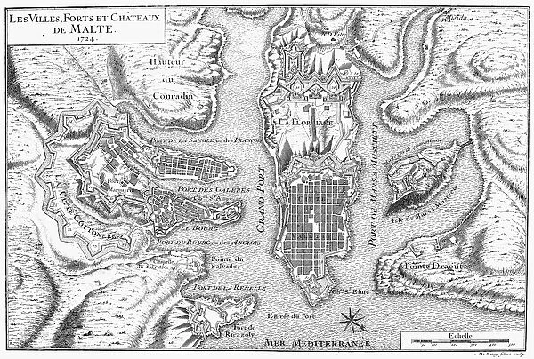
Canvas Print : Plan of the city and harbor of Valletta and environs, showing the fortifications existing in 1724. Copper engraving, French, 1728


![]()
Canvas Prints from Granger
Plan of the city and harbor of Valletta and environs, showing the fortifications existing in 1724. Copper engraving, French, 1728
MALTA: VALETTA MAP, 1724.
Plan of the city and harbor of Valletta and environs, showing the fortifications existing in 1724. Copper engraving, French, 1728
Granger holds millions of images spanning more than 25,000 years of world history, from before the Stone Age to the dawn of the Space Age
Media ID 10407728
1724 1728 Fort Harbor Mediterranean Plan Valletta
21"x14" (53x35cm) Canvas Print
Step back in time with our exquisite Canvas Print of the historical map of Valletta, Malta. This stunning reproduction, taken from the original copper engraving dated 1728, showcases an intricate plan of the city and harbor of Valletta and its fortifications as they existed in 1724. With meticulous detail, you can explore the layout of the ancient city walls, forts, and harbor. Bring a piece of history into your home or office with this beautiful and authentic work of art from Media Storehouse and Granger Art on Demand.
Ready to hang Premium Gloss Canvas Print. Our archival quality canvas prints are made from Polyester and Cotton mix and stretched over a 1.25" (32mm) kiln dried knot free wood stretcher bar. Packaged in a plastic bag and secured to a cardboard insert for transit.
Canvas Prints add colour, depth and texture to any space. Professionally Stretched Canvas over a hidden Wooden Box Frame and Ready to Hang
Estimated Product Size is 53.3cm x 35.6cm (21" x 14")
These are individually made so all sizes are approximate
Artwork printed orientated as per the preview above, with landscape (horizontal) orientation to match the source image.
EDITORS COMMENTS
This print showcases a detailed and intricate plan of the city and harbor of Valletta, along with its surrounding areas, as it appeared in 1724. Created through the meticulous artistry of copper engraving by French craftsmen in 1728, this historical piece offers a glimpse into the past glory of Malta's capital. The fortifications depicted on this map highlight the strategic importance of Valletta during that era. With its prime location in the Mediterranean Sea, Valletta served as a vital stronghold for maritime defense and trade routes. The engravings beautifully capture the architectural prowess of these forts, showcasing their formidable presence against an idyllic backdrop. As we delve into this visual treasure trove, we are transported back to a time when bustling streets lined with charming buildings coexisted harmoniously with mighty fortresses guarding against potential threats from land or sea. The precision and attention to detail evident in every line and curve reflect not only artistic mastery but also serve as testament to the significance placed upon protecting this vibrant city. Whether you are an enthusiast of history or simply captivated by exquisite craftsmanship, this print is sure to transport you to another era. It serves as a reminder that beneath modern developments lie layers upon layers of rich heritage waiting to be explored and appreciated.
MADE IN THE UK
Safe Shipping with 30 Day Money Back Guarantee
FREE PERSONALISATION*
We are proud to offer a range of customisation features including Personalised Captions, Color Filters and Picture Zoom Tools
FREE COLORIZATION SERVICE
You can choose advanced AI Colorization for this picture at no extra charge!
SECURE PAYMENTS
We happily accept a wide range of payment options so you can pay for the things you need in the way that is most convenient for you
* Options may vary by product and licensing agreement. Zoomed Pictures can be adjusted in the Basket.