Canvas Print > North America > United States of America > New York > New York > Maps
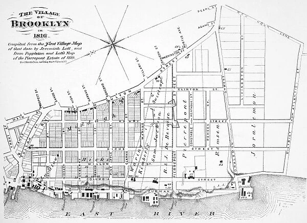
Canvas Print : Map of the village of Brooklyn, New York, in 1816


![]()
Canvas Prints from Granger
Map of the village of Brooklyn, New York, in 1816
BROOKLYN MAP, 1816.
Map of the village of Brooklyn, New York, in 1816
Granger holds millions of images spanning more than 25,000 years of world history, from before the Stone Age to the dawn of the Space Age
Media ID 10408798
1816 Brooklyn Plan Topography United States
20"x16" (50x40cm) Canvas Print
"Bring history into your home with our exquisite Canvas Print of "Map of the village of Brooklyn, New York, in 1816" by 140_1660354 from Granger Art on Demand. This captivating piece showcases a detailed map of the quaint village of Brooklyn as it appeared over 200 years ago. The high-quality canvas print is meticulously crafted to bring out the intricate details of the map, transporting you back in time. Add a touch of history and character to your decor with this unique and fascinating art piece."
Ready to hang Premium Gloss Canvas Print. Our archival quality canvas prints are made from Polyester and Cotton mix and stretched over a 1.25" (32mm) kiln dried knot free wood stretcher bar. Packaged in a plastic bag and secured to a cardboard insert for transit.
Canvas Prints add colour, depth and texture to any space. Professionally Stretched Canvas over a hidden Wooden Box Frame and Ready to Hang
Estimated Product Size is 50.8cm x 40.6cm (20" x 16")
These are individually made so all sizes are approximate
Artwork printed orientated as per the preview above, with landscape (horizontal) orientation to match the source image.
FEATURES IN THESE COLLECTIONS
> Maps and Charts
> Early Maps
> Maps and Charts
> Related Images
> North America
> United States of America
> New York
> New York
> Brooklyn
> Related Images
> North America
> United States of America
> New York
> New York
> Maps
> North America
> United States of America
> New York
> Related Images
> Granger Art on Demand
> Plans and Diagrams
EDITORS COMMENTS
This print showcases a remarkable piece of history - the map of the village of Brooklyn, New York, in 1816. A true treasure for history enthusiasts and lovers of vintage cartography, this map offers a fascinating glimpse into the early days of one of America's most iconic cities. With intricate details and meticulous craftsmanship, this topographical plan captures the essence of Brooklyn as it stood nearly two centuries ago. The streets are neatly laid out, revealing the city's evolving urban landscape. The North River (now known as the Hudson River) gracefully winds its way along the edge, reminding us of Brooklyn's close proximity to waterways that have played a significant role in its development. As we study this map closely, we can't help but imagine what life was like during those times - horse-drawn carriages traversing cobblestone streets, bustling markets filled with merchants and traders from all walks of life. It serves as a visual time capsule that transports us back to an era when Brooklyn was still emerging as a vibrant community within the United States. Whether you're a native New Yorker or simply fascinated by American history, this stunning print is sure to spark curiosity and ignite conversations about how our cities have evolved over time. Hang it proudly on your wall or gift it to someone who appreciates artful representations of our past – either way; it will undoubtedly become an intriguing centerpiece in any space.
MADE IN THE UK
Safe Shipping with 30 Day Money Back Guarantee
FREE PERSONALISATION*
We are proud to offer a range of customisation features including Personalised Captions, Color Filters and Picture Zoom Tools
SECURE PAYMENTS
We happily accept a wide range of payment options so you can pay for the things you need in the way that is most convenient for you
* Options may vary by product and licensing agreement. Zoomed Pictures can be adjusted in the Basket.