Canvas Print > Europe > France > Paris > Maps
Canvas Print : MAP OF ENGLAND, c1250. One of the earliest detailed maps of Great Britain extant


![]()
Canvas Prints from Granger
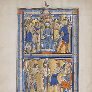
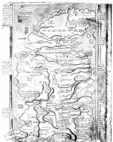
MAP OF ENGLAND, c1250. One of the earliest detailed maps of Great Britain extant
MAP OF ENGLAND, c1250.
One of the earliest detailed maps of Great Britain extant, drawn about 1250 A.D. by Matthew Paris, artist, historian and monk of St. Albans. Features emphasized are the two Roman walls, rivers, towns and the monastery of St. Albans ( cenobium Sancti Albani )
Granger holds millions of images spanning more than 25,000 years of world history, from before the Stone Age to the dawn of the Space Age
Media ID 12321022
1250 Alban Matthew Monastery Paris Saint
20"x16" (50x40cm) Canvas Print
Step back in time with our exquisite Canvas Print of the "Map of England, c1250" from Granger Art on Demand. This ancient masterpiece, created around 1250 A.D. by Matthew Paris, offers a fascinating glimpse into the early history of Great Britain. As one of the earliest detailed maps of the region known to exist, it showcases the intricate details of England's geography during the medieval period. Bring this piece of historical art into your home and add an element of timeless charm to any room. Order your Canvas Print today and embark on a journey through history.
Ready to hang Premium Gloss Canvas Print. Our archival quality canvas prints are made from Polyester and Cotton mix and stretched over a 1.25" (32mm) kiln dried knot free wood stretcher bar. Packaged in a plastic bag and secured to a cardboard insert for transit.
Canvas Prints add colour, depth and texture to any space. Professionally Stretched Canvas over a hidden Wooden Box Frame and Ready to Hang
Estimated Product Size is 40.6cm x 50.8cm (16" x 20")
These are individually made so all sizes are approximate
Artwork printed orientated as per the preview above, with portrait (vertical) orientation to match the source image.
FEATURES IN THESE COLLECTIONS
> Arts
> Art Movements
> Medieval Art
> Arts
> Artists
> R
> Roman Roman
> Arts
> Photorealistic artworks
> Detailed art pieces
> Masterful detailing in art
> Europe
> France
> Paris
> Maps
> Europe
> United Kingdom
> England
> Maps
> Europe
> United Kingdom
> England
> Rivers
> Europe
> United Kingdom
> England
> St Albans
> Maps and Charts
> Related Images
> Granger Art on Demand
> Maps
EDITORS COMMENTS
This print showcases a remarkable piece of history - the "Map of England, c1250". Crafted by Matthew Paris, an esteemed artist, historian, and monk from St. Albans, this map is regarded as one of the earliest detailed depictions of Great Britain that still exists today. Created around 1250 A. D. , it offers a fascinating glimpse into the medieval landscape. The map highlights several notable features with great precision. The two Roman walls are prominently displayed, serving as enduring reminders of Britain's ancient past. Rivers meander across the map, illustrating their significance in shaping the country's geography and providing vital transportation routes. Towns dotting the landscape indicate bustling centers of commerce and human activity during that era. Of particular interest is the inclusion of St. Albans Monastery (cenobium Sancti Albani). This renowned religious institution holds immense historical importance and was likely a source of pride for Matthew Paris himself as a monk from St. Albans. As we delve into this extraordinary artifact from centuries ago, we gain insight into both English history and cartography during medieval times. Its meticulous details offer us a window into how people perceived their world back then - an invaluable resource for scholars and enthusiasts alike.
MADE IN THE UK
Safe Shipping with 30 Day Money Back Guarantee
FREE PERSONALISATION*
We are proud to offer a range of customisation features including Personalised Captions, Color Filters and Picture Zoom Tools
SECURE PAYMENTS
We happily accept a wide range of payment options so you can pay for the things you need in the way that is most convenient for you
* Options may vary by product and licensing agreement. Zoomed Pictures can be adjusted in the Basket.