Canvas Print > Europe > Netherlands > Maps
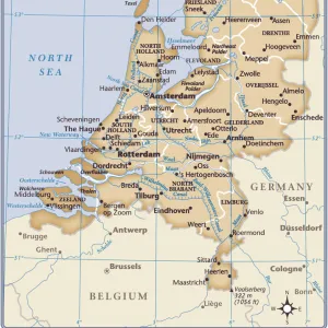
Canvas Print : THE HAGUE: MAP, c1650. Engraved map of the city of The Hague in the Netherlands, c1650, showing canals, fields, gardens, plantations and windmills


![]()
Canvas Prints from Granger
THE HAGUE: MAP, c1650. Engraved map of the city of The Hague in the Netherlands, c1650, showing canals, fields, gardens, plantations and windmills
Granger holds millions of images spanning more than 25,000 years of world history, from before the Stone Age to the dawn of the Space Age
Media ID 6616281
1650 Cartouche Dutch Field Garden Hague Holland Netherlands Plantation Wind Mill
20"x16" (50x40cm) Canvas Print
Step back in time with our exquisite Canvas Print of "The Hague: Map, c1650" from The Granger Collection. This captivating engraving, dating back to the 17th century, offers a breathtaking view of The Hague in the Netherlands. Witness the intricate detail of the city's canals, lush gardens, sprawling plantations, and iconic windmills. The perfect addition to your home or office, this Canvas Print not only showcases historical accuracy but also adds a touch of timeless beauty to your space. Bring the rich history of The Hague into your home with our high-quality, museum-grade Canvas Prints. #HistoricalArt #TheHague #CanvasPrints #GrangerCollection
Ready to hang Premium Gloss Canvas Print. Our archival quality canvas prints are made from Polyester and Cotton mix and stretched over a 1.25" (32mm) kiln dried knot free wood stretcher bar. Packaged in a plastic bag and secured to a cardboard insert for transit.
Canvas Prints add colour, depth and texture to any space. Professionally Stretched Canvas over a hidden Wooden Box Frame and Ready to Hang
Estimated Product Size is 50.8cm x 40.6cm (20" x 16")
These are individually made so all sizes are approximate
Artwork printed orientated as per the preview above, with landscape (horizontal) orientation to match the source image.
FEATURES IN THESE COLLECTIONS
> Europe
> Netherlands
> The Hague
> Europe
> Netherlands
> Maps
> Europe
> Netherlands
> Posters
> Europe
> Netherlands
> Related Images
> Maps and Charts
> Netherlands
> Maps and Charts
> Related Images
> Granger Art on Demand
> Maps
EDITORS COMMENTS
This print takes us back in time to the city of The Hague in the Netherlands during the 17th century. The engraved map, created around 1650, provides a detailed depiction of this historic city and its surroundings. As we gaze upon it, we are transported to an era where canals were bustling with activity, fields stretched out as far as the eye could see, and windmills dotted the landscape. The intricate engraving showcases not only the physical layout of The Hague but also highlights its natural beauty. Gardens and plantations are meticulously illustrated, giving us a glimpse into the lush greenery that adorned this Dutch city centuries ago. The presence of windmills on this map is particularly intriguing. These iconic structures served multiple purposes during that time period – from grinding grain to pumping water – and played a vital role in shaping daily life for residents of The Hague. As we explore every detail within this enchanting image, it becomes evident that this piece is more than just a map; it is a window into history. It allows us to appreciate how cities evolve over time while preserving their unique charm and character. This remarkable print from Granger Art on Demand captures not only our imagination but also serves as a reminder of how art can transport us through time and space.
MADE IN THE UK
Safe Shipping with 30 Day Money Back Guarantee
FREE PERSONALISATION*
We are proud to offer a range of customisation features including Personalised Captions, Color Filters and Picture Zoom Tools
SECURE PAYMENTS
We happily accept a wide range of payment options so you can pay for the things you need in the way that is most convenient for you
* Options may vary by product and licensing agreement. Zoomed Pictures can be adjusted in the Basket.