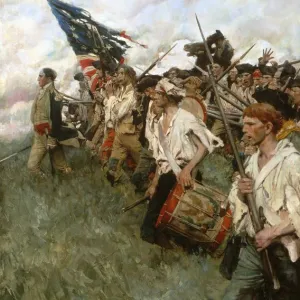
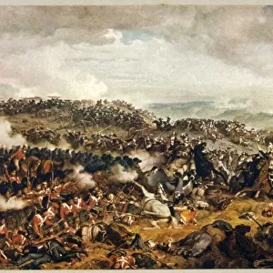
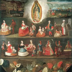
Canvas Print > Historic > Colonial America illustrations > Colonial America
Canvas Print : Map of Williamsburg, Virginia, and the surrounding country. Drawing, 1781, by Louis Alexandre Berthier, an aide to General Rochambeau


![]()
Canvas Prints from Granger
Map of Williamsburg, Virginia, and the surrounding country. Drawing, 1781, by Louis Alexandre Berthier, an aide to General Rochambeau
WILLIAMSBURG: MAP, 1781.
Map of Williamsburg, Virginia, and the surrounding country. Drawing, 1781, by Louis Alexandre Berthier, an aide to General Rochambeau
Granger holds millions of images spanning more than 25,000 years of world history, from before the Stone Age to the dawn of the Space Age
Media ID 7964925
1781 Alexandre American Revolution Colonial Louis Plan Revolutionary War South East Town United States Virginia Williamsburg Yorktown Berthier
21"x14" (53x35cm) Canvas Print
"Bring historical charm into your home with our Canvas Print of the Map of Williamsburg, Virginia, and the surrounding country from 1781. This exquisite drawing, created by Louis Alexandre Berthier, an aide to General Rochambeau, is now available as a stunning canvas print through Media Storehouse. The intricate details of the map, held in The Granger Collection in New York, come alive in vibrant colors and textures, making it a captivating conversation starter. Travel back in time and add a touch of history to your space with this beautiful canvas print."
Ready to hang Premium Gloss Canvas Print. Our archival quality canvas prints are made from Polyester and Cotton mix and stretched over a 1.25" (32mm) kiln dried knot free wood stretcher bar. Packaged in a plastic bag and secured to a cardboard insert for transit.
Canvas Prints add colour, depth and texture to any space. Professionally Stretched Canvas over a hidden Wooden Box Frame and Ready to Hang
Estimated Product Size is 35.6cm x 53.3cm (14" x 21")
These are individually made so all sizes are approximate
Artwork printed orientated as per the preview above, with portrait (vertical) orientation to match the source image.
FEATURES IN THESE COLLECTIONS
> Historic
> Colonial America illustrations
> Colonial America
> Maps and Charts
> Related Images
> South America
> Related Images
> Granger Art on Demand
> American Revolution
EDITORS COMMENTS
This print showcases a historic treasure - the "Map of Williamsburg, Virginia, and the surrounding country" drawn in 1781 by Louis Alexandre Berthier. As an aide to General Rochambeau during the American Revolutionary War, Berthier meticulously crafted this detailed plan of Williamsburg. The map offers a fascinating glimpse into colonial America's past, depicting the late town of Williamsburg as it stood over two centuries ago. Its intricate lines and markings reveal key landmarks and streets that once bustled with activity. This snapshot from history allows us to envision what life was like during this pivotal time in our nation's development. Berthier's map holds particular significance due to its connection with Yorktown, where one of the most decisive battles of the American Revolution took place. It serves as a reminder of how French forces played a crucial role in supporting their American allies against British rule. As we admire this remarkable piece from The Granger Collection, New York / The Granger Collection's Carousel collection, let us appreciate not only its artistic value but also its historical importance. It is through such artifacts that we can better understand our roots and honor those who fought for our freedom.
MADE IN THE UK
Safe Shipping with 30 Day Money Back Guarantee
FREE PERSONALISATION*
We are proud to offer a range of customisation features including Personalised Captions, Color Filters and Picture Zoom Tools
SECURE PAYMENTS
We happily accept a wide range of payment options so you can pay for the things you need in the way that is most convenient for you
* Options may vary by product and licensing agreement. Zoomed Pictures can be adjusted in the Basket.