Canvas Print > Fine Art Storehouse > Map
Canvas Print : Map Of Britain


![]()
Canvas Prints from Fine Art Storehouse
Map Of Britain
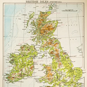
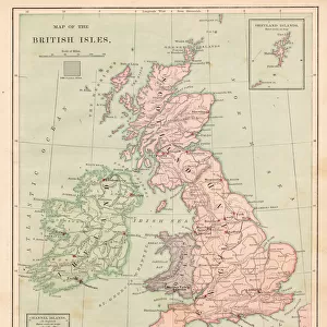
A map of the British Isles from Theatrum Orbis Terrarum, by J Blaen, published 1645. (Photo by Hulton Archive/Getty Images)
Unleash your creativity and transform your space into a visual masterpiece!
Hulton Archive
Media ID 11799698
© 2005 Getty Images
15697 Britain Earlydate Engravings Prints Diry Format
20"x16" (50x40cm) Canvas Print
Discover the rich history of Britain with our exquisite Map Of Britain Canvas Print from the Media Storehouse Fine Art Storehouse collection. This magnificent piece, derived from Theatrum Orbis Terrarum by J Blaen, published in 1645, showcases intricate details of the British Isles as they appeared over 375 years ago. The vintage map, captured by Hulton Archive, is expertly printed on high-quality canvas, ensuring vibrant colors and sharp detail. Bring history into your home and transport yourself back in time with this stunning and conversation-starting addition to your decor.
Ready to hang Premium Gloss Canvas Print. Our archival quality canvas prints are made from Polyester and Cotton mix and stretched over a 1.25" (32mm) kiln dried knot free wood stretcher bar. Packaged in a plastic bag and secured to a cardboard insert for transit.
Canvas Prints add colour, depth and texture to any space. Professionally Stretched Canvas over a hidden Wooden Box Frame and Ready to Hang
Estimated Product Size is 50.8cm x 40.6cm (20" x 16")
These are individually made so all sizes are approximate
Artwork printed orientated as per the preview above, with landscape (horizontal) orientation to match the source image.
FEATURES IN THESE COLLECTIONS
> Fine Art Storehouse
> Map
> Historical Maps
> Fine Art Storehouse
> Photo Libraries
> Heritage Images
EDITORS COMMENTS
This print showcases a historical gem, the "Map of Britain" from Theatrum Orbis Terrarum, published in 1645. Brought to life by J Blaen's skilled craftsmanship, this exquisite map offers a fascinating glimpse into the British Isles during that era. With its intricate details and delicate engravings, it transports us back in time to an age where exploration and cartography were at their peak. The landscape format of this print allows for every inch of the map to be appreciated, revealing England's rich history and its connection with Europe. As we study each contour line and carefully placed label, we can't help but marvel at how much our world has changed since then. Displayed within a sturdy box frame, this fine art piece is perfect for those who appreciate both history and aesthetics. Whether you're an avid collector or simply seeking a conversation starter for your home or office space, this print will undoubtedly captivate all who lay eyes upon it. With its early date and timeless appeal, this Map of Britain serves as more than just decoration; it is a testament to human curiosity and our unending quest for knowledge about the world around us. Let it transport you back in time while also reminding you of the ever-evolving nature of our planet.
MADE IN THE UK
Safe Shipping with 30 Day Money Back Guarantee
FREE PERSONALISATION*
We are proud to offer a range of customisation features including Personalised Captions, Color Filters and Picture Zoom Tools
SECURE PAYMENTS
We happily accept a wide range of payment options so you can pay for the things you need in the way that is most convenient for you
* Options may vary by product and licensing agreement. Zoomed Pictures can be adjusted in the Basket.