Canvas Print > Arts > Street art graffiti > Digital art > Digital paintings
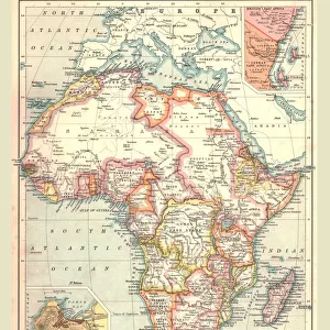
Canvas Print : The world in 1900 showing how it was governed by different nations


![]()
Canvas Prints from Fine Art Storehouse
The world in 1900 showing how it was governed by different nations
Digital illustration of the world in 1900 showing how it was governed by different nations
Unleash your creativity and transform your space into a visual masterpiece!
Dorling Kindersley
Media ID 13541105
© This content is subject to copyright
1900 20th Century 20th Century Style Variation Western Script World Map Digitally Generated Digitally Generated Image
21"x14" (53x35cm) Canvas Print
"Step back in time with our stunning Canvas Print from Media Storehouse and Dorling Kindersley's Fine Art Storehouse. This captivating digital illustration portrays the world in 1900, meticulously depicting how it was governed by various nations. Add an intriguing conversation starter and a touch of history to your space with this beautiful, high-quality Canvas Print. Experience the rich tapestry of global history right in your home."
Ready to hang Premium Gloss Canvas Print. Our archival quality canvas prints are made from Polyester and Cotton mix and stretched over a 1.25" (32mm) kiln dried knot free wood stretcher bar. Packaged in a plastic bag and secured to a cardboard insert for transit.
Canvas Prints add colour, depth and texture to any space. Professionally Stretched Canvas over a hidden Wooden Box Frame and Ready to Hang
Estimated Product Size is 53.3cm x 35.6cm (21" x 14")
These are individually made so all sizes are approximate
Artwork printed orientated as per the preview above, with landscape (horizontal) orientation to match the source image.
FEATURES IN THESE COLLECTIONS
> Animals
> Mammals
> Muridae
> Western Mouse
> Arts
> Street art graffiti
> Digital art
> Digital paintings
> Maps and Charts
> Related Images
> Maps and Charts
> World
> Fine Art Storehouse
> Photo Libraries
> Dorling Kindersley Prints
EDITORS COMMENTS
This digital illustration takes us back to the year 1900, providing a visual representation of how the world was governed by different nations during that time. The artist skillfully combines elements of cartography and cut-out techniques to create a stunning piece that showcases the geopolitical landscape of the past. The horizontal composition allows for easy exploration of this intricate artwork, which is devoid of any human presence. Against a clean white background, the world map takes center stage, with its vibrant colors and detailed borders indicating various territories controlled by different countries. In true 20th-century style, this digitally generated image captures the essence of an era when Western script dominated global governance. Each nation's name is meticulously labeled in clear typography, highlighting their distinct identities on this historical map. As we observe this studio shot print from Dorling Kindersley's collection at Fine Art Storehouse, it becomes evident that it serves as more than just decorative wall art. It invites viewers to reflect upon our shared history and ponder how political landscapes have evolved over time. This visually striking illustration sparks curiosity about international relations in 1900 while reminding us of our interconnectedness as citizens of today's diverse and ever-changing world.
MADE IN THE UK
Safe Shipping with 30 Day Money Back Guarantee
FREE PERSONALISATION*
We are proud to offer a range of customisation features including Personalised Captions, Color Filters and Picture Zoom Tools
SECURE PAYMENTS
We happily accept a wide range of payment options so you can pay for the things you need in the way that is most convenient for you
* Options may vary by product and licensing agreement. Zoomed Pictures can be adjusted in the Basket.