Canvas Print > Arts > Artists > T > John Tallis
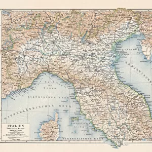
Canvas Print : Northern Italy map


![]()
Canvas Prints from Fine Art Storehouse
Northern Italy map
A highly decorative and finely engraved map of Northern Italy which appeared in John Tallis & co.s The Illustrated Atlas 1851
Unleash your creativity and transform your space into a visual masterpiece!
BernardAllum
Media ID 18126235
© BernardAllum
20"x16" (50x40cm) Canvas Print
Add an elegant touch to your home decor with our Canvas Print of Northern Italy by Bernard Allum from the Media Storehouse Fine Art collection. This exquisite map, originally published in John Tallis & Co.'s The Illustrated Atlas in 1851, showcases intricate engravings of Northern Italy's historical regions and borders. The high-quality canvas print brings a sense of timeless charm and sophistication to any room. Explore the rich history of Italy through this beautifully detailed and decorative map.
Ready to hang Premium Gloss Canvas Print. Our archival quality canvas prints are made from Polyester and Cotton mix and stretched over a 1.25" (32mm) kiln dried knot free wood stretcher bar. Packaged in a plastic bag and secured to a cardboard insert for transit.
Canvas Prints add colour, depth and texture to any space. Professionally Stretched Canvas over a hidden Wooden Box Frame and Ready to Hang
Estimated Product Size is 50.8cm x 40.6cm (20" x 16")
These are individually made so all sizes are approximate
Artwork printed orientated as per the preview above, with landscape (horizontal) orientation to match the source image.
FEATURES IN THESE COLLECTIONS
> Arts
> Artists
> T
> John Tallis
> Europe
> Italy
> Related Images
> Maps and Charts
> Italy
> Maps and Charts
> Related Images
> Maps and Charts
> World
> Fine Art Storehouse
> Map
> Historical Maps
> Fine Art Storehouse
> Map
> Italian Maps
EDITORS COMMENTS
This stunning print showcases a highly decorative and finely engraved map of Northern Italy, taken from John Tallis & Co. 's renowned The Illustrated Atlas in 1851. Crafted with meticulous attention to detail, this cartographic masterpiece is a testament to the artistry and precision of engraving techniques during that era. The ornate design of the map captivates viewers with its intricate borders and elegant embellishments. Every city, town, river, and mountain range is meticulously depicted, allowing us to explore the enchanting landscape of Northern Italy from centuries ago. This historical artifact not only serves as a navigational tool but also as a work of art that reflects the grandeur and sophistication of cartography in the 19th century. Presented in a horizontal format, this print invites us on an immersive journey through time. Its rich colors bring life to every corner of the map while highlighting key landmarks such as Venice's canals or Milan's majestic cathedral. Whether you are an avid traveler or simply appreciate fine craftsmanship, this print will undoubtedly add elegance and charm to any space it graces. Bernard Allum has skillfully captured the essence of this remarkable piece with his expert photography skills. Through his lens, we are able to admire every intricate line and delicate detail preserved within this historical treasure. Displaying Bernard Allum's passion for capturing beauty through imagery, this photograph truly pays homage to both history and artistry alike.
MADE IN THE UK
Safe Shipping with 30 Day Money Back Guarantee
FREE PERSONALISATION*
We are proud to offer a range of customisation features including Personalised Captions, Color Filters and Picture Zoom Tools
SECURE PAYMENTS
We happily accept a wide range of payment options so you can pay for the things you need in the way that is most convenient for you
* Options may vary by product and licensing agreement. Zoomed Pictures can be adjusted in the Basket.