
Canvas Print > Fine Art Storehouse > Map
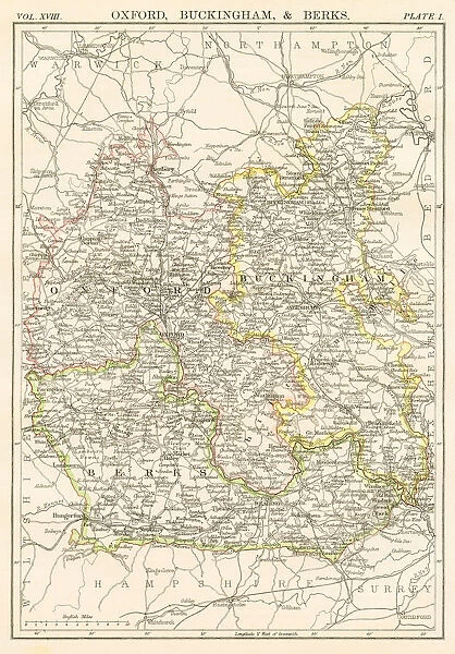
Canvas Print : Oxford and Buckingham map 1885


![]()
Canvas Prints from Fine Art Storehouse
Oxford and Buckingham map 1885
Encyclopedia Britannica 9th Edition New York Charles Scribners and Sons 1885 Vol XVIII
Unleash your creativity and transform your space into a visual masterpiece!
THEPALMER
Media ID 14549427
© This content is subject to copyright
20"x16" (50x40cm) Canvas Print
Step back in time with our exquisite Canvas Print of the Oxford and Buckingham Map from THEPALMER, published in the Encyclopedia Britannica 9th Edition in 1885. This stunning vintage map, sourced from the Fine Art Storehouse, showcases intricate details of the Oxfordshire and Buckinghamshire regions during the late 19th century. The high-quality canvas print brings history to life, with its rich colors and textures, making it a perfect addition to any home or office space. Transport yourself to a bygone era with this beautiful and unique piece of art.
Ready to hang Premium Gloss Canvas Print. Our archival quality canvas prints are made from Polyester and Cotton mix and stretched over a 1.25" (32mm) kiln dried knot free wood stretcher bar. Packaged in a plastic bag and secured to a cardboard insert for transit.
Canvas Prints add colour, depth and texture to any space. Professionally Stretched Canvas over a hidden Wooden Box Frame and Ready to Hang
Estimated Product Size is 40.6cm x 50.8cm (16" x 20")
These are individually made so all sizes are approximate
Artwork printed orientated as per the preview above, with portrait (vertical) orientation to match the source image.
FEATURES IN THESE COLLECTIONS
> Fine Art Storehouse
> Map
> Historical Maps
EDITORS COMMENTS
This print titled "Oxford and Buckingham map 1885" takes us back in time to the late 19th century, offering a glimpse into the rich history and intricate details of these iconic British locations. The image is sourced from the Encyclopedia Britannica's 9th Edition, published by Charles Scribners and Sons in New York in 1885. The map showcases an exquisite level of craftsmanship, meticulously depicting the cities of Oxford and Buckingham along with their surrounding areas. Every street, building, park, and river is intricately illustrated, inviting us to explore this bygone era through cartographic artistry. As we delve into this historical masterpiece captured by THEPALMER for Fine Art Storehouse, we are transported to a time when horse-drawn carriages roamed these streets and grand architecture adorned every corner. The attention to detail allows us to appreciate not only the layout of these cities but also their cultural significance during that period. Whether you have a personal connection to Oxford or Buckingham or simply admire European history at large, this print serves as a window into our past. It sparks curiosity about how life might have been in these bustling towns over a century ago. Displaying this artwork on your wall will undoubtedly evoke conversations about heritage, architecture, and nostalgia among friends and family alike. Let it transport you back in time as you immerse yourself in the beauty of Oxford and Buckingham's yesteryears through this remarkable visual representation.
MADE IN THE UK
Safe Shipping with 30 Day Money Back Guarantee
FREE PERSONALISATION*
We are proud to offer a range of customisation features including Personalised Captions, Color Filters and Picture Zoom Tools
SECURE PAYMENTS
We happily accept a wide range of payment options so you can pay for the things you need in the way that is most convenient for you
* Options may vary by product and licensing agreement. Zoomed Pictures can be adjusted in the Basket.


