Canvas Print > Africa > Togo > Maps
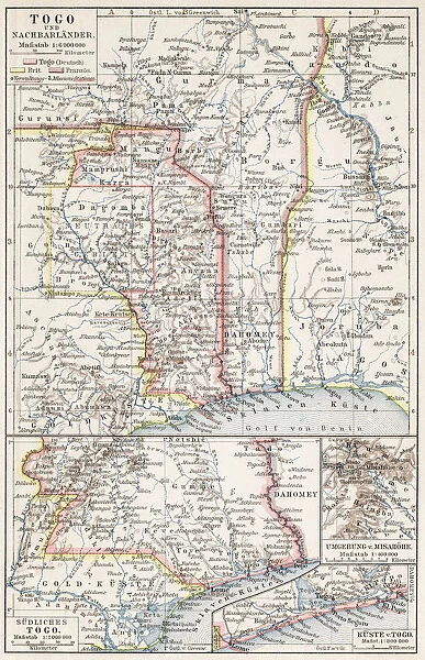
Canvas Print : Map of Togo 1900
![]()

Canvas Prints from Fine Art Storehouse
Map of Togo 1900
Meyers hand-Atlas Leipzig und Wien Verlag des Bibliographischen Instituts 1900
Unleash your creativity and transform your space into a visual masterpiece!
THEPALMER
Media ID 18106915
© 2014 Roberto Adrian Photography
21"x14" (53x35cm) Canvas Print
Step back in time with our exquisite Canvas Print of the Map of Togo 1900 from THEPALMER's collection at Media Storehouse. This fine art piece is taken from the renowned Meyers Hand-Atlas Leipzig und Wien Verlag des Bibliographischen Instituts 1900. The intricate details and vibrant colors of this historical map are beautifully rendered on high-quality canvas, adding an elegant and distinctive touch to any room. Transport yourself to a bygone era with this captivating and conversation-starting addition to your decor.
Ready to hang Premium Gloss Canvas Print. Our archival quality canvas prints are made from Polyester and Cotton mix and stretched over a 1.25" (32mm) kiln dried knot free wood stretcher bar. Packaged in a plastic bag and secured to a cardboard insert for transit.
Canvas Prints add colour, depth and texture to any space. Professionally Stretched Canvas over a hidden Wooden Box Frame and Ready to Hang
Estimated Product Size is 35.6cm x 53.3cm (14" x 21")
These are individually made so all sizes are approximate
Artwork printed orientated as per the preview above, with portrait (vertical) orientation to match the source image.
FEATURES IN THESE COLLECTIONS
> Africa
> Togo
> Related Images
> Fine Art Storehouse
> Map
> Historical Maps
EDITORS COMMENTS
This print showcases a rare gem from the past - the "Map of Togo 1900". With its origins dating back over a century, this historical artifact offers us a glimpse into the world as it was in that era. The map, originally published in Leipzig und Wien by Verlag des Bibliographischen Instituts in 1900, is an exquisite example of cartographic artistry. The intricate details and meticulous craftsmanship evident on this map are truly remarkable. Every contour and boundary line has been delicately etched onto the paper, revealing Togo's geographical features with utmost precision. As we gaze upon this vintage masterpiece, we can't help but marvel at how far cartography has come since then. Beyond its aesthetic appeal, this print serves as a time capsule connecting us to an era long gone. It sparks curiosity about what life was like in Togo during those times - the bustling cities, remote villages nestled amidst lush landscapes, and untrodden paths waiting to be explored. "The Map of Togo 1900" transports us back to an age when maps were cherished possessions that guided adventurers and explorers through uncharted territories. It reminds us of our innate human desire for discovery and understanding of our surroundings. Thanks to THEPALMER's skillful preservation work and Fine Art Storehouse's dedication to sharing these treasures with art enthusiasts worldwide, we have the privilege of owning or admiring this extraordinary piece today. Let it inspire you to embark on your own journey of exploration -
MADE IN THE UK
Safe Shipping with 30 Day Money Back Guarantee
FREE PERSONALISATION*
We are proud to offer a range of customisation features including Personalised Captions, Color Filters and Picture Zoom Tools
SECURE PAYMENTS
We happily accept a wide range of payment options so you can pay for the things you need in the way that is most convenient for you
* Options may vary by product and licensing agreement. Zoomed Pictures can be adjusted in the Basket.


