Canvas Print > Europe > France > Paris > Maps
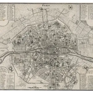
Canvas Print : Map of Paris 1900


![]()
Canvas Prints from Fine Art Storehouse
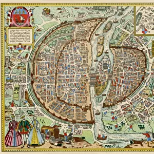
Map of Paris 1900
Meyers hand-Atlas Leipzig und Wien Verlag des Bibliographischen Instituts 1900
Unleash your creativity and transform your space into a visual masterpiece!
THEPALMER
Media ID 18106901
© 2014 Roberto Adrian Photography
20"x16" (50x40cm) Canvas Print
Introducing the exquisite "Map of Paris 1900" Canvas Print from Media Storehouse's Fine Art Storehouse collection. This captivating piece, brought to you by THEPALMER, is taken from the esteemed Meyers Hand-Atlas published by Leipzig und Wien Verlag des Bibliographischen Instituts in 1900. Transport yourself back in time as you explore the intricate details of Parisian streets and landmarks, meticulously captured in this beautifully preserved map. Add a touch of history and elegance to your home or office with this stunning, museum-quality Canvas Print. Let the story of Paris unfold on your walls.
Ready to hang Premium Gloss Canvas Print. Our archival quality canvas prints are made from Polyester and Cotton mix and stretched over a 1.25" (32mm) kiln dried knot free wood stretcher bar. Packaged in a plastic bag and secured to a cardboard insert for transit.
Canvas Prints add colour, depth and texture to any space. Professionally Stretched Canvas over a hidden Wooden Box Frame and Ready to Hang
Estimated Product Size is 50.8cm x 40.6cm (20" x 16")
These are individually made so all sizes are approximate
Artwork printed orientated as per the preview above, with landscape (horizontal) orientation to match the source image.
FEATURES IN THESE COLLECTIONS
> Europe
> France
> Paris
> Maps
> Fine Art Storehouse
> Map
> Historical Maps
EDITORS COMMENTS
In this print titled "Map of Paris 1900" we are transported back in time to the enchanting streets of the French capital at the turn of the century. The meticulous detail and intricate design showcased in this piece, sourced from Meyers hand-Atlas Leipzig und Wien Verlag des Bibliographischen Instituts in 1900, truly captures the essence of a bygone era. As we gaze upon this vintage map, our eyes are immediately drawn to its rich colors and delicate lines that depict every street, boulevard, and landmark with remarkable precision. It is as if we can almost hear the bustling sounds of horse-drawn carriages echoing through these historic avenues. The artist behind this extraordinary creation, known simply as THEPALMER, has masterfully preserved not only a geographical representation but also an artistic testament to Parisian culture during that period. From iconic landmarks like Notre-Dame Cathedral and the Eiffel Tower to lesser-known neighborhoods brimming with charm and character, each corner tells a story waiting to be discovered. This print serves as both a visual delight for admirers of cartography and history enthusiasts alike. Whether displayed on your wall or carefully studied up close, it invites us on an imaginary journey through time – allowing us to immerse ourselves in early 20th-century Parisian life while igniting our curiosity about how much has changed since then. "The Map of Paris 1900" by THEPALMER is more than just a decorative piece; it's an
MADE IN THE UK
Safe Shipping with 30 Day Money Back Guarantee
FREE PERSONALISATION*
We are proud to offer a range of customisation features including Personalised Captions, Color Filters and Picture Zoom Tools
SECURE PAYMENTS
We happily accept a wide range of payment options so you can pay for the things you need in the way that is most convenient for you
* Options may vary by product and licensing agreement. Zoomed Pictures can be adjusted in the Basket.