Canvas Print > Maps and Charts > Turkey
Canvas Print : Map of european Turkey 1900


![]()
Canvas Prints from Fine Art Storehouse
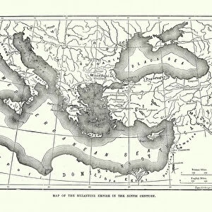
Map of european Turkey 1900
Meyers hand-Atlas Leipzig und Wien Verlag des Bibliographischen Instituts 1900
Unleash your creativity and transform your space into a visual masterpiece!
THEPALMER
Media ID 18106905
© 2014 Roberto Adrian Photography
20"x16" (50x40cm) Canvas Print
Discover the rich history of Europe's past with our exquisite Canvas Print of the Map of European Turkey from THEPALMER's collection at Media Storehouse. This stunning piece, taken from the Meyers Hand-Atlas published by the Bibliographisches Institut in Leipzig and Wien in 1900, showcases the political landscape of Europe during that era. The intricate details of the map are brought to life with our premium canvas printing technology, creating a beautiful and captivating piece for your home or office. Travel back in time and add a touch of history to your space with this unique and authentic work of art.
Ready to hang Premium Gloss Canvas Print. Our archival quality canvas prints are made from Polyester and Cotton mix and stretched over a 1.25" (32mm) kiln dried knot free wood stretcher bar. Packaged in a plastic bag and secured to a cardboard insert for transit.
Canvas Prints add colour, depth and texture to any space. Professionally Stretched Canvas over a hidden Wooden Box Frame and Ready to Hang
Estimated Product Size is 50.8cm x 40.6cm (20" x 16")
These are individually made so all sizes are approximate
Artwork printed orientated as per the preview above, with landscape (horizontal) orientation to match the source image.
FEATURES IN THESE COLLECTIONS
> Asia
> Turkey
> Related Images
> Europe
> Related Images
> Fine Art Storehouse
> Map
> Historical Maps
EDITORS COMMENTS
This print showcases a historical gem, the "Map of European Turkey 1900" sourced from the renowned Meyers Hand-Atlas Leipzig und Wien Verlag des Bibliographischen Instituts in 1900. With its intricate details and exquisite craftsmanship, this piece takes us on a journey back in time to explore the geopolitical landscape of Europe during that era. The map itself is a testament to the artistry and precision involved in cartography. Every contour, border, and label has been meticulously etched onto paper with utmost care. It offers an intriguing glimpse into how boundaries were defined and territories were divided at the turn of the century. As we examine this vintage masterpiece, we are transported to an era when empires rose and fell, shaping history as we know it today. The delicate colors used to differentiate countries evoke a sense of nostalgia for bygone times. Each region tells its own story - from bustling cities to remote villages nestled amidst breathtaking landscapes. "The Map of European Turkey 1900" invites us to reflect upon our shared heritage while marveling at how much our world has evolved over time. It serves as a reminder that history is not merely confined within textbooks; it lives on through artifacts like this remarkable map print. Whether you're an avid historian or simply appreciate fine art, this print will undoubtedly captivate your imagination and spark conversations about Europe's rich past. Let it adorn your walls as both a stunning decorative piece and a window into another era – one that continues to shape our
MADE IN THE UK
Safe Shipping with 30 Day Money Back Guarantee
FREE PERSONALISATION*
We are proud to offer a range of customisation features including Personalised Captions, Color Filters and Picture Zoom Tools
SECURE PAYMENTS
We happily accept a wide range of payment options so you can pay for the things you need in the way that is most convenient for you
* Options may vary by product and licensing agreement. Zoomed Pictures can be adjusted in the Basket.