Canvas Print > Europe > Hungary > Maps
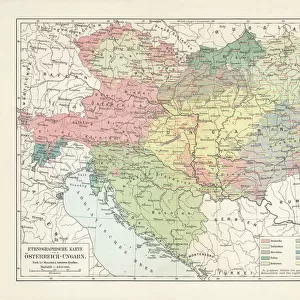
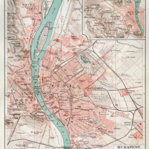
Canvas Print : Geological map of the Austro-Hungarian Empire, lithograph, published in 1897


![]()
Canvas Prints from Fine Art Storehouse
Geological map of the Austro-Hungarian Empire, lithograph, published in 1897
Geological map of the Austro-Hungarian Empire. Lithograph, published in 1897
Unleash your creativity and transform your space into a visual masterpiece!
ZU_09
Media ID 18292217
20"x16" (50x40cm) Canvas Print
Discover the rich history and geological wonders of the Austro-Hungarian Empire with our stunning Canvas Print of the 1897 Geological Map. This intricately detailed lithograph, published by ZU_09 from Fine Art Storehouse, showcases the complex geological formations and boundaries of the Austro-Hungarian Empire during that time. Bring this captivating piece of historical cartography into your home or office to inspire curiosity and ignite conversations. Each Canvas Print is carefully crafted using premium materials and vibrant colors, ensuring a beautiful and long-lasting addition to your space.
Ready to hang Premium Gloss Canvas Print. Our archival quality canvas prints are made from Polyester and Cotton mix and stretched over a 1.25" (32mm) kiln dried knot free wood stretcher bar. Packaged in a plastic bag and secured to a cardboard insert for transit.
Canvas Prints add colour, depth and texture to any space. Professionally Stretched Canvas over a hidden Wooden Box Frame and Ready to Hang
Estimated Product Size is 50.8cm x 40.6cm (20" x 16")
These are individually made so all sizes are approximate
Artwork printed orientated as per the preview above, with landscape (horizontal) orientation to match the source image.
FEATURES IN THESE COLLECTIONS
> Europe
> Hungary
> Related Images
> Maps and Charts
> Geological Map
> Maps and Charts
> Related Images
> Fine Art Storehouse
> Map
> Historical Maps
EDITORS COMMENTS
This lithograph, titled "Geological map of the Austro-Hungarian Empire" takes us on a journey back in time to the late 19th century. Published in 1897, this intricate print offers a visual representation of the geological landscape that once defined this vast empire. Created by ZU_09, an artist whose attention to detail is evident in every stroke and contour, this piece showcases both scientific accuracy and artistic finesse. As we delve into the depths of this lithograph, we are transported across borders and through diverse terrains. The map reveals a tapestry of colors and patterns that symbolize various rock formations, mineral deposits, and geographical features unique to each region within the Austro-Hungarian Empire. From towering mountain ranges to meandering rivers and fertile plains, every inch of land is meticulously documented with precision. Beyond its scientific value lies an aesthetic appeal that captivates our imagination. The delicate lines crisscrossing the paper create an intricate web connecting different parts of this vast empire. Each stroke seems purposeful yet graceful as it guides our eyes from one area to another. This lithograph serves as a testament to not only the geological richness but also the historical significance of the Austro-Hungarian Empire during its zenith. It reminds us that beneath our feet lie stories untold – tales carved by nature's forces over millennia. Whether you are a geology enthusiast or simply appreciate fine artistry, this print invites you to explore history through a lens
MADE IN THE UK
Safe Shipping with 30 Day Money Back Guarantee
FREE PERSONALISATION*
We are proud to offer a range of customisation features including Personalised Captions, Color Filters and Picture Zoom Tools
SECURE PAYMENTS
We happily accept a wide range of payment options so you can pay for the things you need in the way that is most convenient for you
* Options may vary by product and licensing agreement. Zoomed Pictures can be adjusted in the Basket.