Canvas Print > Oceania > Australia > Maps
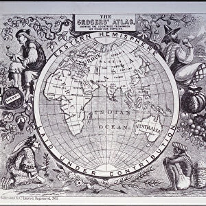
Canvas Print : Antique map of old world depicting voyages of Captain Cook


![]()
Canvas Prints from Fine Art Storehouse
Antique map of old world depicting voyages of Captain Cook
africa, antique, archival, asia, australia, border, captain cook, carto, Antique Maps, 87719936
Unleash your creativity and transform your space into a visual masterpiece!
Hemera Technologies
Media ID 18843847
© Getty Images
20"x16" (50x40cm) Canvas Print
Step back in time with our stunning Antique Map Canvas Print from the Media Storehouse collection at Fine Art Storehouse. This captivating representation of the Old World, featuring the voyages of Captain Cook, is brought to life by Hemera Technologies. Meticulously crafted from an antique map, this archival-quality print showcases intricate details of the continents of Africa, Asia, and Australia, with borders that tell stories of exploration and discovery. Add a touch of history and timeless elegance to your home or office decor with this beautiful and authentic work of art.
Ready to hang Premium Gloss Canvas Print. Our archival quality canvas prints are made from Polyester and Cotton mix and stretched over a 1.25" (32mm) kiln dried knot free wood stretcher bar. Packaged in a plastic bag and secured to a cardboard insert for transit.
Canvas Prints add colour, depth and texture to any space. Professionally Stretched Canvas over a hidden Wooden Box Frame and Ready to Hang
Estimated Product Size is 50.8cm x 40.6cm (20" x 16")
These are individually made so all sizes are approximate
Artwork printed orientated as per the preview above, with landscape (horizontal) orientation to match the source image.
FEATURES IN THESE COLLECTIONS
> Africa
> Related Images
> Asia
> Related Images
> Maps and Charts
> Related Images
> Maps and Charts
> World
> Oceania
> Australia
> Related Images
> Fine Art Storehouse
> Map
> Historical Maps
EDITORS COMMENTS
This print takes us on a journey back in time, immersing us in the fascinating world of exploration and discovery. The antique map displayed here showcases the voyages of Captain Cook, an iconic figure who fearlessly ventured into uncharted territories during the 18th century. With its intricate details and delicate borders, this archival piece offers a glimpse into the old world as seen through the eyes of early cartographers. Africa, Asia, Australia - all these continents are beautifully depicted on this vintage map, revealing the vastness and diversity of our planet. Each line drawn with precision tells a story of adventure and curiosity that once drove explorers like Captain Cook to embark on perilous expeditions across unknown seas. The rich colors and aged texture evoke a sense of nostalgia for bygone eras when maps were treasured possessions guiding intrepid travelers towards new horizons. This print from Hemera Technologies captures not only historical accuracy but also artistic beauty that will surely enhance any space it graces. Whether you're an avid collector or simply appreciate art with historical significance, this antique map is sure to captivate your imagination. Let it transport you to distant lands where brave souls like Captain Cook sailed in search of knowledge and wonderment. Embrace the allure of exploration as you admire this exquisite piece from Fine Art Storehouse's collection – a true testament to human curiosity and our endless quest for understanding our world's past.
MADE IN THE UK
Safe Shipping with 30 Day Money Back Guarantee
FREE PERSONALISATION*
We are proud to offer a range of customisation features including Personalised Captions, Color Filters and Picture Zoom Tools
SECURE PAYMENTS
We happily accept a wide range of payment options so you can pay for the things you need in the way that is most convenient for you
* Options may vary by product and licensing agreement. Zoomed Pictures can be adjusted in the Basket.