Canvas Print > Africa > Egypt > Maps
Canvas Print : Antique map of Lower Egypt


![]()
Canvas Prints from Fine Art Storehouse
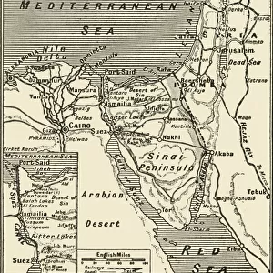
Antique map of Lower Egypt
Vintage map from 1861 of Lower Egypt showing the journeys of the Israelites
Unleash your creativity and transform your space into a visual masterpiece!
duncan1890
Media ID 18062783
© duncan1890
20"x16" (50x40cm) Canvas Print
Step back in time with our exquisite Canvas Print of an Antique Map of Lower Egypt by duncan1890 from the Media Storehouse Fine Art collection. This vintage map, dating back to 1861, beautifully illustrates the journeys of the Israelites. Each detail is meticulously rendered, transporting you to a bygone era. The high-quality canvas print brings the rich history of this ancient land to life in your home, making it a unique and captivating addition to any room. Experience the charm of the past with this beautiful work of art.
Ready to hang Premium Gloss Canvas Print. Our archival quality canvas prints are made from Polyester and Cotton mix and stretched over a 1.25" (32mm) kiln dried knot free wood stretcher bar. Packaged in a plastic bag and secured to a cardboard insert for transit.
Canvas Prints add colour, depth and texture to any space. Professionally Stretched Canvas over a hidden Wooden Box Frame and Ready to Hang
Estimated Product Size is 50.8cm x 40.6cm (20" x 16")
These are individually made so all sizes are approximate
Artwork printed orientated as per the preview above, with landscape (horizontal) orientation to match the source image.
FEATURES IN THESE COLLECTIONS
> Africa
> Egypt
> Related Images
> Historic
> Ancient civilizations
> Ancient Egypt
> Historic
> Ancient civilizations
> Maps and Charts
> Early Maps
> Maps and Charts
> Related Images
> Fine Art Storehouse
> Map
> Historical Maps
EDITORS COMMENTS
This print takes us on a journey back in time to the ancient land of Lower Egypt. Displayed before our eyes is an exquisite vintage map, meticulously crafted in 1861 by an unknown cartographer. This remarkable piece showcases the intricate journeys undertaken by the Israelites during their historic sojourn through this region. The map itself is a testament to both artistry and historical significance. Its delicate details and faded hues transport us to a time when cartography was not only a scientific pursuit but also an artistic expression. As we gaze upon its carefully drawn borders, rivers, and cities, we are reminded of the rich tapestry of civilizations that once flourished across these lands. Lower Egypt's role as a cradle of ancient civilization becomes evident as we study this antique map further. It whispers tales of pharaohs reigning over mighty kingdoms, bustling trade routes connecting distant lands, and cultural exchanges shaping human history. Duncan1890's expertly captured photograph allows us to appreciate every nuance and intricacy present within this historical artifact. The fine details preserved in this print awaken our curiosity about past eras while serving as a reminder that even centuries-old maps can still hold relevance today. Whether you are fascinated by Middle Eastern history or simply captivated by the beauty of antique maps, this stunning print will undoubtedly add depth and intrigue to any space it graces.
MADE IN THE UK
Safe Shipping with 30 Day Money Back Guarantee
FREE PERSONALISATION*
We are proud to offer a range of customisation features including Personalised Captions, Color Filters and Picture Zoom Tools
SECURE PAYMENTS
We happily accept a wide range of payment options so you can pay for the things you need in the way that is most convenient for you
* Options may vary by product and licensing agreement. Zoomed Pictures can be adjusted in the Basket.