Canvas Print > Europe > United Kingdom > England > Cambridge
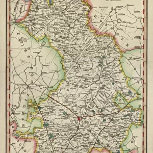
Canvas Print : Huntingdon and Cambridge map 1881


![]()
Canvas Prints from Fine Art Storehouse
Huntingdon and Cambridge map 1881
Encyclopedia Britannica 9th Edition Vol XII Philadelphia j.M. Stoddart & Co 1881
Unleash your creativity and transform your space into a visual masterpiece!
THEPALMER
Media ID 13611525
© This content is subject to copyright
Cambridge England Paper World Map Huntingdon
20"x16" (50x40cm) Canvas Print
Introducing the exquisite "Huntingdon and Cambridge Map 1881" Canvas Print from Media Storehouse's Fine Art Storehouse collection. This stunning piece of art is an accurate reproduction of the original map published in the Encyclopedia Britannica 9th Edition, Volume XII, by J.M. Stoddart & Co in Philadelphia, 1881. The map showcases the intricate details of Huntingdon and Cambridge during this historical period, making it an essential addition to any home or office decor. The high-quality canvas print brings the rich history of the region to life, with vibrant colors and sharp details that truly capture the essence of the original. Hang it up and let this beautiful piece transport you back in time.
Ready to hang Premium Gloss Canvas Print. Our archival quality canvas prints are made from Polyester and Cotton mix and stretched over a 1.25" (32mm) kiln dried knot free wood stretcher bar. Packaged in a plastic bag and secured to a cardboard insert for transit.
Canvas Prints add colour, depth and texture to any space. Professionally Stretched Canvas over a hidden Wooden Box Frame and Ready to Hang
Estimated Product Size is 40.6cm x 50.8cm (16" x 20")
These are individually made so all sizes are approximate
Artwork printed orientated as per the preview above, with portrait (vertical) orientation to match the source image.
FEATURES IN THESE COLLECTIONS
> Europe
> United Kingdom
> England
> Cambridge
> Europe
> United Kingdom
> England
> Maps
> Europe
> United Kingdom
> England
> Posters
> Europe
> United Kingdom
> England
> Related Images
> Maps and Charts
> Related Images
> Maps and Charts
> World
> North America
> United States of America
> Maps
> Fine Art Storehouse
> The Magical World of Illustration
> Palmer Illustrated Collection
> Fine Art Storehouse
> Map
> Historical Maps
> Fine Art Storehouse
> Map
> USA Maps
EDITORS COMMENTS
This print takes us back in time to the year 1881, when cartography was a meticulous art form. The image showcases a beautifully detailed map titled "Huntingdon and Cambridge" extracted from the Encyclopedia Britannica's 9th Edition Volume XII. Crafted by J. M. Stoddart & Co in Philadelphia, this antique piece of paper holds immense historical value. The map itself is an exquisite example of engraving, displaying intricate lines and delicate illustrations that bring to life the physical geography of Huntingdon and Cambridge in England. As we gaze upon it, we are transported to a world where exploration was still unfolding, and maps were essential tools for understanding our surroundings. The choice to capture this particular section of the world on such an elaborate map speaks volumes about its significance during that era. It serves as a reminder of how cartographers painstakingly crafted these works of art with precision and dedication. "ThePALMER" has skillfully preserved this remarkable piece through photography, allowing us to appreciate its beauty even today. This vertical composition invites us to delve into history while admiring the fine details etched onto the aged paper. Whether you're an enthusiast fascinated by old-world charm or someone intrigued by geographical evolution, this print is sure to captivate your imagination and transport you back in time.
MADE IN THE UK
Safe Shipping with 30 Day Money Back Guarantee
FREE PERSONALISATION*
We are proud to offer a range of customisation features including Personalised Captions, Color Filters and Picture Zoom Tools
SECURE PAYMENTS
We happily accept a wide range of payment options so you can pay for the things you need in the way that is most convenient for you
* Options may vary by product and licensing agreement. Zoomed Pictures can be adjusted in the Basket.