Canvas Print > Fine Art Finder > Maps (celestial & Terrestrial)
Canvas Print : Map of Oxford, 1643 (engraving) (b / w photo)
 (b / w photo)")
 (b / w photo)")


![]()
Canvas Prints from Fine Art Finder
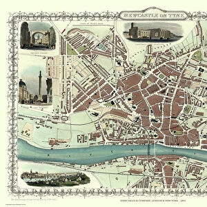
Map of Oxford, 1643 (engraving) (b / w photo)
XJF270067 Map of Oxford, 1643 (engraving) (b/w photo) by Hollar, Wenceslaus (1607-77); Private Collection; Czech, out of copyright
Media ID 12783161
© www.bridgemanart.com
Aerial View Colleges Compass Index
20"x16" (50x40cm) Canvas Print
Discover the rich history of Oxford with our stunning Canvas Prints from Media Storehouse. Featuring an exquisite engraving of a Map of Oxford from 1643 by the renowned artist Wenceslaus Hollar. This black and white photograph, sourced from Bridgeman Art Library, offers a captivating glimpse into the past, transporting you back in time to the 17th century. Add this beautiful work of art to your home or office to inspire a sense of history and culture. Each Canvas Print is expertly crafted with high-quality materials and vibrant colors, ensuring a long-lasting and eye-catching addition to your space.
Ready to hang Premium Gloss Canvas Print. Our archival quality canvas prints are made from Polyester and Cotton mix and stretched over a 1.25" (32mm) kiln dried knot free wood stretcher bar. Packaged in a plastic bag and secured to a cardboard insert for transit.
Canvas Prints add colour, depth and texture to any space. Professionally Stretched Canvas over a hidden Wooden Box Frame and Ready to Hang
Estimated Product Size is 50.8cm x 40.6cm (20" x 16")
These are individually made so all sizes are approximate
Artwork printed orientated as per the preview above, with landscape (horizontal) orientation to match the source image.
FEATURES IN THESE COLLECTIONS
> Fine Art Finder
> Artists
> Wenceslaus Hollar
> Fine Art Finder
> Maps (celestial & Terrestrial)
EDITORS COMMENTS
This print takes us back in time to the year 1643, showcasing a meticulously detailed engraving of the Map of Oxford. Created by Wenceslaus Hollar, a renowned Czech artist from the 17th century, this piece is now part of a private collection. The map offers an aerial view of Oxford, providing a fascinating glimpse into the city's layout during that era. With its intricate index and clearly marked streets, it serves as both a navigational tool and historical artifact. The presence of numerous colleges indicates Oxford's long-standing reputation as an esteemed center for education and learning. A compass elegantly adorns one corner of the map, reminding us of the importance placed on accurate direction in those times. Additionally, we can spot the coat of arms representing Oxford University - an emblem synonymous with knowledge and intellectual pursuit. As we delve into this mesmerizing artwork, let us appreciate not only its artistic value but also its ability to transport us back centuries ago. It allows us to envision how life may have unfolded within these historic walls while marveling at Hollar's skillful craftsmanship.
MADE IN THE UK
Safe Shipping with 30 Day Money Back Guarantee
FREE PERSONALISATION*
We are proud to offer a range of customisation features including Personalised Captions, Color Filters and Picture Zoom Tools
SECURE PAYMENTS
We happily accept a wide range of payment options so you can pay for the things you need in the way that is most convenient for you
* Options may vary by product and licensing agreement. Zoomed Pictures can be adjusted in the Basket.