Canvas Print > Europe > France > Maps
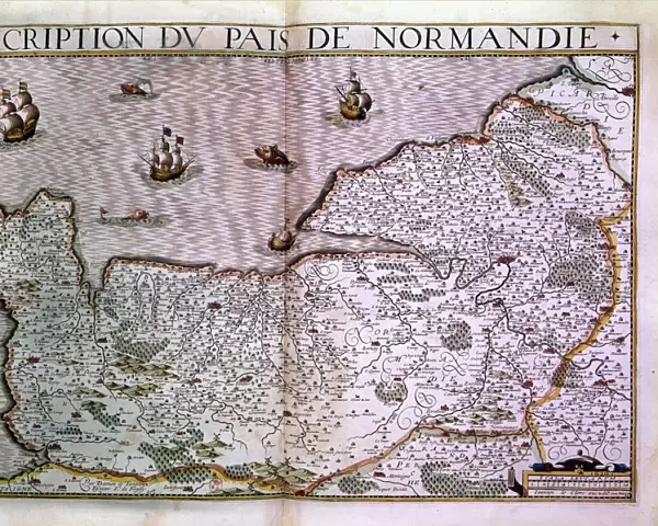
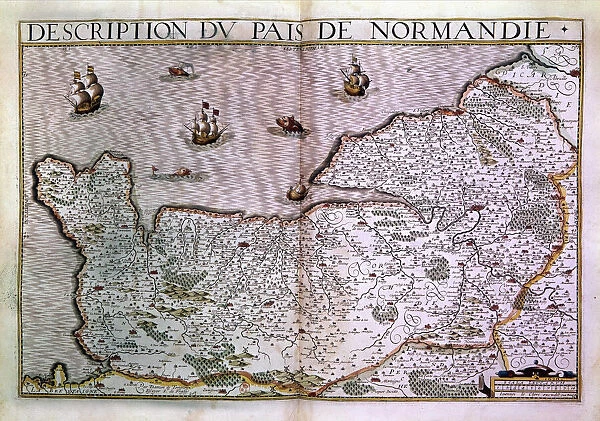
Canvas Print : Description of the Normandy pais. Map of the Normandy region in 1620


![]()
Canvas Prints from Fine Art Finder
Description of the Normandy pais. Map of the Normandy region in 1620
XEE4405463 Description of the Normandy pais. Map of the Normandy region in 1620. by Unknown Artist, (17th century); Private Collection; (add.info.: Description of the Normandy pais. Map of the Normandy region in 1620.); Stefano Bianchetti; out of copyright
Media ID 22482064
© Stefano Bianchetti / Bridgeman Images
20"x16" (50x40cm) Canvas Print
Discover the rich history of Normandy with our exquisite Canvas Prints from Media Storehouse. Featuring an intricately detailed map of the Normandy region from the 17th century, this vintage print by Unknown Artist (XEE4405463) transports you back in time. Meticulously reproduced from the original work by Stefano Bianchetti from Fine Art Finder, each print is carefully crafted on premium canvas to bring out the vibrant colors and textures of the map. Add a touch of history and elegance to your home decor with this beautiful and unique piece.
Ready to hang Premium Gloss Canvas Print. Our archival quality canvas prints are made from Polyester and Cotton mix and stretched over a 1.25" (32mm) kiln dried knot free wood stretcher bar. Packaged in a plastic bag and secured to a cardboard insert for transit.
Canvas Prints add colour, depth and texture to any space. Professionally Stretched Canvas over a hidden Wooden Box Frame and Ready to Hang
Estimated Product Size is 50.8cm x 40.6cm (20" x 16")
These are individually made so all sizes are approximate
Artwork printed orientated as per the preview above, with landscape (horizontal) orientation to match the source image.
FEATURES IN THESE COLLECTIONS
> Maps and Charts
> Related Images
> Fine Art Finder
> Artists
> Unknown Artist
EDITORS COMMENTS
This print showcases a historical gem - the "Description of the Normandy pais. Map of the Normandy region in 1620". Created by an unknown artist in the 17th century, this map offers a fascinating glimpse into the geography and knowledge of that time. The intricate details and precision of this map are truly remarkable. It provides a comprehensive overview of Normandy, a picturesque region located in northern France. From its rolling hills to its charming coastal towns, every aspect is meticulously depicted, allowing viewers to immerse themselves in the beauty and diversity of this French province. As we gaze upon this print, we can't help but appreciate Stefano Bianchetti's skillful capture that brings out every nuance and fine line from centuries ago. The colors have been preserved flawlessly, making it feel as if we are transported back to 1620 when this map was first created. For history enthusiasts or those with an interest in French geography, this print is an invaluable addition to any collection. Its timeless appeal transcends generations and serves as a reminder of our ever-evolving world. Displayed proudly within private collections around the globe, this piece continues to inspire awe and curiosity about both past eras and present-day landscapes. Let us cherish these glimpses into history through artistry like A© Stefano Bianchetti's incredible photograph capturing such significant cultural artifacts for all to enjoy.
MADE IN THE UK
Safe Shipping with 30 Day Money Back Guarantee
FREE PERSONALISATION*
We are proud to offer a range of customisation features including Personalised Captions, Color Filters and Picture Zoom Tools
SECURE PAYMENTS
We happily accept a wide range of payment options so you can pay for the things you need in the way that is most convenient for you
* Options may vary by product and licensing agreement. Zoomed Pictures can be adjusted in the Basket.