Canvas Print > Europe > United Kingdom > England > London > Politics > Arthur Wellesley
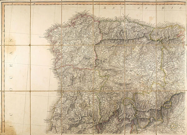
Canvas Print : Map of Spain said to have been used by the Duke of Wellington


![]()
Canvas Prints from Fine Art Finder
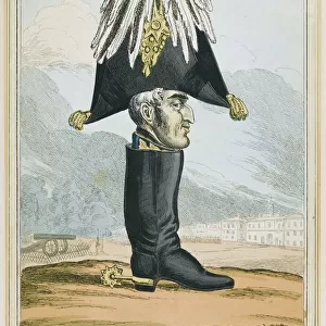
Map of Spain said to have been used by the Duke of Wellington
1772183 Map of Spain said to have been used by the Duke of Wellington, 1808-14 (coloured engraving) by English School, (19th century); National Army Museum, London; (add.info.: Arthur Wellesley (1 May 1769 - 14 September 1852) rose to prominence as a general during the Peninsular campaign. He was made Duke of Wellington in 1814 and finally defeated Napoleon at Waterloo the following year.); eNational Army Museum; English, out of copyright
Media ID 23537878
© National Army Museum / Bridgeman Images
Arthur Wellesley Atlantic Ocean Duke Of Wellington Iberia Iberian Peninsula Napoleonic Wars Peninsula Campaign Peninsula War Strategy
20"x16" (50x40cm) Canvas Print
Step back in time with our exquisite Canvas Print of a historic Map of Spain, believed to have been used by the Duke of Wellington during his campaigns in the early 19th century. This captivating engraving, sourced from Bridgeman Images and the National Army Museum, adds a touch of history and sophistication to any room. With its rich colors and intricate details, this fine art print is not just a decorative piece, but a window into the past. Bring the legacy of the Duke of Wellington into your home and transport yourself to another era with this stunning Canvas Print from Media Storehouse.
Ready to hang Premium Gloss Canvas Print. Our archival quality canvas prints are made from Polyester and Cotton mix and stretched over a 1.25" (32mm) kiln dried knot free wood stretcher bar. Packaged in a plastic bag and secured to a cardboard insert for transit.
Canvas Prints add colour, depth and texture to any space. Professionally Stretched Canvas over a hidden Wooden Box Frame and Ready to Hang
Estimated Product Size is 50.8cm x 40.6cm (20" x 16")
These are individually made so all sizes are approximate
Artwork printed orientated as per the preview above, with landscape (horizontal) orientation to match the source image.
FEATURES IN THESE COLLECTIONS
> Arts
> Artists
> O
> Oceanic Oceanic
> Arts
> Artists
> S
> Spanish School
> Europe
> Spain
> Related Images
> Europe
> United Kingdom
> England
> London
> Museums
> National Army Museum
> Europe
> United Kingdom
> England
> London
> Politics
> Arthur Wellesley
> Europe
> United Kingdom
> England
> London
> Towns
> Waterloo
> Maps and Charts
> Related Images
> Maps and Charts
> Spain
> Fine Art Finder
> Artists
> English School
> Fine Art Finder
> Artists
> Louis Charles Bombled
> Fine Art Finder
> Maps (celestial & Terrestrial)
EDITORS COMMENTS
This print showcases a historically significant "Map of Spain said to have been used by the Duke of Wellington". Created during the early 19th century, this coloured engraving offers a glimpse into the strategic mind of Arthur Wellesley, later known as the Duke of Wellington. Wellesley's rise to prominence occurred during the Peninsular campaign, where he demonstrated exceptional military prowess. This map served as an invaluable tool for him between 1808 and 1814 when leading British forces in Spain against Napoleon's army. Its detailed depiction of Spain and its surrounding regions provided crucial insights into terrain, fortifications, and potential routes for tactical maneuvers. The significance of this map is further amplified by Wellesley's subsequent achievements. In recognition of his remarkable leadership skills and victories over Napoleon's forces, he was bestowed with the title Duke of Wellington in 1814. The following year marked his ultimate triumph at Waterloo, solidifying his place in history as one of Europe's greatest military commanders. As we gaze upon this antique engraving held within London's National Army Museum collection, we are transported back to a time when maps were not merely decorative pieces but vital instruments guiding armies through treacherous landscapes. It serves as a testament to Wellesley's astute planning and unwavering determination throughout the Peninsula War. This image allows us to appreciate both its artistic qualities as an intricate piece of cartography and its historical significance within the context of Napoleonic Wars' European theater.
MADE IN THE UK
Safe Shipping with 30 Day Money Back Guarantee
FREE PERSONALISATION*
We are proud to offer a range of customisation features including Personalised Captions, Color Filters and Picture Zoom Tools
SECURE PAYMENTS
We happily accept a wide range of payment options so you can pay for the things you need in the way that is most convenient for you
* Options may vary by product and licensing agreement. Zoomed Pictures can be adjusted in the Basket.