Canvas Print > Europe > United Kingdom > England > Maps
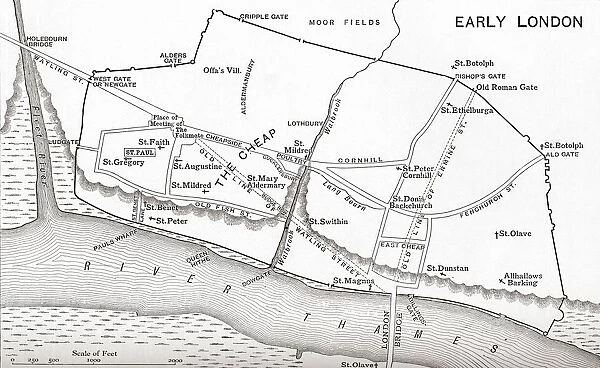
Canvas Print : Map Of London In The 11Th Century. From The Book Short History Of The English People By J. R. Green, Published London 1893
![]()

Canvas Prints from Design Pics
Map Of London In The 11Th Century. From The Book Short History Of The English People By J. R. Green, Published London 1893
Map Of London In The 11Th Century. From The Book Short History Of The English People By J.R. Green, Published London 1893
Design Pics offers Distinctively Different Imagery representing over 1,500 contributors
Media ID 18192329
© Ken Welsh / Design Pics
11th Ages Early Eleventh London Mediaeval Medieval Middle
21"x14" (53x35cm) Canvas Print
Step back in time with our stunning Canvas Print of a Map of London from the 11th Century, taken from J.R. Green's "Short History of the English People" published in London, 1893. This captivating historical map, brought to life by artist Ken Welsh, offers a unique glimpse into London's rich past. The intricate details and vibrant colors of this Canvas Print make it an exquisite addition to any room, transporting you to a bygone era. Perfect for history enthusiasts, this museum-quality Canvas Print is not just a piece of art, but a window into London's fascinating history.
Ready to hang Premium Gloss Canvas Print. Our archival quality canvas prints are made from Polyester and Cotton mix and stretched over a 1.25" (32mm) kiln dried knot free wood stretcher bar. Packaged in a plastic bag and secured to a cardboard insert for transit.
Canvas Prints add colour, depth and texture to any space. Professionally Stretched Canvas over a hidden Wooden Box Frame and Ready to Hang
Estimated Product Size is 53.3cm x 35.6cm (21" x 14")
These are individually made so all sizes are approximate
Artwork printed orientated as per the preview above, with landscape (horizontal) orientation to match the source image.
FEATURES IN THESE COLLECTIONS
> Europe
> United Kingdom
> England
> Maps
> Maps and Charts
> Early Maps
> Maps and Charts
> Related Images
EDITORS COMMENTS
This print takes us on a journey back in time to the bustling streets of London in the 11th century. From the renowned book "Short History of the English People" by J. R. Green, published in London in 1893, this map offers a fascinating glimpse into medieval England. As we gaze upon this intricate depiction, we are transported to an era where knights roamed and castles stood tall. The cityscape is filled with winding roads and narrow alleyways, leading us through a labyrinthine network of buildings and structures that once defined this ancient metropolis. The attention to detail is truly remarkable; every street corner, church spire, and market square has been meticulously illustrated. This map serves as a testament to the craftsmanship of cartographers during that period. Intriguingly, it also provides insights into how London has evolved over centuries. We can trace its growth from humble beginnings as a small settlement along the River Thames to becoming one of Europe's most influential cities today. Ken Welsh's skillful reproduction brings this historical artifact back to life for modern audiences. It allows us not only to appreciate the beauty of medieval cartography but also encourages reflection on our own place within history. Whether you are an avid historian or simply fascinated by London's rich heritage, this print will undoubtedly captivate your imagination and transport you back in time to experience the sights and sounds of England's vibrant capital during its formative years in the eleventh century.
MADE IN THE UK
Safe Shipping with 30 Day Money Back Guarantee
FREE PERSONALISATION*
We are proud to offer a range of customisation features including Personalised Captions, Color Filters and Picture Zoom Tools
SECURE PAYMENTS
We happily accept a wide range of payment options so you can pay for the things you need in the way that is most convenient for you
* Options may vary by product and licensing agreement. Zoomed Pictures can be adjusted in the Basket.


